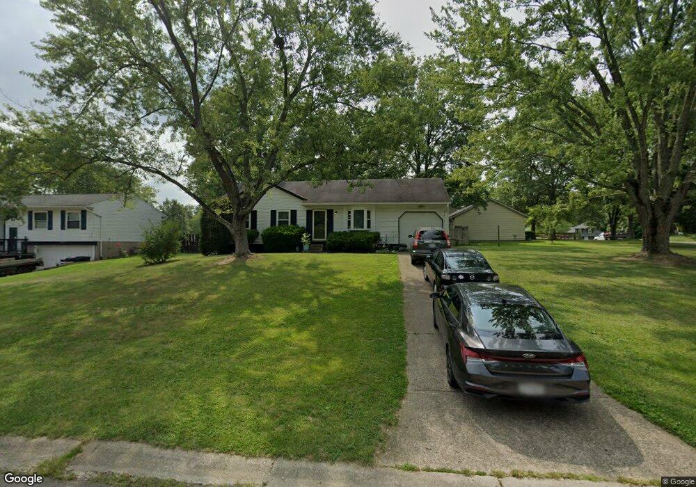
1521 Rolling Knoll Dr Loveland, OH 45140
Estimated Value: $210,907 - $248,000
3
Beds
1
Bath
950
Sq Ft
$248/Sq Ft
Est. Value
About This Home
This home is located at 1521 Rolling Knoll Dr, Loveland, OH 45140 and is currently estimated at $235,477, approximately $247 per square foot. 1521 Rolling Knoll Dr is a home located in Clermont County with nearby schools including Marr/Cook Elementary School, Spaulding Elementary School, and Goshen Middle School.
Ownership History
Date
Name
Owned For
Owner Type
Purchase Details
Closed on
Mar 1, 2011
Sold by
Estate Of Millard E Malblanc
Bought by
Malblanc Mary J
Current Estimated Value
Create a Home Valuation Report for This Property
The Home Valuation Report is an in-depth analysis detailing your home's value as well as a comparison with similar homes in the area
Home Values in the Area
Average Home Value in this Area
Purchase History
| Date | Buyer | Sale Price | Title Company |
|---|---|---|---|
| Malblanc Mary J | -- | None Available |
Source: Public Records
Tax History Compared to Growth
Tax History
| Year | Tax Paid | Tax Assessment Tax Assessment Total Assessment is a certain percentage of the fair market value that is determined by local assessors to be the total taxable value of land and additions on the property. | Land | Improvement |
|---|---|---|---|---|
| 2024 | $1,527 | $44,030 | $9,170 | $34,860 |
| 2023 | $1,507 | $44,030 | $9,170 | $34,860 |
| 2022 | $1,468 | $38,640 | $8,050 | $30,590 |
| 2021 | $1,477 | $38,640 | $8,050 | $30,590 |
| 2020 | $1,379 | $38,640 | $8,050 | $30,590 |
| 2019 | $1,567 | $41,340 | $11,270 | $30,070 |
| 2018 | $1,574 | $41,340 | $11,270 | $30,070 |
| 2017 | $1,269 | $41,340 | $11,270 | $30,070 |
| 2016 | $1,269 | $33,360 | $9,100 | $24,260 |
| 2015 | $1,145 | $33,360 | $9,100 | $24,260 |
| 2014 | $1,145 | $33,360 | $9,100 | $24,260 |
| 2013 | $922 | $29,440 | $9,800 | $19,640 |
Source: Public Records
Map
Nearby Homes
- 6716 Oakland Rd
- 6725 Oakland Rd
- 1333 Cross Creek Dr
- Brookside Plan at Oakridge Estates - Signature Series
- Shaker Run Plan at Oakridge Estates - Signature Series
- Medinah Plan at Oakridge Estates - Signature Series
- Shadow Creek Plan at Oakridge Estates - Signature Series
- Oakmont Plan at Oakridge Estates - Signature Series
- Sonoma Plan at Oakridge Estates - Signature Series
- Piedmont Plan at Oakridge Estates - Signature Series
- Ferndale Plan at Oakridge Estates - Signature Series
- Equestrian Plan at Oakridge Estates - Signature Series
- Rubicon Plan at Oakridge Estates - Signature Series
- Meridian Plan at Oakridge Estates - Signature Series
- Peachtree Plan at Oakridge Estates - Signature Series
- Breckenridge Plan at Oakridge Estates - Signature Series
- Somerset Plan at Oakridge Estates - Signature Series
- Crooked Stick Plan at Oakridge Estates - Signature Series
- Heatherwood Plan at Oakridge Estates - Signature Series
- Cypress Pointe Plan at Oakridge Estates - Signature Series
- 1525 Rolling Knoll Dr
- 1520 Rolling Knoll Dr
- 1538 E Meadowbrook Dr
- 1523 E Meadowbrook Dr
- 1527 Rolling Knoll Dr
- 1526 Rolling Knoll Dr
- 1534 W Meadowbrook Dr
- 1542 E Meadowbrook Dr
- 1521 W Meadowbrook Dr
- 1540 E Meadowbrook Dr
- 1525 E Meadowbrook Dr
- 1515 Rolling Knoll Dr
- 6697 Willowridge Ct
- 1544 E Meadowbrook Dr
- 1532 W Meadowbrook Dr
- 1527 E Meadowbrook Dr
- 1514 Rolling Knoll Dr
- 1511 Rolling Knoll Dr
- 6699 Willowridge Ct
- 1546 E Meadowbrook Dr