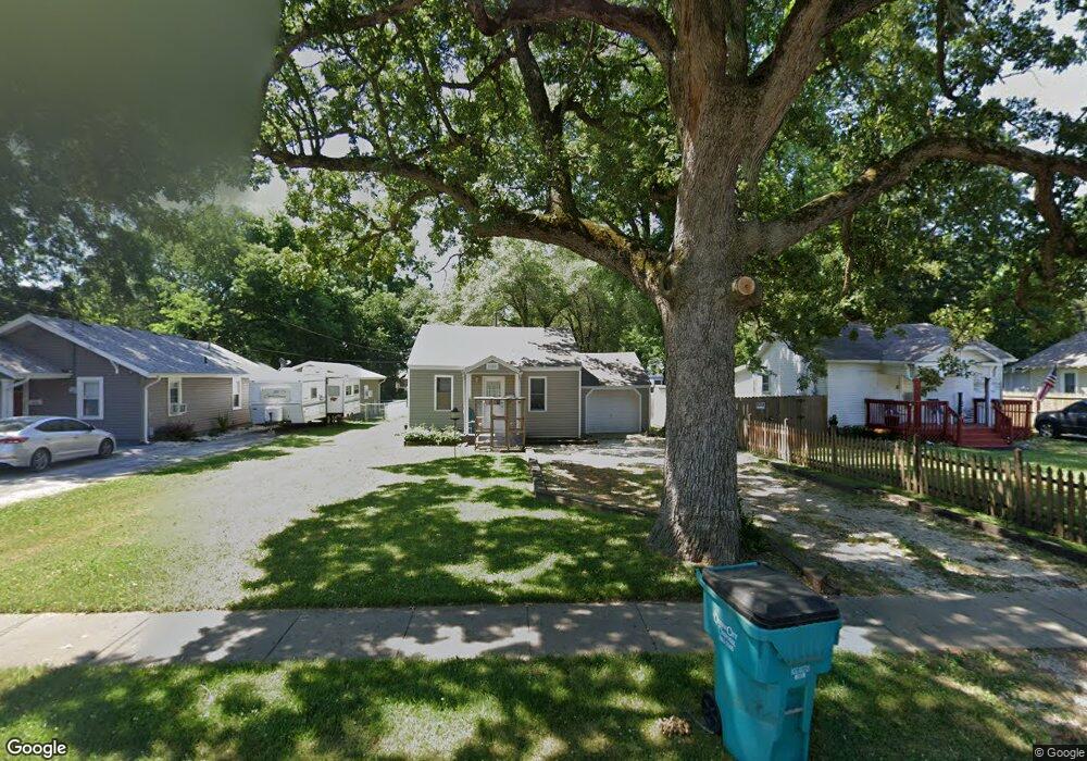
1522 E Central St Springfield, MO 65802
Cooper Park NeighborhoodEstimated Value: $83,301 - $147,000
2
Beds
1
Bath
624
Sq Ft
$178/Sq Ft
Est. Value
About This Home
This home is located at 1522 E Central St, Springfield, MO 65802 and is currently estimated at $111,075, approximately $178 per square foot. 1522 E Central St is a home located in Greene County with nearby schools including Weller Elementary School, Pipkin Middle School, and Central High School.
Ownership History
Date
Name
Owned For
Owner Type
Purchase Details
Closed on
Jul 13, 2007
Sold by
Pitts David
Bought by
David Pitts Properties Llc
Current Estimated Value
Create a Home Valuation Report for This Property
The Home Valuation Report is an in-depth analysis detailing your home's value as well as a comparison with similar homes in the area
Home Values in the Area
Average Home Value in this Area
Purchase History
| Date | Buyer | Sale Price | Title Company |
|---|---|---|---|
| David Pitts Properties Llc | -- | None Available |
Source: Public Records
Tax History
| Year | Tax Paid | Tax Assessment Tax Assessment Total Assessment is a certain percentage of the fair market value that is determined by local assessors to be the total taxable value of land and additions on the property. | Land | Improvement |
|---|---|---|---|---|
| 2025 | $373 | $7,480 | $3,910 | $3,570 |
| 2024 | $322 | $6,000 | $2,620 | $3,380 |
| 2023 | $320 | $6,000 | $2,620 | $3,380 |
| 2022 | $322 | $5,890 | $2,620 | $3,270 |
| 2021 | $322 | $5,890 | $2,620 | $3,270 |
| 2020 | $317 | $5,550 | $2,620 | $2,930 |
| 2019 | $308 | $5,550 | $2,620 | $2,930 |
| 2018 | $262 | $4,730 | $2,620 | $2,110 |
| 2017 | $0 | $4,730 | $2,620 | $2,110 |
| 2016 | $259 | $4,730 | $2,620 | $2,110 |
| 2015 | $257 | $4,730 | $2,620 | $2,110 |
| 2014 | $253 | $4,620 | $2,620 | $2,000 |
Source: Public Records
Map
Nearby Homes
- 1628 E Brower St
- 1701 E Chestnut St
- 922 N Prospect Ave
- 1126 N Rogers Ave
- 1129 N Rogers Ave
- 934 N National Ave
- 1311 N Fremont Ave
- 1133 N Prospect Ave
- 1341 N Fremont Ave
- 1235 N Prospect Ave
- 217 S Pickwick Ave
- 1255 N National Ave
- 1462 E Mcdaniel St
- 1525 E Cairo St
- 1213 E Saint Louis St
- 338 S Weller Ave
- 1360 E Locust St
- 1700 E Cairo St
- 1435 E Walnut St
- 1345 E Walnut St
- 1516 E Central St
- 1528 E Central St
- 817 N Delaware Ave
- 1512 E Central St
- 1508 E Central St
- 815 N Delaware Ave
- 1525 E Brower St
- 1531 E Brower St
- 1519 E Brower St
- 901 N Delaware Ave
- 1511 E Brower St
- 1601 E 8th St N
- 1500 E Central St
- 1511 E Central St
- 903 N Delaware Ave
- 1507 E Brower St
- 1537 E Brower St
- 1604 E Central St
- 1607 E 8th St N
- 1503 E Brower St
Your Personal Tour Guide
Ask me questions while you tour the home.