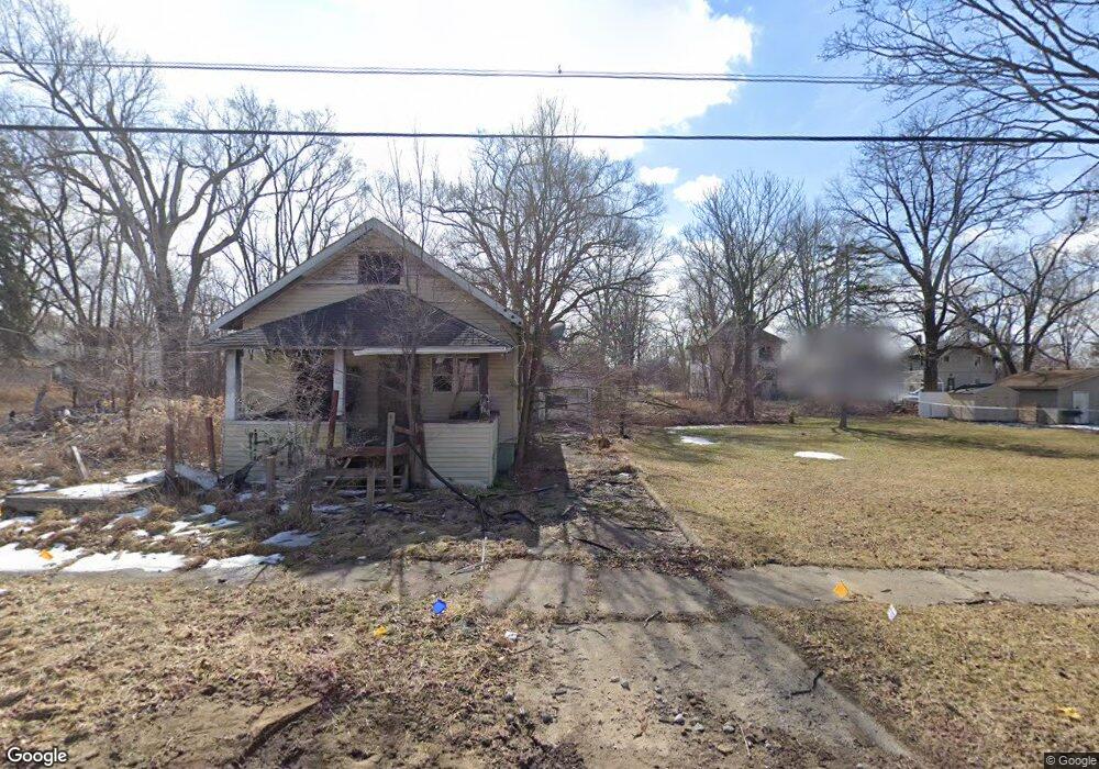
1522 Jane Ave Flint, MI 48506
Eastside NeighborhoodEstimated Value: $17,326 - $92,000
2
Beds
1
Bath
780
Sq Ft
$63/Sq Ft
Est. Value
About This Home
This home is located at 1522 Jane Ave, Flint, MI 48506 and is currently estimated at $49,082, approximately $62 per square foot. 1522 Jane Ave is a home located in Genesee County with nearby schools including Potter School, Flint Cultural Center Academy, and WAY Academy of Flint.
Ownership History
Date
Name
Owned For
Owner Type
Purchase Details
Closed on
Dec 2, 2021
Sold by
Genesee County Land Bank Authority
Bought by
Ames Michele
Current Estimated Value
Purchase Details
Closed on
Dec 22, 2014
Sold by
Genesee County Treasurer
Bought by
Genesee County Land Bank
Purchase Details
Closed on
Jul 1, 2009
Sold by
Joseph Perry
Bought by
Wells Fargo Bank Na
Purchase Details
Closed on
Oct 15, 2004
Sold by
Deering Anthony T and Deering Viola M
Bought by
Joseph Perry
Purchase Details
Closed on
Mar 1, 2000
Sold by
Deering A T
Bought by
Deering Anthony T and Deering Viola M
Create a Home Valuation Report for This Property
The Home Valuation Report is an in-depth analysis detailing your home's value as well as a comparison with similar homes in the area
Home Values in the Area
Average Home Value in this Area
Purchase History
| Date | Buyer | Sale Price | Title Company |
|---|---|---|---|
| Ames Michele | $250 | None Listed On Document | |
| Genesee County Land Bank | -- | None Available | |
| Wells Fargo Bank Na | $14,146 | None Available | |
| Joseph Perry | $15,000 | First American Title | |
| Deering Anthony T | -- | -- |
Source: Public Records
Tax History
| Year | Tax Paid | Tax Assessment Tax Assessment Total Assessment is a certain percentage of the fair market value that is determined by local assessors to be the total taxable value of land and additions on the property. | Land | Improvement |
|---|---|---|---|---|
| 2025 | $157 | $1,900 | $0 | $0 |
| 2024 | $148 | $1,600 | $0 | $0 |
| 2023 | $154 | $1,300 | $0 | $0 |
| 2022 | $0 | $1,200 | $0 | $0 |
| 2021 | $0 | $0 | $0 | $0 |
| 2020 | $0 | $0 | $0 | $0 |
| 2019 | $0 | $0 | $0 | $0 |
| 2018 | $0 | $0 | $0 | $0 |
| 2017 | $0 | $0 | $0 | $0 |
| 2016 | $0 | $0 | $0 | $0 |
| 2015 | -- | $0 | $0 | $0 |
| 2014 | -- | $0 | $0 | $0 |
| 2012 | -- | $300 | $0 | $0 |
Source: Public Records
Map
Nearby Homes
- 1513 Jane Ave
- 1454 Delaware Ave
- 1529 Broadway Blvd
- 1629 New York Ave
- 1445 Maryland Ave
- 1721 New York Ave
- 1805 Bennett Ave
- 1420 Dakota Ave
- 1518 Leith St
- 1422 Leith St
- 1826 Dakota Ave
- 1273 Broadway Blvd
- 1526 Montana Ave
- 1733 Oklahoma Ave
- 2506 Arlington Ave
- 1656 Montana Ave
- 1609 Ohio Ave
- 1623 Montana Ave
- 1805 Montana Ave
- 2217 Maryland Ave