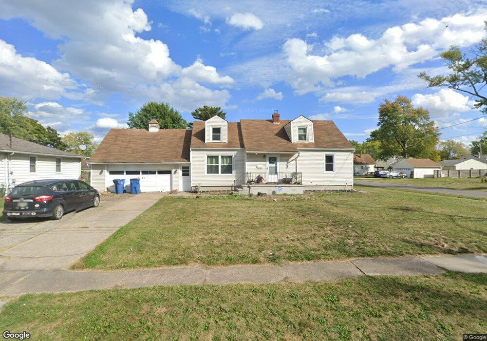
1525 Euclid Ave Lorain, OH 44052
Estimated Value: $139,000 - $160,713
4
Beds
1
Bath
1,437
Sq Ft
$106/Sq Ft
Est. Value
About This Home
This home is located at 1525 Euclid Ave, Lorain, OH 44052 and is currently estimated at $152,178, approximately $105 per square foot. 1525 Euclid Ave is a home located in Lorain County with nearby schools including Larkmoor Elementary School, Longfellow Middle School, and Lorain High School.
Ownership History
Date
Name
Owned For
Owner Type
Purchase Details
Closed on
Feb 12, 2024
Sold by
Zaleski-Turley Linda M
Bought by
Zaleski Management Llc
Current Estimated Value
Purchase Details
Closed on
Feb 12, 2019
Sold by
Turley Paul E
Bought by
Zaleski Turley Linda M and Turley Linda
Purchase Details
Closed on
Jul 2, 2009
Sold by
The Huntington National Bank
Bought by
Turley Paul and Turley Linda
Purchase Details
Closed on
Apr 21, 2008
Sold by
Najmi Theresa M and Najmi Rashid
Bought by
The Huntington National Bank
Purchase Details
Closed on
Sep 30, 1994
Sold by
Est Marian E Tillison
Bought by
Najmi Rashid and Najmi Theresa M
Home Financials for this Owner
Home Financials are based on the most recent Mortgage that was taken out on this home.
Original Mortgage
$58,900
Interest Rate
8.6%
Mortgage Type
New Conventional
Create a Home Valuation Report for This Property
The Home Valuation Report is an in-depth analysis detailing your home's value as well as a comparison with similar homes in the area
Home Values in the Area
Average Home Value in this Area
Purchase History
| Date | Buyer | Sale Price | Title Company |
|---|---|---|---|
| Zaleski Management Llc | -- | None Listed On Document | |
| Zaleski Turley Linda M | -- | None Available | |
| Turley Paul | $22,700 | Hbi Title | |
| The Huntington National Bank | $66,000 | None Available | |
| Najmi Rashid | $62,000 | -- |
Source: Public Records
Mortgage History
| Date | Status | Borrower | Loan Amount |
|---|---|---|---|
| Previous Owner | Najmi Rashid | $58,900 |
Source: Public Records
Tax History Compared to Growth
Tax History
| Year | Tax Paid | Tax Assessment Tax Assessment Total Assessment is a certain percentage of the fair market value that is determined by local assessors to be the total taxable value of land and additions on the property. | Land | Improvement |
|---|---|---|---|---|
| 2024 | $2,017 | $47,740 | $5,537 | $42,203 |
| 2023 | $1,564 | $29,596 | $5,821 | $23,776 |
| 2022 | $1,551 | $29,596 | $5,821 | $23,776 |
| 2021 | $1,550 | $29,596 | $5,821 | $23,776 |
| 2020 | $1,480 | $24,550 | $4,830 | $19,720 |
| 2019 | $1,472 | $24,550 | $4,830 | $19,720 |
| 2018 | $1,637 | $24,550 | $4,830 | $19,720 |
| 2017 | $1,801 | $28,300 | $6,490 | $21,810 |
| 2016 | $1,787 | $28,300 | $6,490 | $21,810 |
| 2015 | $1,688 | $28,300 | $6,490 | $21,810 |
| 2014 | $1,684 | $26,960 | $6,190 | $20,770 |
| 2013 | $1,592 | $26,960 | $6,190 | $20,770 |
Source: Public Records
Map
Nearby Homes
- 1619 New Mexico Ave
- 2947 Colorado Ave
- 2922 Eastlawn St
- 1330 Pennsylvania Ave
- 0 New Hampshire Ave
- 0 New Hampshire Ave
- 1623 Nevada Ave
- 1605 Ohio Ave
- 0 Eastlawn St Unit 5106705
- 3427 Crehore St
- 2236 Randall St
- 2149 Hancock St
- 2817 Mckinley St
- 0 Root Rd
- 2279 Adams St
- 805 Euclid Ave
- 2417 G St
- 1273 Michigan Ave
- 1943 G St
- 1330 Maryland Ave
- 1521 Euclid Ave
- 1526 Pennsylvania Ave
- 1522 Pennsylvania Ave
- 1601 Euclid Ave
- 1518 Pennsylvania Ave
- 1600 Pennsylvania Ave
- 1514 Pennsylvania Ave
- 1518 Euclid Ave
- 1609 Euclid Ave
- 1604 Pennsylvania Ave
- 2938 Randall St
- 1510 Pennsylvania Ave
- 1509 Euclid Ave
- 1606 Euclid Ave
- 1608 Pennsylvania Ave
- 1510 Euclid Ave
- 1611 Euclid Ave
- 1506 Pennsylvania Ave
- 1503 Euclid Ave
- 1612 Pennsylvania Ave