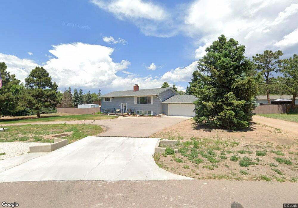
1526 Fuller Rd Colorado Springs, CO 80920
Falcon Estates NeighborhoodEstimated Value: $592,000 - $710,888
4
Beds
5
Baths
1,494
Sq Ft
$439/Sq Ft
Est. Value
About This Home
This home is located at 1526 Fuller Rd, Colorado Springs, CO 80920 and is currently estimated at $655,222, approximately $438 per square foot. 1526 Fuller Rd is a home located in El Paso County with nearby schools including Pioneer Elementary School, Mountain Ridge Middle School, and Rampart High School.
Ownership History
Date
Name
Owned For
Owner Type
Purchase Details
Closed on
Jun 13, 2016
Sold by
Dean D Johnson Family Trust
Bought by
Brown Edward D
Current Estimated Value
Purchase Details
Closed on
Apr 14, 1997
Sold by
Johnson Dean D and Johnson Marilyn A
Bought by
Johnson Marilyn A and Dean D Johnson Family Trust
Purchase Details
Closed on
Nov 22, 1996
Sold by
Johnson Dean D and Johnson Marilyn A
Bought by
Johnson Dean D
Purchase Details
Closed on
Dec 23, 1963
Bought by
Brown Edward D
Create a Home Valuation Report for This Property
The Home Valuation Report is an in-depth analysis detailing your home's value as well as a comparison with similar homes in the area
Home Values in the Area
Average Home Value in this Area
Purchase History
| Date | Buyer | Sale Price | Title Company |
|---|---|---|---|
| Brown Edward D | $280,000 | Land Title Guarantee Co | |
| Johnson Marilyn A | -- | -- | |
| Johnson Dean D | -- | -- | |
| Brown Edward D | -- | -- |
Source: Public Records
Tax History Compared to Growth
Tax History
| Year | Tax Paid | Tax Assessment Tax Assessment Total Assessment is a certain percentage of the fair market value that is determined by local assessors to be the total taxable value of land and additions on the property. | Land | Improvement |
|---|---|---|---|---|
| 2025 | $3,071 | $48,780 | -- | -- |
| 2024 | $3,069 | $54,850 | $13,300 | $41,550 |
| 2023 | $3,069 | $54,850 | $13,300 | $41,550 |
| 2022 | $2,138 | $32,310 | $7,350 | $24,960 |
| 2021 | $2,375 | $33,230 | $7,560 | $25,670 |
| 2020 | $1,892 | $24,580 | $6,580 | $18,000 |
| 2019 | $1,872 | $24,580 | $6,580 | $18,000 |
| 2018 | $1,773 | $22,870 | $5,760 | $17,110 |
| 2017 | $1,766 | $22,870 | $5,760 | $17,110 |
| 2016 | $1,818 | $23,520 | $6,370 | $17,150 |
| 2015 | $1,815 | $23,520 | $6,370 | $17,150 |
| 2014 | $1,636 | $21,190 | $5,970 | $15,220 |
Source: Public Records
Map
Nearby Homes
- 1880 Independence Dr
- 1907 Independence Dr
- 1884 Fuller Rd
- 7191 Ross Dr
- 7137 Murdoch Dr
- 7424 Bell Dr
- 1275 Berglind Rd
- 1160 Berglind Rd
- 2110 Whitehorn Dr N
- 1510 York Rd Unit 101
- 1932 Silkwood Dr
- 866 Venhorst Rd
- 2068 Silkwood Dr
- 1871 Brookwood Dr
- 1263 York Rd
- 6699 Bethesda Point Unit B
- 6598 Bethesda Point Unit B
- 6678 Bethesda Point Unit C
- 2006 Summerset Dr
- 6633 Dublin Loop W Unit 4
- 1564 Fuller Rd
- 1563 Cragin Rd
- 1503 Cragin Rd
- 1551 Fuller Rd
- 1533 Cragin Rd
- 1633 Cragin Rd
- 1602 Fuller Rd
- 1593 Cragin Rd
- 1571 Fuller Rd
- 1556 Collins Rd
- 1643 Cragin Rd
- 1642 Fuller Rd
- 1598 Collins Rd
- 1633 Fuller Rd
- 1610 Cragin Rd
- 1663 Cragin Rd
- 1638 Collins Rd
- 1569 Collins Rd
- 1678 Fuller Rd
- 1590 Cragin Rd