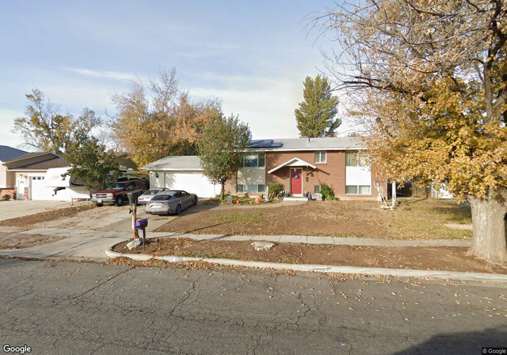
1526 S 1100 W Syracuse, UT 84075
Estimated Value: $429,968 - $449,000
5
Beds
2
Baths
2,058
Sq Ft
$212/Sq Ft
Est. Value
About This Home
This home is located at 1526 S 1100 W, Syracuse, UT 84075 and is currently estimated at $436,992, approximately $212 per square foot. 1526 S 1100 W is a home located in Davis County with nearby schools including Cook School, Syracuse Junior High School, and Syracuse High School.
Ownership History
Date
Name
Owned For
Owner Type
Purchase Details
Closed on
Jun 17, 2019
Sold by
Teramoto Terry Keola Chiyotaro
Bought by
Teramoto Kimberly and Teramoto Terry
Current Estimated Value
Home Financials for this Owner
Home Financials are based on the most recent Mortgage that was taken out on this home.
Original Mortgage
$220,543
Outstanding Balance
$194,493
Interest Rate
4.25%
Mortgage Type
FHA
Estimated Equity
$242,499
Purchase Details
Closed on
Sep 9, 2016
Sold by
Chlyotara Teramoto Sr Terry Keola
Bought by
Sheffer Dale M and Sheffer Pamela J
Create a Home Valuation Report for This Property
The Home Valuation Report is an in-depth analysis detailing your home's value as well as a comparison with similar homes in the area
Home Values in the Area
Average Home Value in this Area
Purchase History
| Date | Buyer | Sale Price | Title Company |
|---|---|---|---|
| Teramoto Kimberly | -- | First American Title | |
| Sheffer Dale M | -- | North American Title |
Source: Public Records
Mortgage History
| Date | Status | Borrower | Loan Amount |
|---|---|---|---|
| Open | Teramoto Kimberly | $220,543 |
Source: Public Records
Tax History Compared to Growth
Tax History
| Year | Tax Paid | Tax Assessment Tax Assessment Total Assessment is a certain percentage of the fair market value that is determined by local assessors to be the total taxable value of land and additions on the property. | Land | Improvement |
|---|---|---|---|---|
| 2025 | $2,212 | $213,400 | $124,311 | $89,089 |
| 2024 | $2,152 | $209,000 | $102,194 | $106,806 |
| 2023 | $2,006 | $355,000 | $142,430 | $212,570 |
| 2022 | $2,109 | $204,600 | $82,074 | $122,526 |
| 2021 | $1,964 | $295,000 | $121,216 | $173,784 |
| 2020 | $1,719 | $250,000 | $105,904 | $144,096 |
| 2019 | $1,574 | $226,000 | $103,136 | $122,864 |
| 2018 | $1,404 | $200,000 | $99,811 | $100,189 |
| 2016 | $1,183 | $88,385 | $38,323 | $50,062 |
| 2015 | $1,134 | $80,740 | $38,358 | $42,382 |
| 2014 | $1,074 | $77,891 | $38,358 | $39,533 |
| 2013 | -- | $72,222 | $28,435 | $43,787 |
Source: Public Records
Map
Nearby Homes
- 1385 S 1100 W
- 1622 S 1000 W
- 1154 W 1700 S
- 1121 W 1290 S
- 1481 S Melanie Ln
- 1384 S Melanie Ln
- 1166 Dallas St
- 1153 W 1875 S Unit 223
- 1876 S 1230 W
- 992 W 1910 S
- 929 W 1920 S Unit A
- 1142 W 2050 S
- 1148 W 2050 S
- 877 W 1920 S Unit C
- 1062 W 2050 S
- 1327 S 1650 W
- 1079 W 2050 S
- 1027 W 2050 S
- 1251 S 1650 W
- 1466 Earl Cir