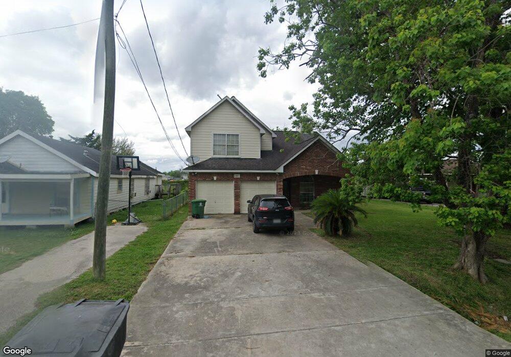
1527 Skinner Rd Houston, TX 77093
Eastex-Jensen NeighborhoodEstimated Value: $338,000 - $425,197
4
Beds
3
Baths
2,192
Sq Ft
$166/Sq Ft
Est. Value
About This Home
This home is located at 1527 Skinner Rd, Houston, TX 77093 and is currently estimated at $363,549, approximately $165 per square foot. 1527 Skinner Rd is a home located in Harris County with nearby schools including Coop Elementary School, Patrick Henry Middle School, and Sam Houston Math, Science & Technology Center.
Ownership History
Date
Name
Owned For
Owner Type
Purchase Details
Closed on
Apr 17, 2002
Sold by
Mancillas Cruz
Bought by
Plans & Permits Inc
Current Estimated Value
Home Financials for this Owner
Home Financials are based on the most recent Mortgage that was taken out on this home.
Original Mortgage
$6,000
Interest Rate
6.83%
Mortgage Type
Seller Take Back
Create a Home Valuation Report for This Property
The Home Valuation Report is an in-depth analysis detailing your home's value as well as a comparison with similar homes in the area
Home Values in the Area
Average Home Value in this Area
Purchase History
| Date | Buyer | Sale Price | Title Company |
|---|---|---|---|
| Plans & Permits Inc | -- | Texas American Title Company |
Source: Public Records
Mortgage History
| Date | Status | Borrower | Loan Amount |
|---|---|---|---|
| Closed | Plans & Permits Inc | $6,000 |
Source: Public Records
Tax History Compared to Growth
Tax History
| Year | Tax Paid | Tax Assessment Tax Assessment Total Assessment is a certain percentage of the fair market value that is determined by local assessors to be the total taxable value of land and additions on the property. | Land | Improvement |
|---|---|---|---|---|
| 2025 | $9,685 | $344,442 | $91,943 | $252,499 |
| 2024 | $9,685 | $462,871 | $86,112 | $376,759 |
| 2023 | $9,685 | $391,545 | $67,275 | $324,270 |
| 2022 | $7,006 | $318,187 | $56,063 | $262,124 |
| 2021 | $6,362 | $272,948 | $40,365 | $232,583 |
| 2020 | $6,222 | $256,934 | $40,365 | $216,569 |
| 2019 | $6,502 | $256,934 | $40,365 | $216,569 |
| 2018 | $4,439 | $175,404 | $30,947 | $144,457 |
| 2017 | $4,435 | $175,404 | $30,947 | $144,457 |
| 2016 | $4,435 | $175,404 | $30,947 | $144,457 |
| 2015 | $3,213 | $125,000 | $24,668 | $100,332 |
| 2014 | $3,213 | $125,000 | $24,668 | $100,332 |
Source: Public Records
Map
Nearby Homes
- 1002 Grenfell Ln
- 1829 Skinner Rd
- 10514 Exeter St
- 10022 E Hardy Rd
- 10512 Exeter St
- 9910 E Hardy Rd
- 1908 Little York Rd
- 11514 Courtshire Rd
- 11314 Courtshire Rd
- 1802 Kowis St
- 11026 Catamore St
- 513 Mayford St
- 11018 Catamore St
- 606 Cresline St
- 2122 Kowis St
- 1930 Cromwell St
- 11334 Carla St
- 401 Cresline St
- 2315 Langley Rd
- 11110 E Hardy Rd
- 1523 Skinner Rd
- 1533 Skinner Rd
- 1521 Skinner Rd
- 1519 Skinner Rd
- 1515 Skinner Rd
- 1534 Skinner Rd
- 1423 Skinner Rd
- 1421 Skinner Rd
- 1518 Skinner Rd
- 1530 Skinner Rd
- 1419 Skinner Rd
- 1606 Skinner Rd
- 1420 Skinner Rd
- 1602 Skinner Rd
- 1416 Skinner Rd
- 1417 Skinner Rd
- 1610 Skinner Rd
- 1612 Skinner Rd
- 10554 E Hardy Rd
- 1413 Skinner Rd