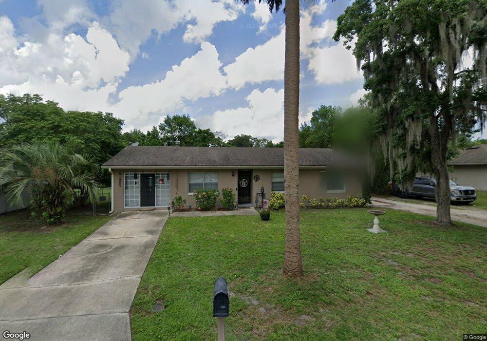
1527 W Euclid Ave Deland, FL 32720
West DeLand NeighborhoodEstimated Value: $233,000 - $259,000
3
Beds
2
Baths
1,395
Sq Ft
$177/Sq Ft
Est. Value
About This Home
This home is located at 1527 W Euclid Ave, Deland, FL 32720 and is currently estimated at $246,357, approximately $176 per square foot. 1527 W Euclid Ave is a home located in Volusia County with nearby schools including Woodward Avenue Elementary School, Deland High School, and Southwestern Middle School.
Ownership History
Date
Name
Owned For
Owner Type
Purchase Details
Closed on
Feb 18, 2014
Sold by
Arney Norma J and Arney James Robert
Bought by
Drumb Norma J and Arney James Robert
Current Estimated Value
Purchase Details
Closed on
Jun 9, 2008
Sold by
Rowan Donald W and Rowan Diana L
Bought by
Arney Norma and Drumb James
Purchase Details
Closed on
Oct 8, 2001
Sold by
Arney Norma J
Bought by
Arney Norma J and Arney James Robert
Purchase Details
Closed on
Mar 15, 1973
Bought by
West Sharon A
Create a Home Valuation Report for This Property
The Home Valuation Report is an in-depth analysis detailing your home's value as well as a comparison with similar homes in the area
Home Values in the Area
Average Home Value in this Area
Purchase History
| Date | Buyer | Sale Price | Title Company |
|---|---|---|---|
| Drumb Norma J | -- | None Available | |
| Arney Norma | $1,000 | None Available | |
| Arney Norma J | -- | -- | |
| West Sharon A | $18,400 | -- |
Source: Public Records
Tax History Compared to Growth
Tax History
| Year | Tax Paid | Tax Assessment Tax Assessment Total Assessment is a certain percentage of the fair market value that is determined by local assessors to be the total taxable value of land and additions on the property. | Land | Improvement |
|---|---|---|---|---|
| 2025 | $1,097 | $88,965 | -- | -- |
| 2024 | $1,097 | $86,458 | -- | -- |
| 2023 | $1,097 | $83,940 | $0 | $0 |
| 2022 | $1,045 | $81,495 | $0 | $0 |
| 2021 | $1,053 | $79,121 | $0 | $0 |
| 2019 | $1,034 | $76,275 | $0 | $0 |
| 2018 | $1,009 | $74,853 | $0 | $0 |
| 2017 | $998 | $73,313 | $0 | $0 |
| 2016 | $965 | $71,805 | $0 | $0 |
| 2015 | $985 | $71,306 | $0 | $0 |
| 2014 | $983 | $70,740 | $0 | $0 |
Source: Public Records
Map
Nearby Homes
- 320 S Woodward Ave
- 1415 Talton Ave
- 1541 W Talton Ave
- 1314 Talton Ave
- 541 Rhodes Dr
- 0 Coberly Dr Unit MFRO6312050
- 243 S Hull Ave
- 1512 W Winnemissett Ave
- 732 Mockingbird Ln
- 1676 Andover Ridge Dr
- 1655 Andover Ridge Dr
- 1659 Andover Ridge Dr
- 141 Addle Hill Ct
- 131 Addle Hill Ct
- 1705 Bent Branch Ave
- 1141 W Euclid Ave
- 1697 Andover Ridge Dr
- 1601 Andover Ridge Dr
- 1701 Andover Ridge Dr
- 131 S Sheridan Ave
- 1531 W Euclid Ave
- 1523 W Euclid Ave
- 1535 W Euclid Ave
- 1500 Brittain Ave
- 1502 Brittain Ave
- 1528 W Euclid Ave
- 1506 Brittain Ave
- 1524 W Euclid Ave
- 440 S Woodward Ave
- 1539 W Euclid Ave
- 1520 W Euclid Ave
- 1532 W Euclid Ave
- 1514 Brittain Ave
- 1516 W Euclid Ave
- 1536 W Euclid Ave
- 1549 W Euclid Ave
- 1503 Brittain Ave
- 1505 Brittain Ave
- 1501 Brittain Ave
- 590 S Woodward Ave