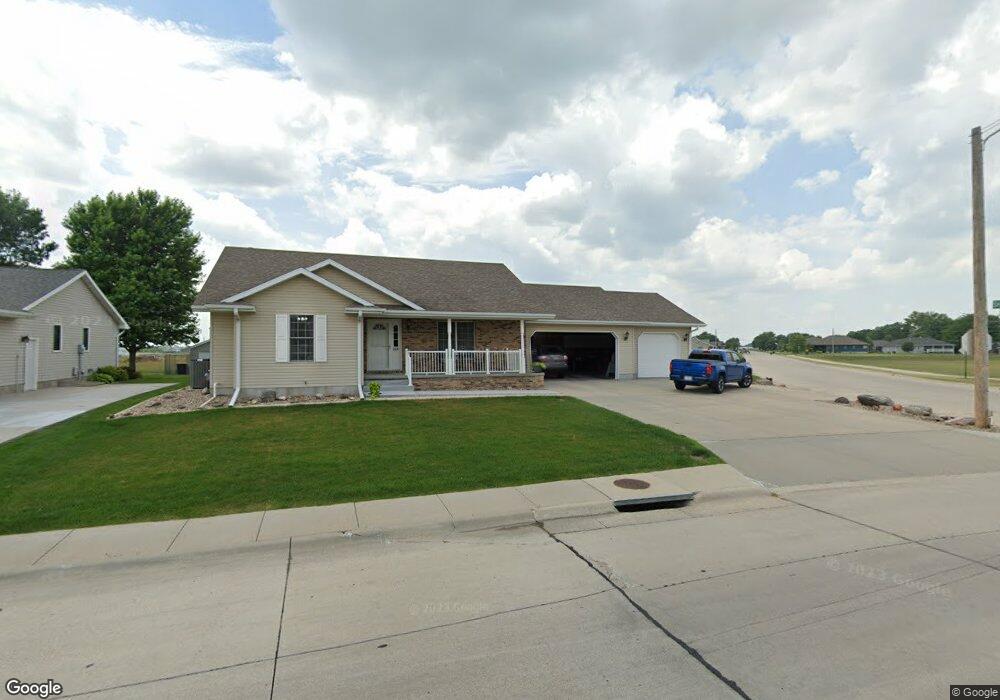
1528 Mansfield Rd Grand Island, NE 68803
Estimated Value: $338,591 - $405,000
3
Beds
2
Baths
1,640
Sq Ft
$227/Sq Ft
Est. Value
About This Home
This home is located at 1528 Mansfield Rd, Grand Island, NE 68803 and is currently estimated at $372,898, approximately $227 per square foot. 1528 Mansfield Rd is a home located in Hall County with nearby schools including Engleman Elementary School, Westridge Middle School, and Grand Island Senior High School.
Ownership History
Date
Name
Owned For
Owner Type
Purchase Details
Closed on
Oct 13, 2005
Sold by
Corportation Craig
Bought by
Steinbeck Kenneth A and Steinbeck Elaine L
Current Estimated Value
Home Financials for this Owner
Home Financials are based on the most recent Mortgage that was taken out on this home.
Original Mortgage
$142,149
Interest Rate
5.65%
Mortgage Type
Future Advance Clause Open End Mortgage
Purchase Details
Closed on
Oct 12, 2005
Sold by
Craig Corp
Bought by
Steinbeck Kenneth A and Steinbeck Elanie L
Home Financials for this Owner
Home Financials are based on the most recent Mortgage that was taken out on this home.
Original Mortgage
$142,149
Interest Rate
5.65%
Mortgage Type
Future Advance Clause Open End Mortgage
Purchase Details
Closed on
Jun 17, 2004
Sold by
Grand West Llc
Bought by
Corportation Craig
Create a Home Valuation Report for This Property
The Home Valuation Report is an in-depth analysis detailing your home's value as well as a comparison with similar homes in the area
Home Values in the Area
Average Home Value in this Area
Purchase History
| Date | Buyer | Sale Price | Title Company |
|---|---|---|---|
| Steinbeck Kenneth A | $182,500 | -- | |
| Steinbeck Kenneth A | $183,000 | -- | |
| Corportation Craig | $25,000 | -- |
Source: Public Records
Mortgage History
| Date | Status | Borrower | Loan Amount |
|---|---|---|---|
| Closed | Steinbeck Kenneth A | $142,149 |
Source: Public Records
Tax History Compared to Growth
Tax History
| Year | Tax Paid | Tax Assessment Tax Assessment Total Assessment is a certain percentage of the fair market value that is determined by local assessors to be the total taxable value of land and additions on the property. | Land | Improvement |
|---|---|---|---|---|
| 2024 | $3,830 | $262,910 | $28,332 | $234,578 |
| 2023 | $2,881 | $257,673 | $28,332 | $229,341 |
| 2022 | $4,654 | $231,566 | $30,000 | $201,566 |
| 2021 | $4,723 | $231,566 | $30,000 | $201,566 |
| 2020 | $4,699 | $231,566 | $30,000 | $201,566 |
| 2019 | $1,745 | $224,573 | $29,000 | $195,573 |
| 2017 | $4,659 | $215,260 | $29,000 | $186,260 |
| 2016 | $4,485 | $215,260 | $29,000 | $186,260 |
| 2015 | $4,554 | $215,260 | $29,000 | $186,260 |
| 2014 | $4,726 | $215,260 | $29,000 | $186,260 |
Source: Public Records
Map
Nearby Homes
- 1429 Mansfield Rd
- 4121 Allen Ave
- 4128 Allen Ave
- 4242 Spur Ln
- 1604 Meadow Rd
- 2110 Topeka Cir
- 1103 Rylie Way
- 2203 Macron St
- 4035 Huff Blvd
- 4043 Huff Blvd
- 4019 Huff Blvd
- 4019 Sacramento Cir
- 4011 Sacramento Cir
- 3931 Chukar Cir
- 1328 Diamond Dr
- 3826 Meadow Way Trail
- 808 Redwood Rd
- 1315 Diamond Dr
- 4145 Elmwood Dr
- 1539 Stonewood Ave
- 1522 Mansfield Rd
- 1516 Mansfield Rd
- 1605 Mansfield Rd
- 1527 Mansfield Rd
- 1521 Mansfield Rd
- 1510 Mansfield Rd
- 1515 Mansfield Rd
- 4145 Allen Ave
- 1504 Mansfield Rd
- 1509 Mansfield Rd
- 4169 Allen Ave
- 4151 Allen Ave
- 4157 Allen Ave
- 4163 Allen Ave
- 4133 Allen Ave
- 1503 Mansfield Rd
- 1428 Mansfield Rd
- 4152 Allen Ave
- 4158 Allen Ave
- 4146 Allen Ave