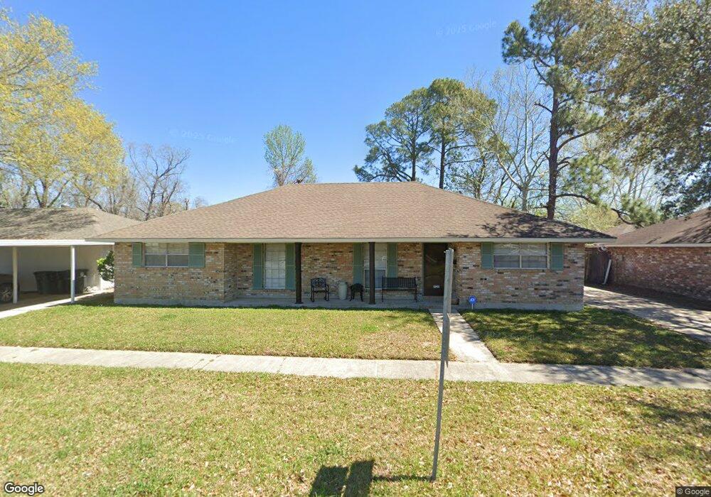
1528 Stacy Dr Baton Rouge, LA 70815
Park Forest/LA North NeighborhoodEstimated Value: $131,000 - $162,000
--
Bed
--
Bath
1,632
Sq Ft
$93/Sq Ft
Est. Value
About This Home
This home is located at 1528 Stacy Dr, Baton Rouge, LA 70815 and is currently estimated at $151,446, approximately $92 per square foot. 1528 Stacy Dr is a home located in East Baton Rouge Parish with nearby schools including LaBelle Aire Elementary School, Park Forest Middle School, and Belaire High School.
Ownership History
Date
Name
Owned For
Owner Type
Purchase Details
Closed on
Oct 19, 2000
Sold by
Laprop Inc
Bought by
Locke Blanche Henley
Current Estimated Value
Purchase Details
Closed on
Oct 28, 1998
Sold by
Hud
Bought by
Quiett Kevin N and Quiett India D
Home Financials for this Owner
Home Financials are based on the most recent Mortgage that was taken out on this home.
Original Mortgage
$67,178
Interest Rate
6.61%
Mortgage Type
FHA
Create a Home Valuation Report for This Property
The Home Valuation Report is an in-depth analysis detailing your home's value as well as a comparison with similar homes in the area
Home Values in the Area
Average Home Value in this Area
Purchase History
| Date | Buyer | Sale Price | Title Company |
|---|---|---|---|
| Locke Blanche Henley | $113 | -- | |
| Quiett Kevin N | $66,200 | -- |
Source: Public Records
Mortgage History
| Date | Status | Borrower | Loan Amount |
|---|---|---|---|
| Previous Owner | Quiett Kevin N | $67,178 |
Source: Public Records
Tax History Compared to Growth
Tax History
| Year | Tax Paid | Tax Assessment Tax Assessment Total Assessment is a certain percentage of the fair market value that is determined by local assessors to be the total taxable value of land and additions on the property. | Land | Improvement |
|---|---|---|---|---|
| 2024 | $512 | $9,610 | $1,232 | $8,378 |
| 2023 | $512 | $8,580 | $1,100 | $7,480 |
| 2022 | $1,199 | $8,580 | $1,100 | $7,480 |
| 2021 | $1,176 | $8,580 | $1,100 | $7,480 |
| 2020 | $1,013 | $8,580 | $1,100 | $7,480 |
| 2019 | $963 | $7,800 | $1,000 | $6,800 |
| 2018 | $952 | $7,800 | $1,000 | $6,800 |
| 2017 | $952 | $7,800 | $1,000 | $6,800 |
| 2016 | $132 | $7,800 | $1,000 | $6,800 |
| 2015 | $110 | $7,600 | $1,000 | $6,600 |
| 2014 | $110 | $7,600 | $1,000 | $6,600 |
| 2013 | -- | $7,600 | $1,000 | $6,600 |
Source: Public Records
Map
Nearby Homes
- 12547 Lorna Ave
- 1466 Harco Dr
- 12424 Cate Ave Unit 12426
- 12013 Shannon Ave
- 12385&12387 Shay Ave
- 2043 Shady Oaks Dr
- 13070 Wallis St
- 12875 King John Place
- 1734 N Rosedale Dr
- 2148 Oak Knoll Dr
- 2121 Oak Knoll Dr
- 11555 E Black Oak Dr
- 371 Kay Dr
- 2150 N Sherwood Forest Dr
- 11755 Archery Dr
- 305 Woodcliff Dr
- 388 Wingate Dr
- 379 Wilton Dr
- 12511 E Robinhood Dr
- 620 Rushmore Dr
- 1544 Stacy Dr
- 1506 Stacy Dr
- 1501 La Annie Dr
- 1562 Stacy Dr
- 1545 La Annie Dr
- 1547 La Annie Dr
- 1559-1563 La Annie Dr
- 1580 Stacy Dr
- 12412 Tams Dr
- 12438 Tams Dr
- 1603 La Annie Dr
- 12358 Tams Dr
- 1543 La Annie Dr
- 12442 Tams Dr
- 12340 Tams Dr
- 1623 La Annie Dr
- 1604 Stacy Dr
- 1520 La Annie Dr
- 12456 Tams Dr
- 1518 La Annie Dr Unit 1520