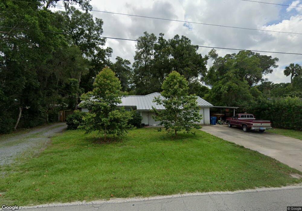
1528 W Euclid Ave Deland, FL 32720
West DeLand NeighborhoodEstimated Value: $344,723 - $398,000
3
Beds
3
Baths
1,666
Sq Ft
$222/Sq Ft
Est. Value
About This Home
This home is located at 1528 W Euclid Ave, Deland, FL 32720 and is currently estimated at $369,431, approximately $221 per square foot. 1528 W Euclid Ave is a home located in Volusia County with nearby schools including Woodward Avenue Elementary School, Deland High School, and Southwestern Middle School.
Ownership History
Date
Name
Owned For
Owner Type
Purchase Details
Closed on
Jan 27, 2021
Sold by
Garvell Justin and Garvell Sira
Bought by
Garvell Justin
Current Estimated Value
Purchase Details
Closed on
May 9, 2002
Sold by
Hogan Laraine S and Hogan Carl M
Bought by
Pangreic Sira and Gravell Justin
Home Financials for this Owner
Home Financials are based on the most recent Mortgage that was taken out on this home.
Original Mortgage
$49,400
Interest Rate
7.12%
Mortgage Type
Purchase Money Mortgage
Purchase Details
Closed on
Aug 15, 1990
Bought by
Gravell Sira Pangrcic
Purchase Details
Closed on
Sep 15, 1986
Bought by
Gravell Sira Pangrcic
Purchase Details
Closed on
May 15, 1972
Bought by
Gravell Sira Pangrcic
Create a Home Valuation Report for This Property
The Home Valuation Report is an in-depth analysis detailing your home's value as well as a comparison with similar homes in the area
Home Values in the Area
Average Home Value in this Area
Purchase History
| Date | Buyer | Sale Price | Title Company |
|---|---|---|---|
| Garvell Justin | -- | Accommodation | |
| Pangreic Sira | $52,000 | -- | |
| Gravell Sira Pangrcic | $100 | -- | |
| Gravell Sira Pangrcic | $100 | -- | |
| Gravell Sira Pangrcic | $17,600 | -- |
Source: Public Records
Mortgage History
| Date | Status | Borrower | Loan Amount |
|---|---|---|---|
| Previous Owner | Pangreic Sira | $49,400 |
Source: Public Records
Tax History Compared to Growth
Tax History
| Year | Tax Paid | Tax Assessment Tax Assessment Total Assessment is a certain percentage of the fair market value that is determined by local assessors to be the total taxable value of land and additions on the property. | Land | Improvement |
|---|---|---|---|---|
| 2025 | $2,162 | $152,361 | -- | -- |
| 2024 | $2,162 | $148,068 | -- | -- |
| 2023 | $2,162 | $143,756 | $0 | $0 |
| 2022 | $5,315 | $273,281 | $62,612 | $210,669 |
| 2021 | $2,164 | $135,504 | $0 | $0 |
| 2020 | $1,975 | $125,870 | $0 | $0 |
| 2019 | $2,022 | $123,040 | $0 | $0 |
| 2018 | $2,003 | $120,746 | $0 | $0 |
| 2017 | $1,985 | $118,262 | $0 | $0 |
| 2016 | $1,890 | $115,830 | $0 | $0 |
| 2015 | $1,924 | $115,025 | $0 | $0 |
| 2014 | $1,904 | $114,112 | $0 | $0 |
Source: Public Records
Map
Nearby Homes
- 541 Rhodes Dr
- 320 S Woodward Ave
- 1415 Talton Ave
- 1314 Talton Ave
- 1541 W Talton Ave
- 1512 W Winnemissett Ave
- 243 S Hull Ave
- 732 Mockingbird Ln
- 0 Coberly Dr Unit MFRO6312050
- 1141 W Euclid Ave
- 1676 Andover Ridge Dr
- 1655 Andover Ridge Dr
- 780 Helen Ave
- 1659 Andover Ridge Dr
- 141 Addle Hill Ct
- 131 S Sheridan Ave
- 131 Addle Hill Ct
- 1705 Bent Branch Ave
- 1601 Andover Ridge Dr
- 0 W Beresford Ave Unit MFRO6313334
- 1532 W Euclid Ave
- 1524 W Euclid Ave
- 1531 W Euclid Ave
- 1527 W Euclid Ave
- 1536 W Euclid Ave
- 1535 W Euclid Ave
- 1520 W Euclid Ave
- 1523 W Euclid Ave
- 1539 W Euclid Ave
- 1516 W Euclid Ave
- 590 S Woodward Ave
- 1502 Brittain Ave
- 440 S Woodward Ave
- 1549 W Euclid Ave
- 1506 Brittain Ave
- 1500 Brittain Ave
- 598 S Woodward Ave
- 1514 Brittain Ave
- 1520 Brittain Ave
- 1559 W Euclid Ave