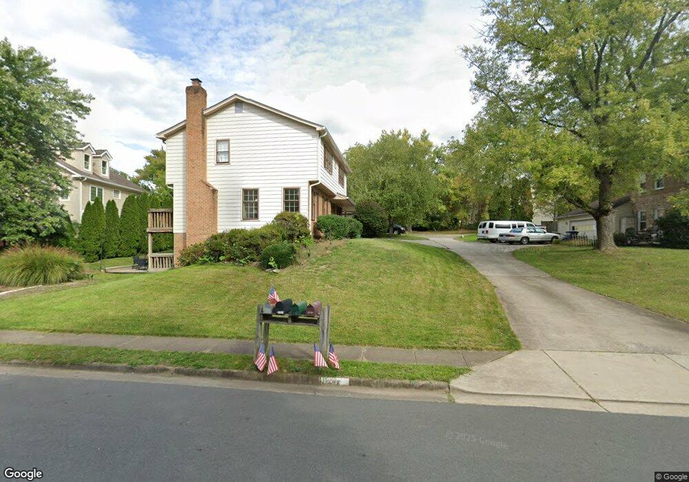
1529 Coat Ridge Rd Herndon, VA 20170
Estimated Value: $738,000 - $817,000
4
Beds
3
Baths
1,764
Sq Ft
$438/Sq Ft
Est. Value
About This Home
This home is located at 1529 Coat Ridge Rd, Herndon, VA 20170 and is currently estimated at $772,162, approximately $437 per square foot. 1529 Coat Ridge Rd is a home located in Fairfax County with nearby schools including Armstrong Elementary, Herndon Middle School, and Herndon High School.
Ownership History
Date
Name
Owned For
Owner Type
Purchase Details
Closed on
Dec 13, 2000
Sold by
Ataia Cesar
Bought by
Dushko Stan
Current Estimated Value
Home Financials for this Owner
Home Financials are based on the most recent Mortgage that was taken out on this home.
Original Mortgage
$190,400
Outstanding Balance
$70,164
Interest Rate
7.7%
Estimated Equity
$701,998
Purchase Details
Closed on
Feb 17, 1994
Sold by
Burkett T
Bought by
Atala Cesar
Create a Home Valuation Report for This Property
The Home Valuation Report is an in-depth analysis detailing your home's value as well as a comparison with similar homes in the area
Home Values in the Area
Average Home Value in this Area
Purchase History
| Date | Buyer | Sale Price | Title Company |
|---|---|---|---|
| Dushko Stan | $238,000 | -- | |
| Atala Cesar | $188,000 | -- |
Source: Public Records
Mortgage History
| Date | Status | Borrower | Loan Amount |
|---|---|---|---|
| Open | Dushko Stan | $190,400 |
Source: Public Records
Tax History Compared to Growth
Tax History
| Year | Tax Paid | Tax Assessment Tax Assessment Total Assessment is a certain percentage of the fair market value that is determined by local assessors to be the total taxable value of land and additions on the property. | Land | Improvement |
|---|---|---|---|---|
| 2025 | $7,502 | $698,140 | $256,000 | $442,140 |
| 2024 | $7,502 | $647,580 | $231,000 | $416,580 |
| 2023 | $6,848 | $606,840 | $231,000 | $375,840 |
| 2022 | $6,798 | $594,470 | $226,000 | $368,470 |
| 2021 | $6,077 | $517,830 | $193,000 | $324,830 |
| 2020 | $6,014 | $508,170 | $193,000 | $315,170 |
| 2019 | $5,723 | $483,550 | $189,000 | $294,550 |
| 2018 | $5,515 | $479,550 | $185,000 | $294,550 |
| 2017 | $5,363 | $461,970 | $176,000 | $285,970 |
| 2016 | $5,294 | $456,970 | $171,000 | $285,970 |
| 2015 | $5,100 | $456,970 | $171,000 | $285,970 |
| 2014 | $4,908 | $440,780 | $171,000 | $269,780 |
Source: Public Records
Map
Nearby Homes
- 1545 Malvern Hill Place
- 1651 Poplar Grove Dr
- 12127 Eddyspark Dr
- 1550 Poplar Grove Dr
- 12028 Walnut Branch Rd
- 11752 Great Owl Cir
- 11709 Summerchase Cir Unit D
- 11723 Summerchase Cir
- 1504 Summerchase Ct Unit 1504-C
- 488 Montalto Dr
- 11767 Arbor Glen Way
- 909 Ashburn St
- 11733 Summerchase Cir Unit 1733C
- 11737 Summerchase Cir
- 1664 Harvest Green Ct
- 349 Reneau Way
- 838 Colvin Ct
- 11665 Gilman Ln
- 11603 Auburn Grove Ct
- 1532 Church Hill Place
- 1531 Coat Ridge Rd
- 1527 Coat Ridge Rd
- 12035 Stuart Ridge Dr
- 1534 Malvern Hill Place
- 1533 Coat Ridge Rd
- 12033 Stuart Ridge Dr
- 12037 Stuart Ridge Dr
- 1536 Malvern Hill Place
- 12028 Winding Way Dr
- 12030 Winding Way Dr
- 12031 Stuart Ridge Dr
- 1532 Malvern Hill Place
- 1538 Malvern Hill Place
- 1536 Coat Ridge Rd
- 12036 Stuart Ridge Dr
- 1538 Coat Ridge Rd
- 1530 Coat Ridge Rd
- 12029 Stuart Ridge Dr
- 12034 Stuart Ridge Dr
- 12038 Stuart Ridge Dr