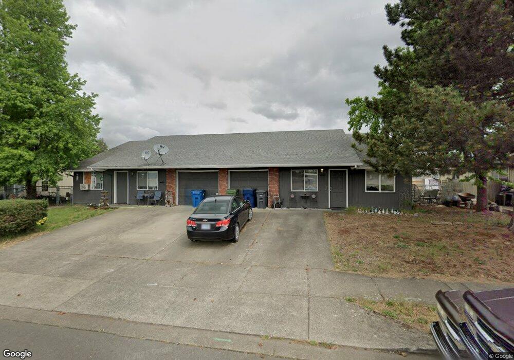
1529 W Locust St Unit 1531 Stayton, OR 97383
Estimated Value: $454,000 - $523,000
3
Beds
4
Baths
2,120
Sq Ft
$231/Sq Ft
Est. Value
About This Home
This home is located at 1529 W Locust St Unit 1531, Stayton, OR 97383 and is currently estimated at $489,755, approximately $231 per square foot. 1529 W Locust St Unit 1531 is a home located in Marion County with nearby schools including Stayton Elementary School, Stayton Middle School, and Stayton High School.
Ownership History
Date
Name
Owned For
Owner Type
Purchase Details
Closed on
Aug 11, 2017
Sold by
Cranston Clarence R and Cranston Judi N
Bought by
Ck Roberts Group Llc
Current Estimated Value
Purchase Details
Closed on
Nov 22, 2006
Sold by
Guzman Roberto
Bought by
Cranston Clarence R and Cranston Judi N
Home Financials for this Owner
Home Financials are based on the most recent Mortgage that was taken out on this home.
Original Mortgage
$177,600
Interest Rate
6.37%
Mortgage Type
Purchase Money Mortgage
Purchase Details
Closed on
Feb 10, 2006
Sold by
Thompson Brenda K and Youmans Brenda Ky
Bought by
Guzman Roberto
Home Financials for this Owner
Home Financials are based on the most recent Mortgage that was taken out on this home.
Original Mortgage
$164,000
Interest Rate
2.5%
Mortgage Type
Fannie Mae Freddie Mac
Create a Home Valuation Report for This Property
The Home Valuation Report is an in-depth analysis detailing your home's value as well as a comparison with similar homes in the area
Home Values in the Area
Average Home Value in this Area
Purchase History
| Date | Buyer | Sale Price | Title Company |
|---|---|---|---|
| Ck Roberts Group Llc | $245,000 | Fat | |
| Cranston Clarence R | $222,000 | First American | |
| Guzman Roberto | $205,000 | First American |
Source: Public Records
Mortgage History
| Date | Status | Borrower | Loan Amount |
|---|---|---|---|
| Previous Owner | Cranston Clarence R | $177,600 | |
| Previous Owner | Guzman Roberto | $164,000 |
Source: Public Records
Tax History Compared to Growth
Tax History
| Year | Tax Paid | Tax Assessment Tax Assessment Total Assessment is a certain percentage of the fair market value that is determined by local assessors to be the total taxable value of land and additions on the property. | Land | Improvement |
|---|---|---|---|---|
| 2024 | $4,211 | $257,220 | -- | -- |
| 2023 | $4,091 | $249,730 | $0 | $0 |
| 2022 | $3,820 | $242,460 | $0 | $0 |
| 2021 | $3,507 | $235,400 | $0 | $0 |
| 2020 | $3,338 | $228,550 | $0 | $0 |
| 2019 | $3,288 | $221,900 | $0 | $0 |
| 2018 | $3,321 | $0 | $0 | $0 |
| 2017 | $3,233 | $0 | $0 | $0 |
| 2016 | $3,143 | $0 | $0 | $0 |
| 2015 | $3,040 | $0 | $0 | $0 |
| 2014 | $2,950 | $0 | $0 | $0 |
Source: Public Records
Map
Nearby Homes
- 1487 Kristan Ct
- 1482 Westwood Dr
- 1433 Kristan Ct
- 1123 Heritage Loop
- 240 N Noble Ave
- 1531 Melissa Ct
- 1535 Shaff Rd SE
- 2218 Woodcock Ave
- 2610 Shaff Rd SE
- 455 W High St
- 1537 Hummingbird Ln
- 2295 Deer Ave
- 2115 Pheasant Ave
- 0 Oriole (Model A) St Unit 824684
- 2135 Pheasant Ave
- 0 Oriole (Model B) St Unit 824685
- 0 Pheasant (Model N) Ave Unit 824721
- 0 Pheasant (Model X) Ave Unit 824754
- 0 Pheasant (Model U) Ave Unit 824747
- 0 Pheasant (Model P) Ave Unit 824733
- 1531 W Locust St Unit 1529
- 1529-1531 W Locust St Unit 1529
- 1520 & 1522 Jay Ct
- 1510 Jay Ct
- 1533 W Locust St Unit 1535
- 1520 Jay Ct Unit 1522
- 1500 Jay Ct
- 1547 W Locust St Unit 1549
- 1010 Westown Dr Unit 1012
- 1530 Jay Ct Unit 1532
- 1511 Jay Ct Unit 1513
- 1521 Jay Ct Unit 1523
- 1501 Jay Ct
- 1531 Jay Ct Unit 1551
- 1480 Alyssa Ct
- 1467 W Locust St Unit 1469
- 1540 Jay Ct Unit 1542
- 1555 W Locust St
- 1561 Jay Ct Unit 1563
- 1555 W Locust St Unit 1557