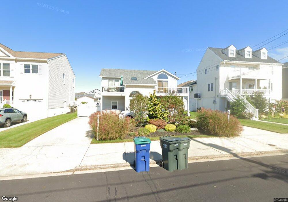
153 10th St S Brigantine, NJ 08203
Estimated Value: $698,000 - $1,043,000
6
Beds
3
Baths
2,340
Sq Ft
$386/Sq Ft
Est. Value
About This Home
This home is located at 153 10th St S, Brigantine, NJ 08203 and is currently estimated at $903,975, approximately $386 per square foot. 153 10th St S is a home located in Atlantic County with nearby schools including Brigantine Elementary School.
Ownership History
Date
Name
Owned For
Owner Type
Purchase Details
Closed on
Aug 18, 2011
Sold by
Snyder Michael R and Snyder Sandra E
Bought by
Flocco Vera
Current Estimated Value
Home Financials for this Owner
Home Financials are based on the most recent Mortgage that was taken out on this home.
Original Mortgage
$297,500
Outstanding Balance
$203,666
Interest Rate
4.33%
Mortgage Type
New Conventional
Estimated Equity
$700,309
Purchase Details
Closed on
Dec 5, 2006
Sold by
Snyder Michael R and Snyder Sandra E
Bought by
Snyder Michael R and Snyder Sandra E
Purchase Details
Closed on
Feb 10, 2003
Sold by
Vinicur Arlene
Bought by
Snyder Michael and Snyder Sandra
Purchase Details
Closed on
Feb 5, 1996
Sold by
Snyder Lawrence and Snyder Verna
Bought by
Snyder Michael R and Snyder Sandra E
Purchase Details
Closed on
Nov 20, 1989
Sold by
Snyder Lawrence Verna and Snyder Vinicur,A
Bought by
Snyder Lawrence Verna and Snyder Vinicur,A
Create a Home Valuation Report for This Property
The Home Valuation Report is an in-depth analysis detailing your home's value as well as a comparison with similar homes in the area
Home Values in the Area
Average Home Value in this Area
Purchase History
| Date | Buyer | Sale Price | Title Company |
|---|---|---|---|
| Flocco Vera | $355,000 | Fidelity National Title | |
| Snyder Michael R | -- | None Available | |
| Snyder Michael | -- | -- | |
| Snyder Michael R | -- | -- | |
| Snyder Michael R | -- | -- | |
| Snyder Lawrence Verna | -- | -- |
Source: Public Records
Mortgage History
| Date | Status | Borrower | Loan Amount |
|---|---|---|---|
| Open | Flocco Vera | $297,500 |
Source: Public Records
Tax History
| Year | Tax Paid | Tax Assessment Tax Assessment Total Assessment is a certain percentage of the fair market value that is determined by local assessors to be the total taxable value of land and additions on the property. | Land | Improvement |
|---|---|---|---|---|
| 2025 | $7,469 | $397,300 | $215,000 | $182,300 |
| 2024 | $7,469 | $397,300 | $215,000 | $182,300 |
Source: Public Records
Map
Nearby Homes
- 150 9th St S
- 222 8th St S
- 159 Sheridan Square
- 250 8th St S
- 1306 Bayshore Ave
- 468 W Shore Dr
- 713 W Brigantine Ave
- 900 W Brigantine Ave
- 1000 W Brigantine Ave Unit 4
- 800 W Brigantine Ave Unit 217
- 600 W Brigantine Ave Unit 112
- 209 Bayshore Ave
- 305 Beach Ave W Unit A and B
- 321 6th St S Unit 2
- 321 6th St S Unit 8
- 313 W Brigantine Ave Unit 8
- 303 Lafayette Place
- 116 Bayshore Ave
- 300 W Brigantine Ave Unit 103
- 1600 W Brigantine Ave
Your Personal Tour Guide
Ask me questions while you tour the home.