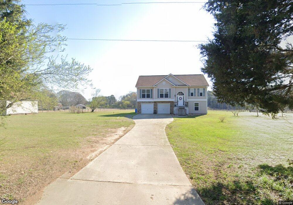
153 Popham Rd Taylorsville, GA 30178
Estimated Value: $320,000 - $430,000
3
Beds
2
Baths
1,976
Sq Ft
$191/Sq Ft
Est. Value
About This Home
This home is located at 153 Popham Rd, Taylorsville, GA 30178 and is currently estimated at $377,274, approximately $190 per square foot. 153 Popham Rd is a home located in Bartow County with nearby schools including Taylorsville Elementary School, Woodland Middle School, and Woodland High School.
Ownership History
Date
Name
Owned For
Owner Type
Purchase Details
Closed on
Jul 18, 2013
Sold by
Debroux Louis E
Bought by
Debroux Louis E and Debroux Jennifer
Current Estimated Value
Home Financials for this Owner
Home Financials are based on the most recent Mortgage that was taken out on this home.
Original Mortgage
$105,800
Outstanding Balance
$25,062
Interest Rate
3.96%
Mortgage Type
New Conventional
Estimated Equity
$352,212
Create a Home Valuation Report for This Property
The Home Valuation Report is an in-depth analysis detailing your home's value as well as a comparison with similar homes in the area
Home Values in the Area
Average Home Value in this Area
Purchase History
| Date | Buyer | Sale Price | Title Company |
|---|---|---|---|
| Debroux Louis E | -- | -- |
Source: Public Records
Mortgage History
| Date | Status | Borrower | Loan Amount |
|---|---|---|---|
| Open | Debroux Louis E | $105,800 |
Source: Public Records
Tax History Compared to Growth
Tax History
| Year | Tax Paid | Tax Assessment Tax Assessment Total Assessment is a certain percentage of the fair market value that is determined by local assessors to be the total taxable value of land and additions on the property. | Land | Improvement |
|---|---|---|---|---|
| 2024 | $2,717 | $118,223 | $11,161 | $107,062 |
| 2023 | $2,717 | $92,898 | $11,516 | $81,382 |
| 2022 | $1,576 | $68,630 | $10,924 | $57,706 |
| 2021 | $1,655 | $68,630 | $10,924 | $57,706 |
| 2020 | $1,830 | $71,630 | $11,402 | $60,228 |
| 2019 | $1,535 | $60,280 | $5,440 | $54,840 |
| 2018 | $1,540 | $60,280 | $5,440 | $54,840 |
| 2017 | $1,548 | $60,280 | $5,440 | $54,840 |
| 2016 | $1,337 | $52,400 | $5,440 | $46,960 |
| 2015 | $1,340 | $52,400 | $5,440 | $46,960 |
| 2014 | -- | $52,400 | $5,440 | $46,960 |
| 2013 | -- | $48,040 | $12,120 | $35,920 |
Source: Public Records
Map
Nearby Homes
- 0 Popham Rd Unit 7661846
- 0 Popham Rd Unit 10587111
- 0 Popham Rd Unit 22620358
- 84 Popham Rd
- 129 Miller Farm Rd
- 77 Popham Rd
- 24 Applewood Ln
- 0 Two Gun Bailey Rd Unit 7298610
- 0 Taylorsville Macedonia Rd Unit 24327696
- 367 Big Pond Rd
- 1801 Old Alabama Rd
- 37 Jackson Road South W
- 2 Two Gun Bailey Rd
- 0 Big Pond Road South W
- 169 Williams Rd
- 22 Ravenfield Rd
- 1594 Old Alabama Rd
- Tract1 Big Pond Rd
- 18 Adair Dr
- 167 Iron Hill Rd
- 193 Popham Rd
- 155 Popham Rd
- 0 Popham Rd Unit 7334485
- 0 Popham Rd Unit 8857850
- 0 Popham Rd Unit 8554891
- 0 Popham Rd Unit 8600847
- 0 Popham Rd Unit 7314222
- 0 Popham Rd Unit 3196522
- 0 Popham Rd Unit 3106759
- 1460 Taylorsville Macedonia Rd
- 159 Popham Rd
- 1470 Taylorsville Macedonia Rd
- 1498 Taylorsville Macedonia Rd
- 1514 Taylorsville Macedonia Rd
- 121 Popham Rd
- 1440 Taylorsville Macedonia Rd
- 115 Popham Rd
- 155B Popham Rd
- 176 Popham Rd