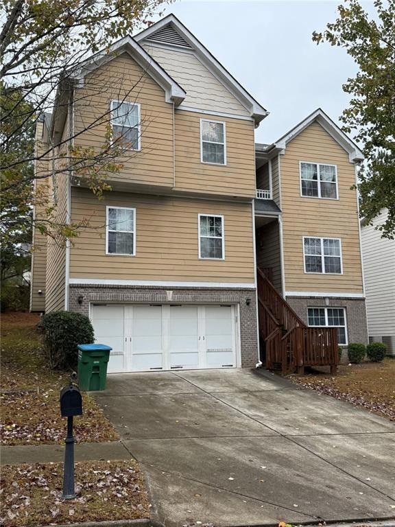
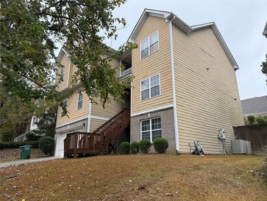
1530 Stewart Ridge Dr Buford, GA 30518
Estimated payment $3,159/month
Highlights
- Oversized primary bedroom
- Traditional Architecture
- Great Room
- White Oak Elementary School Rated A
- Wood Flooring
- Private Yard
About This Home
Nestled in a quiet location just minutes from breathtaking Lake Sidney Lanier, this well-maintained 5-bedroom, 2.5-bathroom home offers a perfect blend of comfort, elegance, and functionality. With 3 levels of living space, including a fully unfinished 1,500 sq ft basement currently set up as a home gym, but already stubbed for 2 more bedrooms along with an additional living space. This property is ideal for families seeking both relaxation and an active lifestyle.
Home Details
Home Type
- Single Family
Est. Annual Taxes
- $4,705
Year Built
- Built in 2009
Lot Details
- 6,011 Sq Ft Lot
- Lot Dimensions are 60x98x67x98
- Private Yard
- Back and Front Yard
Parking
- 2 Car Garage
Home Design
- Traditional Architecture
- Slab Foundation
- Composition Roof
- Vinyl Siding
Interior Spaces
- 3-Story Property
- Coffered Ceiling
- Tray Ceiling
- Ceiling height of 9 feet on the main level
- Ceiling Fan
- Fireplace With Gas Starter
- Insulated Windows
- Family Room with Fireplace
- Great Room
- Formal Dining Room
- Home Gym
- Fire and Smoke Detector
- Laundry Room
Kitchen
- Eat-In Kitchen
- Self-Cleaning Oven
- Electric Range
- Microwave
- Dishwasher
- Laminate Countertops
- Wood Stained Kitchen Cabinets
Flooring
- Wood
- Carpet
Bedrooms and Bathrooms
- Oversized primary bedroom
- Dual Vanity Sinks in Primary Bathroom
- Separate Shower in Primary Bathroom
Basement
- Basement Fills Entire Space Under The House
- Stubbed For A Bathroom
Schools
- Sycamore Elementary School
- Lanier Middle School
- North Gwinnett High School
Utilities
- Forced Air Heating and Cooling System
- Underground Utilities
- 220 Volts
- Electric Water Heater
Additional Features
- Energy-Efficient Insulation
- Rear Porch
Community Details
- Stewart Ridge Subdivision
Listing and Financial Details
- Home warranty included in the sale of the property
- Tax Block A
Map
Home Values in the Area
Average Home Value in this Area
Tax History
| Year | Tax Paid | Tax Assessment Tax Assessment Total Assessment is a certain percentage of the fair market value that is determined by local assessors to be the total taxable value of land and additions on the property. | Land | Improvement |
|---|---|---|---|---|
| 2025 | $4,559 | $228,800 | $40,000 | $188,800 |
| 2024 | $4,705 | $180,160 | $34,800 | $145,360 |
| 2023 | $4,705 | $130,320 | $22,000 | $108,320 |
| 2022 | $3,638 | $130,320 | $22,000 | $108,320 |
| 2021 | $3,192 | $106,240 | $16,000 | $90,240 |
| 2020 | $3,216 | $106,240 | $16,000 | $90,240 |
| 2019 | $3,145 | $106,240 | $16,000 | $90,240 |
| 2018 | $3,150 | $106,240 | $16,000 | $90,240 |
| 2016 | $2,316 | $66,840 | $11,200 | $55,640 |
| 2015 | $2,336 | $66,840 | $11,200 | $55,640 |
| 2014 | -- | $66,840 | $11,200 | $55,640 |
Purchase History
| Date | Type | Sale Price | Title Company |
|---|---|---|---|
| Warranty Deed | -- | -- | |
| Quit Claim Deed | -- | -- | |
| Warranty Deed | $165,000 | -- | |
| Deed | $141,500 | -- | |
| Foreclosure Deed | $163,906 | -- |
Mortgage History
| Date | Status | Loan Amount | Loan Type |
|---|---|---|---|
| Previous Owner | $22,500 | New Conventional | |
| Previous Owner | $152,005 | FHA | |
| Previous Owner | $141,500 | No Value Available |
Source: First Multiple Listing Service (FMLS)
MLS Number: 7682801
APN: 7-351-110
Disclaimer: Certain information contained herein is derived from information provided by parties other than Homes.com. All information provided is deemed reliable, but is not guaranteed to be accurate and should be independently verified.
![]() Listings identified with the FMLS IDX logo come from FMLS and are held by brokerage firms other than the owner of this website. The listing brokerage is identified in any listing details. Information is deemed reliable but is not guaranteed. If you believe any FMLS listing contains material that infringes your copyrighted work please visit www.fmls.com/dmca to review our DMCA policy and learn how to submit a takedown request. © 2025 First Multiple Listing Service, Inc.
Listings identified with the FMLS IDX logo come from FMLS and are held by brokerage firms other than the owner of this website. The listing brokerage is identified in any listing details. Information is deemed reliable but is not guaranteed. If you believe any FMLS listing contains material that infringes your copyrighted work please visit www.fmls.com/dmca to review our DMCA policy and learn how to submit a takedown request. © 2025 First Multiple Listing Service, Inc.
- 6351 Stewart Ridge Walk
- 6220 Stewart Rd
- 6049 Cove Park Dr
- 6054 Stewart Rd
- 948 Lanier Springs Dr
- 816 Dodd Trail Unit 172
- 1403 Sparkling Cove Dr
- 1060 Crescent Ridge Dr
- 1585 Jimmy Dodd Rd
- 1729 Rowland Pass
- 6131 Sparkling Cove Ln
- 1218 Lanier Springs Dr
- 1183 Lanier Springs Dr
- Hampstead Plan at Arbors at Richland Creek
- Lancaster Plan at Arbors at Richland Creek
- Savoy Plan at Arbors at Richland Creek
- 1705 Ambercrest Place
- 1260 Magellan Dr
- 6180 Misty Hill Ln
- 5108 City Walk Dr
- 1175 Riverside Trace
- 2075 Pine Tree Dr
- 1201 Bavarian Wood Close
- 6036 Barker Landing NE Unit ID1254415P
- 5670 Winter Bluff Way
- 6046 Barker Landing NE Unit ID1254396P
- 6009 Mock Ives Ct NE Unit ID1341828P
- 6066 Barker Landing NE Unit ID1254400P
- 1810 Patrick Mill Place NE
- 5620 Sycamore Rd
- 5986 Trail Hikes Dr Unit ID1254386P
- 1049 Megan Ct
- 5539 Hopper Dr
- 5530 Little Mill Rd
- 1030 Sycamore Summit
- 738 Austin Creek Dr
- 1586 Garden View Dr
- 1905 Barnett W Ct NE
