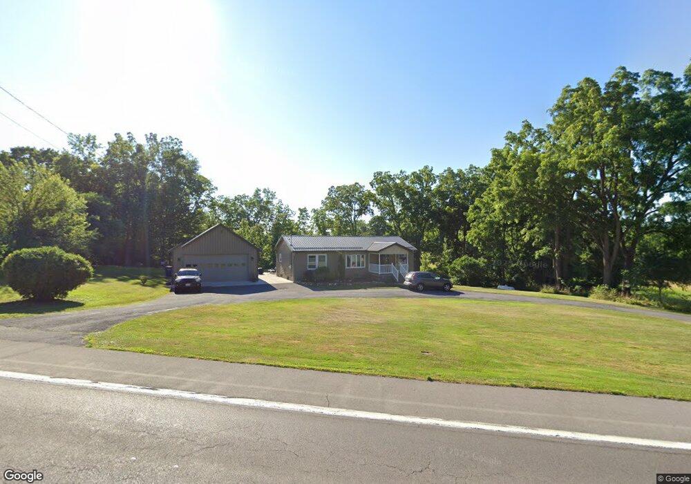
1531 State Route 31 Port Byron, NY 13140
Estimated Value: $151,000 - $206,500
3
Beds
2
Baths
1,152
Sq Ft
$150/Sq Ft
Est. Value
About This Home
This home is located at 1531 State Route 31, Port Byron, NY 13140 and is currently estimated at $173,375, approximately $150 per square foot. 1531 State Route 31 is a home located in Cayuga County with nearby schools including A.A. Gates Elementary School and Port Byron Senior High School.
Ownership History
Date
Name
Owned For
Owner Type
Purchase Details
Closed on
Sep 30, 2004
Sold by
Douglas Cook
Bought by
Ware John
Current Estimated Value
Purchase Details
Closed on
Dec 21, 1998
Sold by
Guidone Thomas L and Guidone Eugena J
Bought by
Cook Douglas E
Create a Home Valuation Report for This Property
The Home Valuation Report is an in-depth analysis detailing your home's value as well as a comparison with similar homes in the area
Home Values in the Area
Average Home Value in this Area
Purchase History
| Date | Buyer | Sale Price | Title Company |
|---|---|---|---|
| Ware John | $90,000 | Howard Clark | |
| Cook Douglas E | $69,000 | -- |
Source: Public Records
Tax History Compared to Growth
Tax History
| Year | Tax Paid | Tax Assessment Tax Assessment Total Assessment is a certain percentage of the fair market value that is determined by local assessors to be the total taxable value of land and additions on the property. | Land | Improvement |
|---|---|---|---|---|
| 2024 | $3,005 | $100,300 | $14,000 | $86,300 |
| 2023 | $3,484 | $100,300 | $14,000 | $86,300 |
| 2022 | $3,590 | $100,300 | $14,000 | $86,300 |
| 2021 | $3,679 | $100,300 | $14,000 | $86,300 |
| 2020 | $2,734 | $89,900 | $14,000 | $75,900 |
| 2019 | $1,451 | $89,900 | $14,000 | $75,900 |
| 2018 | $2,724 | $89,900 | $14,000 | $75,900 |
| 2017 | $2,686 | $89,900 | $14,000 | $75,900 |
| 2016 | $2,630 | $89,900 | $14,000 | $75,900 |
| 2015 | -- | $81,200 | $14,000 | $67,200 |
| 2014 | -- | $81,200 | $14,000 | $67,200 |
Source: Public Records
Map
Nearby Homes
- 1 Curtis St
- 5 Canal St
- 11 Canal St
- 134 Main St
- 179 Main St
- 1756 New York Central Rd
- 7959 State Street Rd
- 8089 State Route 90
- 8129 High St
- 1274 Haiti Rd
- 7410 Rice Rd
- 7639 State Street Rd
- 2653 Washington St
- 2659 Tanner Rd
- 9762 State Route 38
- 8779 South St
- 2736 E Brutus St
- 8914 Jackson St
- 7514 State Street Rd
- 2732 Green St
- 1525 State Route 31
- 1532 State Route 31
- 1528 State Route 31
- 8526 Baptist Hill Rd
- 1546 State Route 31
- 1547 State Route 31
- 1518 State Route 31
- 1512 State Route 31
- 1549 State Route 31
- 8518 Baptist Hill Rd
- 1504 State Route 31
- 1554 State Route 31
- 8502 Baptist Hill Rd
- 1561 State Route 31
- 8484 Baptist Hill Rd
- 1566 State Route 31
- 49 King St
- 61 King St
- 73 King St
- 0 King St