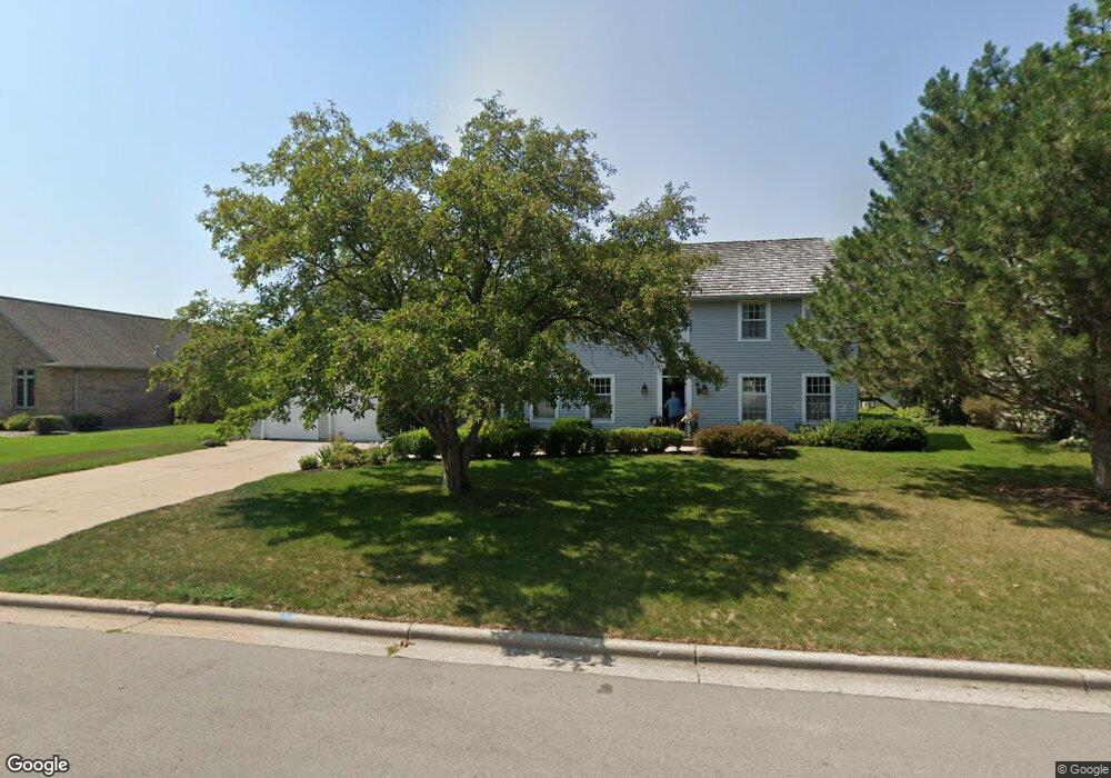
1532 Fox Ridge Ct de Pere, WI 54115
Estimated Value: $456,308 - $595,000
4
Beds
3
Baths
2,800
Sq Ft
$180/Sq Ft
Est. Value
About This Home
This home is located at 1532 Fox Ridge Ct, de Pere, WI 54115 and is currently estimated at $505,327, approximately $180 per square foot. 1532 Fox Ridge Ct is a home located in Brown County with nearby schools including Westwood Elementary School, West De Pere Middle School, and West De Pere High School.
Ownership History
Date
Name
Owned For
Owner Type
Purchase Details
Closed on
Mar 31, 2005
Sold by
Reichert Thomas D and Reichert Christine A
Bought by
Hartjes Jeff A and Hartjes Charity A
Current Estimated Value
Home Financials for this Owner
Home Financials are based on the most recent Mortgage that was taken out on this home.
Original Mortgage
$258,400
Outstanding Balance
$132,739
Interest Rate
5.71%
Mortgage Type
Fannie Mae Freddie Mac
Estimated Equity
$372,588
Purchase Details
Closed on
May 15, 1998
Sold by
Imig Robert A and Imig Patricia L
Bought by
Reichert Thomas D and Reichert Christine A
Home Financials for this Owner
Home Financials are based on the most recent Mortgage that was taken out on this home.
Original Mortgage
$134,000
Interest Rate
7.17%
Create a Home Valuation Report for This Property
The Home Valuation Report is an in-depth analysis detailing your home's value as well as a comparison with similar homes in the area
Home Values in the Area
Average Home Value in this Area
Purchase History
| Date | Buyer | Sale Price | Title Company |
|---|---|---|---|
| Hartjes Jeff A | $272,000 | Bay Title & Abstract Inc | |
| Reichert Thomas D | $214,000 | -- |
Source: Public Records
Mortgage History
| Date | Status | Borrower | Loan Amount |
|---|---|---|---|
| Open | Hartjes Jeff A | $258,400 | |
| Previous Owner | Reichert Thomas D | $134,000 |
Source: Public Records
Tax History Compared to Growth
Tax History
| Year | Tax Paid | Tax Assessment Tax Assessment Total Assessment is a certain percentage of the fair market value that is determined by local assessors to be the total taxable value of land and additions on the property. | Land | Improvement |
|---|---|---|---|---|
| 2024 | $7,111 | $454,500 | $44,500 | $410,000 |
| 2023 | $6,743 | $399,600 | $44,500 | $355,100 |
| 2022 | $6,729 | $354,300 | $44,500 | $309,800 |
| 2021 | $5,733 | $315,700 | $37,100 | $278,600 |
| 2020 | $5,695 | $291,600 | $37,100 | $254,500 |
| 2019 | $5,477 | $283,000 | $37,100 | $245,900 |
| 2018 | $5,257 | $262,800 | $37,100 | $225,700 |
| 2017 | $4,818 | $234,400 | $37,100 | $197,300 |
| 2016 | $4,840 | $234,400 | $37,100 | $197,300 |
| 2015 | $4,939 | $228,000 | $37,100 | $190,900 |
| 2014 | $4,965 | $228,000 | $37,100 | $190,900 |
| 2013 | $4,965 | $228,000 | $37,100 | $190,900 |
Source: Public Records
Map
Nearby Homes
- 1410 S 7th St
- 235 Autumn Dr
- 1509 S 7th St
- 1734 Revere Trail
- 806 4th St
- 717 4th St
- 0 N Stellita Cir Unit 50263856
- 0 N Stellita Cir Unit 50263853
- 2080 Greenleaf Rd
- 978 Saint Anthony Dr Unit 2
- 978 Saint Anthony Dr Unit 980
- 634 Grant St
- 1002 Aldrin St
- 1208 Meadow View Ln
- 830 S Superior St Unit 832
- 1275 Carmen Ct
- 555 Main Ave Unit 110
- 555 Main Ave Unit 104
- 555 Main Ave Unit 111
- 555 Main Ave Unit 206
- 1526 Fox Ridge Ct
- 1538 Fox Ridge Ct
- 1531 Lost Dauphin Rd
- 1525 Lost Dauphin Rd
- 250 Fox Ridge Ct
- 1520 Fox Ridge Ct
- 1519 Lost Dauphin Rd
- 1535 Fox Ridge Ct
- 1514 Fox Ridge Ct
- 1550 Fox Ridge Ct
- 1513 Lost Dauphin Rd
- 1543 Fox Ridge Ct
- 249 Fox Ridge Ct
- 1551 Fox Ridge Ct
- 1507 Lost Dauphin Rd
- 1508 Fox Ridge Ct
- 1556 Fox Ridge Ct
- 1515 Fox Ridge Ct
- 1605 Lost Dauphin Rd
- 1417 Lost Dauphin Rd