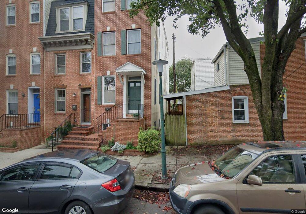
1533 Byrd St Baltimore, MD 21230
Riverside NeighborhoodEstimated Value: $405,000 - $441,929
4
Beds
2
Baths
--
Sq Ft
1,742
Sq Ft Lot
About This Home
This home is located at 1533 Byrd St, Baltimore, MD 21230 and is currently estimated at $423,465. 1533 Byrd St is a home located in Baltimore City with nearby schools including Thomas Johnson Elementary School, Booker T. Washington Middle School, and Digital Harbor High School.
Ownership History
Date
Name
Owned For
Owner Type
Purchase Details
Closed on
Dec 15, 2004
Sold by
Balodis Ivars
Bought by
Balodis Ivars P and Balodis Patricia
Current Estimated Value
Purchase Details
Closed on
Aug 26, 2004
Sold by
Balodis Ivars
Bought by
Balodis Ivars P and Balodis Patricia
Purchase Details
Closed on
Sep 12, 2000
Sold by
Lotto Kristin S
Bought by
Balodis Ivars
Purchase Details
Closed on
Oct 15, 1997
Sold by
Feehely Lawrence L
Bought by
Lotto Kristin S and Balodis Ivars P
Create a Home Valuation Report for This Property
The Home Valuation Report is an in-depth analysis detailing your home's value as well as a comparison with similar homes in the area
Home Values in the Area
Average Home Value in this Area
Purchase History
| Date | Buyer | Sale Price | Title Company |
|---|---|---|---|
| Balodis Ivars P | -- | -- | |
| Balodis Ivars P | -- | -- | |
| Balodis Ivars | -- | -- | |
| Lotto Kristin S | $12,000 | -- |
Source: Public Records
Tax History
| Year | Tax Paid | Tax Assessment Tax Assessment Total Assessment is a certain percentage of the fair market value that is determined by local assessors to be the total taxable value of land and additions on the property. | Land | Improvement |
|---|---|---|---|---|
| 2025 | $2,971 | $400,467 | -- | -- |
| 2024 | $2,971 | $395,333 | -- | -- |
| 2023 | $2,851 | $390,200 | $80,000 | $310,200 |
| 2022 | $2,703 | $384,267 | $0 | $0 |
| 2021 | $8,929 | $378,333 | $0 | $0 |
| 2020 | $2,485 | $372,400 | $80,000 | $292,400 |
| 2019 | $2,361 | $372,400 | $80,000 | $292,400 |
| 2018 | $2,363 | $372,400 | $80,000 | $292,400 |
| 2017 | $2,339 | $378,700 | $0 | $0 |
| 2016 | $2,278 | $361,900 | $0 | $0 |
| 2015 | $2,278 | $345,100 | $0 | $0 |
| 2014 | $2,278 | $328,300 | $0 | $0 |
Source: Public Records
Map
Nearby Homes
- 1523 William St
- 1513 Byrd St
- 214 E Fort Ave
- 1520 Byrd St
- 1519 Henry St
- 1519 Marshall St
- 405 E Clement St
- 1720 Byrd St
- 1601 Marshall St
- 1436 Light St
- 1434 Light St
- 442 E Fort Ave
- 1520 Marshall St
- 232 E Barney St
- 230 E Barney St
- 117 Bloomsberry St
- 132 E Gittings St
- 130 E Barney St
- 27 Birckhead St
- 1271 Battery Ave
- 1531 Byrd St
- 1529 Byrd St
- 126 E Randall St
- 124 E Randall St
- 128 E Randall St
- 122 E Randall St
- 130 E Randall St
- 1527 Byrd St
- 1525 Byrd St
- 120 E Randall St
- 132 E Randall St
- 118 E Randall St
- 134 E Randall St
- 1523 Byrd St
- 116 E Randall St
- 1521 Byrd St
- 136 E Randall St
- 1519 Byrd St
- 1517 Byrd St
- 1536 William St
Your Personal Tour Guide
Ask me questions while you tour the home.