Estimated Value: $493,565 - $564,000
3
Beds
2
Baths
1,653
Sq Ft
$316/Sq Ft
Est. Value
About This Home
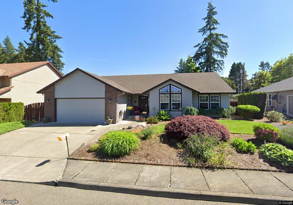
This home is located at 1533 NE 19th Loop, Canby, OR 97013 and is currently estimated at $522,641, approximately $316 per square foot. 1533 NE 19th Loop is a home located in Clackamas County with nearby schools including Josefa L. Sambrano Elementary School, William Knight Elementary School, and Baker Prairie Middle School.
Ownership History
Date
Name
Owned For
Owner Type
Purchase Details
Closed on
Jun 18, 1998
Sold by
Mclaren Merle S
Bought by
Hill Darla Jeanne
Current Estimated Value
Purchase Details
Closed on
May 16, 1995
Sold by
Andreco Ltd
Bought by
Mclaren Merle S and Mclaren Darla J
Home Financials for this Owner
Home Financials are based on the most recent Mortgage that was taken out on this home.
Original Mortgage
$110,000
Interest Rate
8.51%
Create a Home Valuation Report for This Property
The Home Valuation Report is an in-depth analysis detailing your home's value as well as a comparison with similar homes in the area
Home Values in the Area
Average Home Value in this Area
Purchase History
| Date | Buyer | Sale Price | Title Company |
|---|---|---|---|
| Hill Darla Jeanne | -- | -- | |
| Mclaren Merle S | $155,500 | Chicago Title |
Source: Public Records
Mortgage History
| Date | Status | Borrower | Loan Amount |
|---|---|---|---|
| Previous Owner | Mclaren Merle S | $110,000 |
Source: Public Records
Tax History Compared to Growth
Tax History
| Year | Tax Paid | Tax Assessment Tax Assessment Total Assessment is a certain percentage of the fair market value that is determined by local assessors to be the total taxable value of land and additions on the property. | Land | Improvement |
|---|---|---|---|---|
| 2025 | $5,270 | $297,470 | -- | -- |
| 2024 | $5,122 | $288,806 | -- | -- |
| 2023 | $5,122 | $280,395 | $0 | $0 |
| 2022 | $4,712 | $272,229 | $0 | $0 |
| 2021 | $4,537 | $264,300 | $0 | $0 |
| 2020 | $4,456 | $256,602 | $0 | $0 |
| 2019 | $4,243 | $249,129 | $0 | $0 |
| 2018 | $4,149 | $241,873 | $0 | $0 |
| 2017 | $4,043 | $234,828 | $0 | $0 |
| 2016 | $3,908 | $227,988 | $0 | $0 |
| 2015 | $3,774 | $221,348 | $0 | $0 |
| 2014 | $3,666 | $214,901 | $0 | $0 |
Source: Public Records
Map
Nearby Homes
- 1552 NE 19th Loop
- 1422 NE 18th Place
- 1620 N Sweetgum St
- 1200 NE Territorial Rd Unit 93
- 1947 NE 21st Ave
- 1009 NE 17th Ave
- 1750 N Oak St
- 878 NE 17th Ave
- 952 NE 17th Ave
- 947 NE 17th Ave
- 2125 NE Spitz Rd
- 2123 NE Spitz Rd
- 844 NE 17th Ave
- 838 NE 17th Ave
- 853 NE 17th Ave
- 832 NE 17th Ave
- 860 NE 14th Ave
- 1558 NE 10th Place
- 660 NE 20th Ave
- 1751 N Laurelwood Loop
- 1555 NE 19th Loop
- 1501 NE 19th Loop
- 1850 N Redwood St
- 1526 NE 19th Loop
- 1567 NE 19th Loop
- 1508 NE 19th Loop
- 1581 NE 19th Loop
- 1464 NE 18th Place
- 1519 NE 19th Loop
- 1547 NE 19th Loop
- 1468 NE 18th Place
- 1507 NE 19th Loop
- 1579 NE 19th Loop
- 1583 NE 19th Loop
- 1580 NE 19th Loop
- 1582 NE 19th Loop
- 1444 NE 18th Place
- 1901 N Redwood St
- 1794 N Redwood St
- 1442 NE 18th Place