Estimated Value: $219,372 - $297,000
3
Beds
3
Baths
1,106
Sq Ft
$230/Sq Ft
Est. Value
About This Home
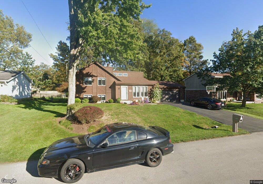
This home is located at 1537 Adak Ave, Lima, OH 45805 and is currently estimated at $254,093, approximately $229 per square foot. 1537 Adak Ave is a home located in Allen County with nearby schools including Maplewood Elementary School, Elmwood Elementary School, and Shawnee Middle School.
Ownership History
Date
Name
Owned For
Owner Type
Purchase Details
Closed on
May 22, 2023
Sold by
Lane Babe M and Lane Stephanie M
Bought by
Lane Babe Michael and Lane Babe Michael
Current Estimated Value
Purchase Details
Closed on
Nov 21, 1997
Sold by
Irwin Guy
Bought by
Lane Babe and Lane Stephanie
Home Financials for this Owner
Home Financials are based on the most recent Mortgage that was taken out on this home.
Original Mortgage
$86,307
Interest Rate
7.38%
Mortgage Type
New Conventional
Purchase Details
Closed on
Dec 20, 1996
Sold by
Monroe Robert
Bought by
Irwin Guy and Irwin Tiffany
Home Financials for this Owner
Home Financials are based on the most recent Mortgage that was taken out on this home.
Original Mortgage
$76,500
Interest Rate
7.74%
Mortgage Type
New Conventional
Purchase Details
Closed on
Mar 12, 1986
Bought by
Monroe Robert F
Create a Home Valuation Report for This Property
The Home Valuation Report is an in-depth analysis detailing your home's value as well as a comparison with similar homes in the area
Home Values in the Area
Average Home Value in this Area
Purchase History
| Date | Buyer | Sale Price | Title Company |
|---|---|---|---|
| Lane Babe Michael | -- | None Listed On Document | |
| Lane Babe | $90,850 | -- | |
| Irwin Guy | $85,000 | -- | |
| Monroe Robert F | $66,000 | -- |
Source: Public Records
Mortgage History
| Date | Status | Borrower | Loan Amount |
|---|---|---|---|
| Previous Owner | Lane Babe | $86,307 | |
| Previous Owner | Irwin Guy | $76,500 |
Source: Public Records
Tax History Compared to Growth
Tax History
| Year | Tax Paid | Tax Assessment Tax Assessment Total Assessment is a certain percentage of the fair market value that is determined by local assessors to be the total taxable value of land and additions on the property. | Land | Improvement |
|---|---|---|---|---|
| 2024 | $2,977 | $61,120 | $8,020 | $53,100 |
| 2023 | $2,577 | $46,660 | $6,130 | $40,530 |
| 2022 | $2,597 | $46,660 | $6,130 | $40,530 |
| 2021 | $2,609 | $46,660 | $6,130 | $40,530 |
| 2020 | $1,988 | $41,200 | $5,850 | $35,350 |
| 2019 | $1,988 | $41,200 | $5,850 | $35,350 |
| 2018 | $1,916 | $41,200 | $5,850 | $35,350 |
| 2017 | $1,852 | $37,320 | $5,850 | $31,470 |
| 2016 | $1,836 | $37,320 | $5,850 | $31,470 |
| 2015 | $1,758 | $37,320 | $5,850 | $31,470 |
| 2014 | $1,758 | $35,290 | $5,710 | $29,580 |
| 2013 | $1,725 | $35,290 | $5,710 | $29,580 |
Source: Public Records
Map
Nearby Homes
- 1446 Adak Ave
- 1424 Loch Loman Way
- 1453 W Shore Dr
- 1440 Riverview Dr
- 1408 Winghaven Dr
- 3390 Spencerville Rd
- 2992 Autumn Leaves Ct
- 115 Lanes End
- 0 Colonial Ln
- 3410 Greens Rd
- 0 Springview Dr
- 2320 London Dr
- 2997 Cletus Pkwy
- 250 Squire Ln
- 00 Seriff
- 2297 June Dr
- 2635 Adgate Rd Unit 112
- 1755 Shawnee Rd Unit 207
- 3220 Fort Amanda Rd
- 1635 Tanglewood Ln