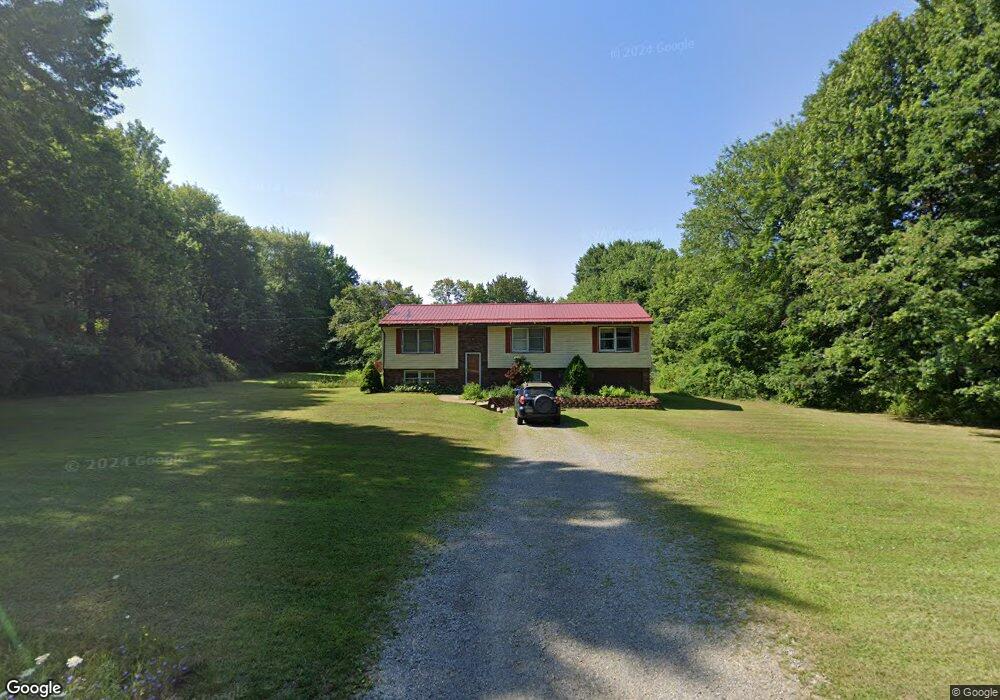
1538 Carlton Rd Carlton, PA 16311
Estimated Value: $218,000 - $271,000
4
Beds
3
Baths
2,280
Sq Ft
$103/Sq Ft
Est. Value
About This Home
This home is located at 1538 Carlton Rd, Carlton, PA 16311 and is currently estimated at $235,643, approximately $103 per square foot. 1538 Carlton Rd is a home located in Mercer County with nearby schools including Cochranton Elementary School, Cochranton Junior/Senior High School, and Carlton Amish School.
Ownership History
Date
Name
Owned For
Owner Type
Purchase Details
Closed on
May 11, 2020
Sold by
Mumford Michael R and Shelter Connie S
Bought by
Gilligan Clinton P and Gilligan Ashley J
Current Estimated Value
Home Financials for this Owner
Home Financials are based on the most recent Mortgage that was taken out on this home.
Original Mortgage
$156,000
Outstanding Balance
$138,238
Interest Rate
3.3%
Mortgage Type
VA
Estimated Equity
$97,405
Purchase Details
Closed on
Jun 21, 2008
Sold by
Sutley Lloyd Kenneth and Sutley Kristine K
Bought by
Mumford Michael R and Shetler Connie S
Home Financials for this Owner
Home Financials are based on the most recent Mortgage that was taken out on this home.
Original Mortgage
$119,200
Interest Rate
6.07%
Mortgage Type
Purchase Money Mortgage
Create a Home Valuation Report for This Property
The Home Valuation Report is an in-depth analysis detailing your home's value as well as a comparison with similar homes in the area
Home Values in the Area
Average Home Value in this Area
Purchase History
| Date | Buyer | Sale Price | Title Company |
|---|---|---|---|
| Gilligan Clinton P | $156,000 | None Available | |
| Mumford Michael R | $134,000 | None Available |
Source: Public Records
Mortgage History
| Date | Status | Borrower | Loan Amount |
|---|---|---|---|
| Open | Gilligan Clinton P | $156,000 | |
| Previous Owner | Mumford Michael R | $119,200 |
Source: Public Records
Tax History Compared to Growth
Tax History
| Year | Tax Paid | Tax Assessment Tax Assessment Total Assessment is a certain percentage of the fair market value that is determined by local assessors to be the total taxable value of land and additions on the property. | Land | Improvement |
|---|---|---|---|---|
| 2025 | $1,057 | $25,800 | $1,350 | $24,450 |
| 2024 | $1,057 | $25,800 | $1,350 | $24,450 |
| 2023 | $1,057 | $25,800 | $1,350 | $24,450 |
| 2022 | $3,202 | $25,800 | $1,350 | $24,450 |
| 2021 | $3,125 | $25,800 | $1,350 | $24,450 |
| 2020 | $3,096 | $25,800 | $1,350 | $24,450 |
| 2019 | $3,096 | $25,800 | $1,350 | $24,450 |
| 2018 | $3,053 | $25,800 | $1,350 | $24,450 |
| 2017 | $3,053 | $25,800 | $1,350 | $24,450 |
| 2016 | -- | $25,800 | $1,350 | $24,450 |
| 2015 | -- | $25,800 | $1,350 | $24,450 |
| 2014 | -- | $25,800 | $1,350 | $24,450 |
Source: Public Records
Map
Nearby Homes
- 16 Blair Ln
- 0 Donation Hill Rd Unit 24033249
- 23755 State Highway 285
- 4129 Pine Dr
- 946 Crouser School Rd
- 4260 Powell Ln
- 23078 Mallard Ln
- 315 Long Rd
- 123 Hemlock Ln
- 2687 Raymilton Rd
- 0 Two Mile Run Rd Lot Unit WP001
- 175 Phelps Rd
- 116 3rd St
- 3857 Academy St
- 567 Klein Rd
- 42 Sunol Rd
- 606 Georgetown Rd
- Deckard's Run Rd and Judson Rd
- 410 Chestnut Grove Rd
- 0 Deckards Run Rd and Judson Rd Unit 11536704
- 1532 Carlton Rd
- 1525 Carlton Rd
- 1556 Carlton Rd
- 1528 Carlton Rd
- 1555 Carlton Rd
- 1512 Carlton Rd
- 1568 Carlton Rd
- 1586 Carlton Rd
- 1490 Carlton Rd
- 1578 Carlton Rd
- 1593 Carlton Rd
- 1464 Carlton Rd
- 1602 Carlton Rd
- 1471 Carlton Rd
- 75 W Creek Rd
- 1478 Carlton Rd
- 1453 Carlton Rd
- 74 W Creek Rd
- 100 Black Rd
- 115 W Creek Rd