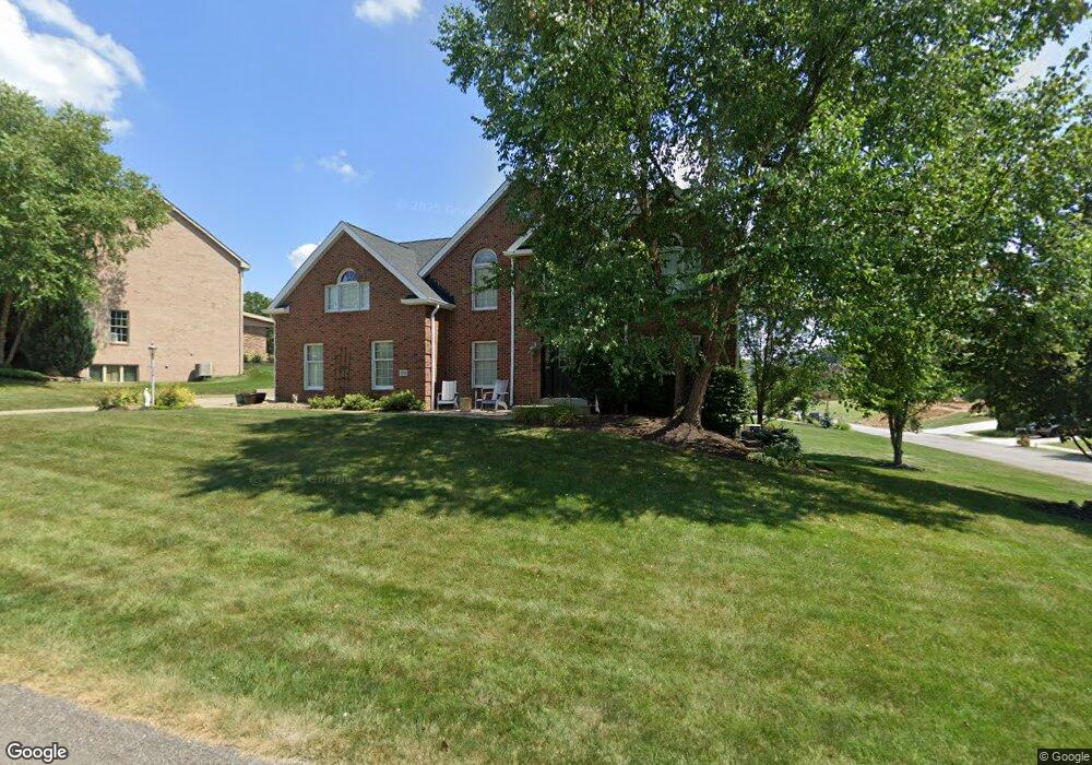
1538 Network Dr Canonsburg, PA 15317
Estimated Value: $733,000 - $797,000
5
Beds
4
Baths
2,908
Sq Ft
$265/Sq Ft
Est. Value
About This Home
This home is located at 1538 Network Dr, Canonsburg, PA 15317 and is currently estimated at $769,549, approximately $264 per square foot. 1538 Network Dr is a home located in Washington County with nearby schools including Canon-Mcmillan Senior High School.
Ownership History
Date
Name
Owned For
Owner Type
Purchase Details
Closed on
Apr 21, 2009
Sold by
Drye David E
Bought by
O'Bryan Kevin
Current Estimated Value
Home Financials for this Owner
Home Financials are based on the most recent Mortgage that was taken out on this home.
Original Mortgage
$278,000
Outstanding Balance
$175,646
Interest Rate
4.93%
Mortgage Type
New Conventional
Estimated Equity
$593,903
Purchase Details
Closed on
Feb 12, 2005
Sold by
Graziani William
Bought by
Drye David
Home Financials for this Owner
Home Financials are based on the most recent Mortgage that was taken out on this home.
Original Mortgage
$359,600
Interest Rate
5.78%
Mortgage Type
New Conventional
Purchase Details
Closed on
Feb 24, 2004
Sold by
Bachman Bldrs Inc
Bought by
Stuts Barry
Home Financials for this Owner
Home Financials are based on the most recent Mortgage that was taken out on this home.
Original Mortgage
$250,000
Interest Rate
5.62%
Mortgage Type
New Conventional
Create a Home Valuation Report for This Property
The Home Valuation Report is an in-depth analysis detailing your home's value as well as a comparison with similar homes in the area
Home Values in the Area
Average Home Value in this Area
Purchase History
| Date | Buyer | Sale Price | Title Company |
|---|---|---|---|
| O'Bryan Kevin | $417,000 | -- | |
| Drye David | $450,000 | -- | |
| Stuts Barry | $400,000 | -- |
Source: Public Records
Mortgage History
| Date | Status | Borrower | Loan Amount |
|---|---|---|---|
| Open | O'Bryan Kevin | $278,000 | |
| Previous Owner | Drye David | $359,600 | |
| Previous Owner | Stuts Barry | $250,000 |
Source: Public Records
Tax History Compared to Growth
Tax History
| Year | Tax Paid | Tax Assessment Tax Assessment Total Assessment is a certain percentage of the fair market value that is determined by local assessors to be the total taxable value of land and additions on the property. | Land | Improvement |
|---|---|---|---|---|
| 2025 | $8,583 | $509,700 | $113,000 | $396,700 |
| 2024 | $8,120 | $509,700 | $113,000 | $396,700 |
| 2023 | $8,120 | $509,700 | $113,000 | $396,700 |
| 2022 | $8,096 | $509,700 | $113,000 | $396,700 |
| 2021 | $8,096 | $509,700 | $113,000 | $396,700 |
| 2020 | $7,941 | $509,700 | $113,000 | $396,700 |
| 2019 | $7,814 | $509,700 | $113,000 | $396,700 |
| 2018 | $7,656 | $509,700 | $113,000 | $396,700 |
| 2017 | $779 | $509,700 | $113,000 | $396,700 |
| 2016 | $1,032 | $41,460 | $7,529 | $33,931 |
| 2015 | $677 | $41,460 | $7,529 | $33,931 |
| 2014 | $1,032 | $41,460 | $7,529 | $33,931 |
| 2013 | $1,032 | $41,460 | $7,529 | $33,931 |
Source: Public Records
Map
Nearby Homes
- 1582 Network Dr
- 1272 Mcewen Rd
- 1065 Skyline Dr
- 1041 Skyline Dr
- 1037 Skyline Dr
- 1033 Skyline Dr
- 1163 Mcewen Ave
- 29 Virginia Ln
- 214 Hooks Ln
- 9 Puskar Ln
- 1382 Lucia Dr
- 510 Panorama Dr
- 209 Joseph Dr
- 718 Gladden Rd
- 1521 Eagle Pointe Dr
- 520 Panorama Dr
- 107 Fairway Landings Dr
- 3016 Brookstone Dr
- 1116 Martin Dr
- 127 Fairway Landings Dr
- 1542 Network Dr
- 1542 Network Dr
- 1546 Network Dr
- 2077 Breezewood Dr
- 1537 Network Dr
- 1550 Network Dr
- 1541 Network Dr
- 2069 Breezewood Dr
- 1533 Network Dr
- 1554 Network Dr
- 1529 Network Dr
- 1013 Oak Ridge Rd
- 1551 Network Dr
- 1000 Oak Ridge Rd
- 1525 Network Dr
- 1005 Breezewood Dr
- 1558 Network Dr
- 1524 Network Dr
- 523 Breezewood Dr
- 605 Breezewood Dr