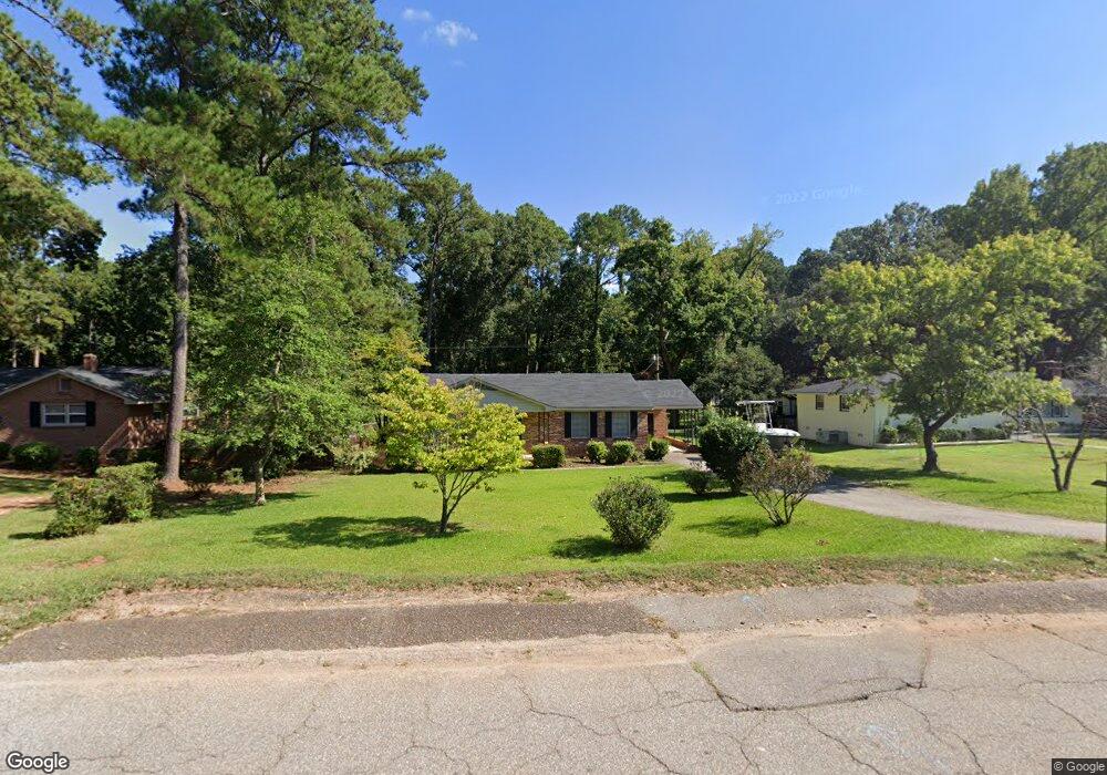
1538 Omarest Dr Columbia, SC 29210
Saint Andrews NeighborhoodEstimated Value: $185,000 - $211,000
3
Beds
2
Baths
1,582
Sq Ft
$122/Sq Ft
Est. Value
About This Home
This home is located at 1538 Omarest Dr, Columbia, SC 29210 and is currently estimated at $193,596, approximately $122 per square foot. 1538 Omarest Dr is a home located in Richland County with nearby schools including H. B. Rhame Elementary School, St. Andrews Middle School, and Columbia High School.
Ownership History
Date
Name
Owned For
Owner Type
Purchase Details
Closed on
Jan 15, 2020
Sold by
Watkins Anne B and Kayla A Watkins Revocable Trus
Bought by
Watkins Anne B and Anne B Watkins Trust
Current Estimated Value
Purchase Details
Closed on
Dec 22, 2016
Sold by
Watkins Anne B
Bought by
Watkins Anne B and Kayla A Watkins Revocable Trust
Purchase Details
Closed on
Dec 19, 2016
Sold by
Bradshaw Amy Lauren
Bought by
Watkins Anne B
Purchase Details
Closed on
Apr 30, 2013
Sold by
The Estate Of Daniel David Bradshaw Jr
Bought by
Bradshaw Lorena C
Create a Home Valuation Report for This Property
The Home Valuation Report is an in-depth analysis detailing your home's value as well as a comparison with similar homes in the area
Home Values in the Area
Average Home Value in this Area
Purchase History
| Date | Buyer | Sale Price | Title Company |
|---|---|---|---|
| Watkins Anne B | -- | None Available | |
| Watkins Anne B | -- | None Available | |
| Watkins Anne B | -- | None Available | |
| Watkins Anne B | -- | None Available | |
| Watkins Anne B | -- | None Available | |
| Bradshaw Lorena C | -- | None Available |
Source: Public Records
Tax History Compared to Growth
Tax History
| Year | Tax Paid | Tax Assessment Tax Assessment Total Assessment is a certain percentage of the fair market value that is determined by local assessors to be the total taxable value of land and additions on the property. | Land | Improvement |
|---|---|---|---|---|
| 2024 | $1,034 | $96,200 | $0 | $0 |
| 2023 | $992 | $3,344 | $0 | $0 |
| 2022 | $900 | $83,600 | $12,600 | $71,000 |
| 2021 | $889 | $3,340 | $0 | $0 |
| 2020 | $2,590 | $5,020 | $0 | $0 |
| 2019 | $2,565 | $5,020 | $0 | $0 |
| 2018 | $796 | $3,040 | $0 | $0 |
| 2017 | $780 | $3,040 | $0 | $0 |
| 2016 | $2,242 | $4,570 | $0 | $0 |
| 2015 | $759 | $3,040 | $0 | $0 |
| 2014 | $740 | $76,000 | $0 | $0 |
| 2013 | -- | $3,040 | $0 | $0 |
Source: Public Records
Map
Nearby Homes
- 201 Burbank St
- 232 Burbank St
- 112 Gateway Ln
- 1650 Omarest Dr
- 1712 Omarest Dr
- 321 Cambout St
- 1820 Omarest Dr
- 529 Cambout St
- 1510 Canal Dr
- 105 River Bluff Ct
- 214 River Bluff Way
- 1850 Atlantic Dr
- 1850 Atlantic Dr Unit 416
- 2103 Marley Dr
- 409 Huntley Way
- 1127 Shirlington Rd
- 1904 Elise Dr
- 1509 Nunamaker Dr
- 2006 Mary Hill Dr
- 517 Innsbrook Dr
- 1542 Omarest Dr
- 1532 Omarest Dr
- 1548 Omarest Dr
- 123 Kismet St
- 1539 Omarest Dr
- 1528 Omarest Dr
- 1535 Omarest Dr
- 1531 Omarest Dr
- 1535 Koulter Dr
- 115 Kismet St
- 1522 Omarest Dr
- 1600 Omarest Dr
- 1529 Koulter Dr
- 204 Burbank St
- 128 Kismet St
- 1549 Omarest Dr
- 122 Kismet St
- 1541 Koulter Dr
- 1612 Omarest Dr
- 1601 Omarest Dr