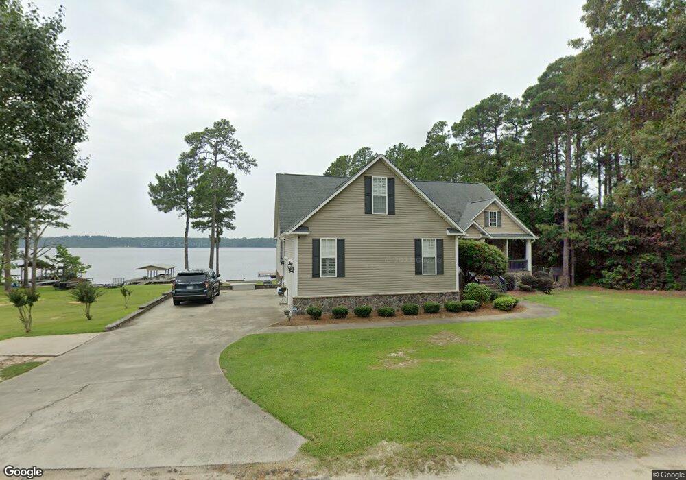
154 Ammons Ln Hartsville, SC 29550
Estimated Value: $291,060 - $501,000
--
Bed
--
Bath
3,159
Sq Ft
$129/Sq Ft
Est. Value
About This Home
This home is located at 154 Ammons Ln, Hartsville, SC 29550 and is currently estimated at $406,515, approximately $128 per square foot. 154 Ammons Ln is a home with nearby schools including McBee Elementary School, McBee High School, and New Heights Middle School.
Ownership History
Date
Name
Owned For
Owner Type
Purchase Details
Closed on
May 22, 2019
Sold by
Barfield John D and Barfield Lori A
Bought by
Barfield Lori A and Barfield Justin D
Current Estimated Value
Purchase Details
Closed on
Sep 27, 2017
Sold by
Morehead Robert George and Morehead Judy Haire
Bought by
Barfield John David and Barfield Lori Ann
Purchase Details
Closed on
May 9, 2006
Sold by
Boatwright Lynn S
Bought by
Morehead Robert George and Morehead Judy Haire
Home Financials for this Owner
Home Financials are based on the most recent Mortgage that was taken out on this home.
Original Mortgage
$240,000
Interest Rate
6.33%
Mortgage Type
Commercial
Purchase Details
Closed on
Jul 6, 2000
Sold by
Schuchter David C
Bought by
Boatwright Lynn
Create a Home Valuation Report for This Property
The Home Valuation Report is an in-depth analysis detailing your home's value as well as a comparison with similar homes in the area
Home Values in the Area
Average Home Value in this Area
Purchase History
| Date | Buyer | Sale Price | Title Company |
|---|---|---|---|
| Barfield Lori A | -- | -- | |
| Barfield John David | $250,000 | None Available | |
| Barfield John David | $250,000 | None Available | |
| Morehead Robert George | $68,000 | -- | |
| Boatwright Lynn | $65,000 | -- |
Source: Public Records
Mortgage History
| Date | Status | Borrower | Loan Amount |
|---|---|---|---|
| Previous Owner | Morehead Robert George | $240,000 |
Source: Public Records
Tax History Compared to Growth
Tax History
| Year | Tax Paid | Tax Assessment Tax Assessment Total Assessment is a certain percentage of the fair market value that is determined by local assessors to be the total taxable value of land and additions on the property. | Land | Improvement |
|---|---|---|---|---|
| 2024 | $1,591 | $12,310 | $3,000 | $9,310 |
| 2023 | $1,525 | $12,310 | $3,000 | $9,310 |
| 2022 | $1,447 | $12,310 | $3,000 | $9,310 |
| 2021 | $1,441 | $12,310 | $3,000 | $9,310 |
| 2020 | $4,432 | $12,310 | $3,000 | $9,310 |
| 2019 | $4,464 | $12,310 | $3,000 | $9,310 |
| 2018 | $4,365 | $12,310 | $3,000 | $9,310 |
| 2015 | $5,808 | $19,120 | $4,500 | $14,620 |
| 2014 | $1,526 | $19,120 | $4,500 | $14,620 |
| 2010 | -- | $15,440 | $2,720 | $12,720 |
Source: Public Records
Map
Nearby Homes
- 4211 Middendorf Rd
- TBD Sailclub Rd (Tm#164) State Rd S-13-674
- TBD Sail Club Road Tm#160 (State Rd S-13-674)
- TBD Sail Club Rd (State Rd S-13-674) Tms 162
- 000 Overflow Rd
- 165 Forest Dr
- 2600 Robinson View Dr
- 2545 Robinson View Dr
- 0 New Market Rd
- 52 Scott Pond Rd
- 0 Peace Ln
- 000 Peace Ln
- 2606 Bullard Ford Rd
- 291 Peace Ln
- 2800 Bullard Ford Rd
- 3 Harold Funderburke Ln
- TBD Regency Dr
- 212 Johnson Park Rd
- TBD 11 acres Ousleydale Rd
- TBD 8.5 Ousleydale Rd