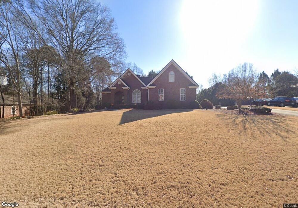
154 Brittany Rd Bogart, GA 30622
Estimated Value: $438,000 - $475,000
3
Beds
2
Baths
2,403
Sq Ft
$188/Sq Ft
Est. Value
About This Home
This home is located at 154 Brittany Rd, Bogart, GA 30622 and is currently estimated at $452,727, approximately $188 per square foot. 154 Brittany Rd is a home located in Clarke County with nearby schools including Cleveland Road Elementary School, Burney-Harris-Lyons Middle School, and Clarke Central High School.
Ownership History
Date
Name
Owned For
Owner Type
Purchase Details
Closed on
Aug 24, 2007
Sold by
Not Provided
Bought by
Saxton David B and Saxton Kimberlyn W
Current Estimated Value
Home Financials for this Owner
Home Financials are based on the most recent Mortgage that was taken out on this home.
Original Mortgage
$208,000
Outstanding Balance
$131,022
Interest Rate
6.65%
Mortgage Type
New Conventional
Estimated Equity
$321,705
Purchase Details
Closed on
Sep 10, 2002
Sold by
Trc Construction
Bought by
Porterfield Steven W and Porterfield Patricia B
Purchase Details
Closed on
Apr 19, 2002
Sold by
Willwork Llc
Bought by
Trc Construction
Create a Home Valuation Report for This Property
The Home Valuation Report is an in-depth analysis detailing your home's value as well as a comparison with similar homes in the area
Home Values in the Area
Average Home Value in this Area
Purchase History
| Date | Buyer | Sale Price | Title Company |
|---|---|---|---|
| Saxton David B | $260,000 | -- | |
| Porterfield Steven W | $205,000 | -- | |
| Trc Construction | $30,000 | -- |
Source: Public Records
Mortgage History
| Date | Status | Borrower | Loan Amount |
|---|---|---|---|
| Open | Saxton David B | $208,000 | |
| Closed | Saxton David B | $26,000 |
Source: Public Records
Tax History Compared to Growth
Tax History
| Year | Tax Paid | Tax Assessment Tax Assessment Total Assessment is a certain percentage of the fair market value that is determined by local assessors to be the total taxable value of land and additions on the property. | Land | Improvement |
|---|---|---|---|---|
| 2025 | $5,207 | $186,744 | $18,000 | $168,744 |
| 2024 | $5,207 | $178,772 | $18,000 | $160,772 |
| 2023 | $5,087 | $167,331 | $18,000 | $149,331 |
| 2022 | $4,227 | $142,510 | $18,000 | $124,510 |
| 2021 | $3,634 | $117,825 | $16,000 | $101,825 |
| 2020 | $3,524 | $114,557 | $16,000 | $98,557 |
| 2019 | $3,231 | $105,158 | $16,000 | $89,158 |
| 2018 | $3,073 | $100,514 | $16,000 | $84,514 |
| 2017 | $2,793 | $92,269 | $16,000 | $76,269 |
| 2016 | $2,716 | $90,008 | $16,000 | $74,008 |
| 2015 | $2,624 | $87,150 | $16,000 | $71,150 |
| 2014 | $2,745 | $90,606 | $16,000 | $74,606 |
Source: Public Records
Map
Nearby Homes
- 240 W Huntington Rd
- 190 W Huntington Rd
- 201 Chesterfield Rd
- 102 River Bottom Cir
- 241 Meeler Cir
- 116 Laurel Springs Dr
- 141 Mountain Laurel Run
- 637 Huntington Rd Unit B1
- 100 Hanover Dr
- 532 Huntington Rd Unit 7
- 470 Huntington Rd Unit 5
- 460 Huntington Rd
- 256 Cherokee Ridge
- 575 Vaughn Rd
- 150 Callaway Dr
- 265 Deerhill Dr
- 240 Deerfield Rd
- 215 Claystone Trace
- 115 Woodhaven St
- 144 Brittany Rd
- 164 Brittany Rd
- 0 Brittany Rd Unit Lot 4 CM902610
- 229 Imperial Way
- 157 Brittany Rd
- 189 Imperial Way
- 239 Imperial Way
- 134 Brittany Rd
- 167 Brittany Rd
- 174 Brittany Rd
- 179 Imperial Way
- 0 Imperial Way Unit CM331832
- G-2 Imperial Way
- 249 Imperial Way
- 127 Brittany Rd
- 160 Chelsea Ct
- 184 Brittany Rd
- 124 Brittany Rd
- 169 Imperial Way
- 187 Brittany Rd