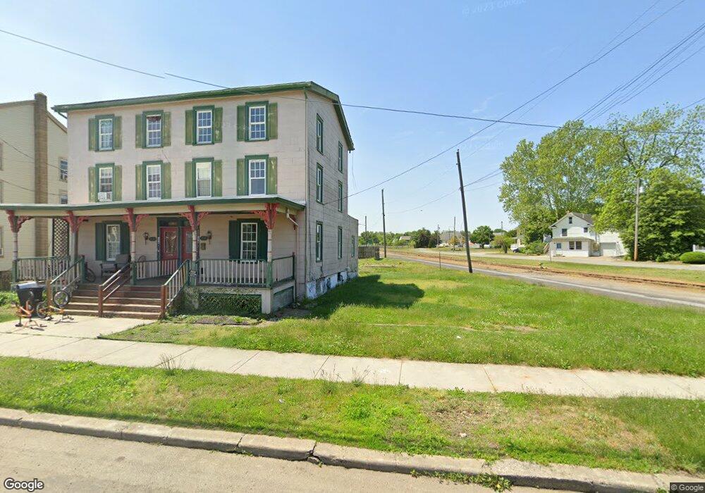
154 Broad St Unit 56 Swedesboro, NJ 08085
Estimated Value: $338,000 - $385,000
--
Bed
--
Bath
3,240
Sq Ft
$111/Sq Ft
Est. Value
About This Home
This home is located at 154 Broad St Unit 56, Swedesboro, NJ 08085 and is currently estimated at $359,024, approximately $110 per square foot. 154 Broad St Unit 56 is a home located in Gloucester County with nearby schools including Margaret C Clifford School, Gov. Charles C. Stratton School, and Gen. Charles G. Harker School.
Ownership History
Date
Name
Owned For
Owner Type
Purchase Details
Closed on
Jan 14, 2023
Sold by
Martorano Nicholas A
Bought by
Irrevocable Family Trust
Current Estimated Value
Purchase Details
Closed on
Mar 7, 2008
Sold by
Lasecki Adam E and Estate Of Laura Mae Lasecki
Bought by
Martorano Antoinette
Home Financials for this Owner
Home Financials are based on the most recent Mortgage that was taken out on this home.
Original Mortgage
$186,150
Interest Rate
5.75%
Mortgage Type
Purchase Money Mortgage
Create a Home Valuation Report for This Property
The Home Valuation Report is an in-depth analysis detailing your home's value as well as a comparison with similar homes in the area
Home Values in the Area
Average Home Value in this Area
Purchase History
| Date | Buyer | Sale Price | Title Company |
|---|---|---|---|
| Irrevocable Family Trust | $25,000 | -- | |
| Irrevocable Family Trust | $25,000 | None Listed On Document | |
| Martorano Antoinette | $219,000 | Precision Title Agency |
Source: Public Records
Mortgage History
| Date | Status | Borrower | Loan Amount |
|---|---|---|---|
| Previous Owner | Martorano Antoinette | $186,150 |
Source: Public Records
Tax History Compared to Growth
Tax History
| Year | Tax Paid | Tax Assessment Tax Assessment Total Assessment is a certain percentage of the fair market value that is determined by local assessors to be the total taxable value of land and additions on the property. | Land | Improvement |
|---|---|---|---|---|
| 2025 | $8,712 | $204,900 | $26,400 | $178,500 |
| 2024 | $8,637 | $204,900 | $26,400 | $178,500 |
| 2023 | $8,637 | $204,900 | $26,400 | $178,500 |
| 2022 | $8,618 | $204,900 | $26,400 | $178,500 |
| 2021 | $8,624 | $204,900 | $26,400 | $178,500 |
| 2020 | $8,319 | $204,900 | $26,400 | $178,500 |
| 2019 | $8,171 | $204,900 | $26,400 | $178,500 |
| 2018 | $8,251 | $204,900 | $26,400 | $178,500 |
| 2017 | $8,206 | $204,900 | $26,400 | $178,500 |
| 2016 | $8,198 | $204,900 | $26,400 | $178,500 |
| 2015 | $7,962 | $204,900 | $26,400 | $178,500 |
| 2014 | $7,123 | $194,300 | $30,100 | $164,200 |
Source: Public Records
Map
Nearby Homes
- 209 Broad St
- 414 Vanneman Ave
- 110 Franklin St
- 1602 Kings Hwy
- 122 East Ave
- 109 Chestnut St
- 26 Garwin Rd
- 1030 Auburn Rd
- 218 Dominics Ct
- 112 Jules Dr
- 48 Garwin Rd
- 2153 Route 322
- 2101 Lexington Mews
- 155 Erica Ct
- 163 Erica Ct
- 1508 Lexington Mews
- 1406 Lexington Mews
- 176 Patricia Dr
- 1801 Lexington Mews
- 114 Saratoga Ln
- 150 Broad St Unit 52
- 152 Broad St
- 200 Weatherby Ave
- 324 3rd St
- 201 Weatherby Ave
- 215 Vannaman Ave
- 215 Vanneman Ave
- 328 3rd St
- 207 Weatherby Ave
- 217 Vannaman Ave
- 208 Broad St
- 129 Broad St
- 214 Weatherby Ave
- 127 Broad St Unit M02
- 133 Allen St
- 219 Vannaman Ave
- 219 Vanneman Ave
- 211 Weatherby Ave
- 124 Broad St
- 210 Broad St Unit M01