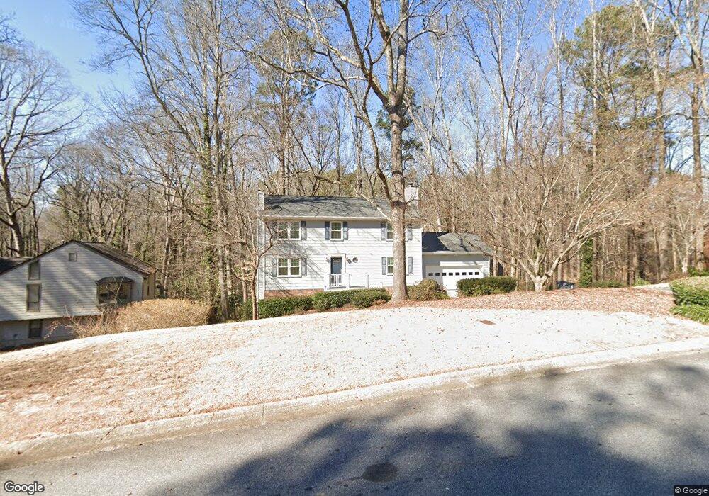
154 Newport Rd SW Lilburn, GA 30047
Estimated Value: $400,000 - $457,000
4
Beds
3
Baths
2,080
Sq Ft
$208/Sq Ft
Est. Value
About This Home
This home is located at 154 Newport Rd SW, Lilburn, GA 30047 and is currently estimated at $431,682, approximately $207 per square foot. 154 Newport Rd SW is a home located in Gwinnett County with nearby schools including Knight Elementary School, Trickum Middle School, and Parkview High School.
Ownership History
Date
Name
Owned For
Owner Type
Purchase Details
Closed on
May 6, 1994
Sold by
Hickein James W Margaret
Bought by
Stephenson Kenneth A Deborah
Current Estimated Value
Home Financials for this Owner
Home Financials are based on the most recent Mortgage that was taken out on this home.
Original Mortgage
$65,000
Interest Rate
7.81%
Create a Home Valuation Report for This Property
The Home Valuation Report is an in-depth analysis detailing your home's value as well as a comparison with similar homes in the area
Home Values in the Area
Average Home Value in this Area
Purchase History
| Date | Buyer | Sale Price | Title Company |
|---|---|---|---|
| Stephenson Kenneth A Deborah | $150,000 | -- |
Source: Public Records
Mortgage History
| Date | Status | Borrower | Loan Amount |
|---|---|---|---|
| Closed | Stephenson Kenneth A Deborah | $65,000 |
Source: Public Records
Tax History Compared to Growth
Tax History
| Year | Tax Paid | Tax Assessment Tax Assessment Total Assessment is a certain percentage of the fair market value that is determined by local assessors to be the total taxable value of land and additions on the property. | Land | Improvement |
|---|---|---|---|---|
| 2025 | -- | $146,840 | $31,440 | $115,400 |
| 2024 | $759 | $109,440 | $31,440 | $78,000 |
| 2023 | $759 | $133,720 | $26,240 | $107,480 |
| 2022 | $0 | $133,720 | $26,240 | $107,480 |
| 2021 | $1,353 | $102,920 | $21,040 | $81,880 |
| 2020 | $1,353 | $102,920 | $21,040 | $81,880 |
| 2019 | $1,158 | $93,920 | $21,040 | $72,880 |
| 2018 | $1,263 | $86,560 | $18,240 | $68,320 |
| 2016 | $1,150 | $64,920 | $13,600 | $51,320 |
| 2015 | $1,158 | $63,360 | $11,600 | $51,760 |
| 2014 | $2,471 | $63,360 | $11,600 | $51,760 |
Source: Public Records
Map
Nearby Homes
- 4627 Nantucket Dr SW
- 4740 Nantucket Dr SW
- 146 King David Dr SW
- 4909 Woodfall Dr SW
- The Tyndall Plan at Annsbury Park
- The Maisie II Plan at Annsbury Park
- The Sadler Plan at Annsbury Park
- The Talbot Plan at Annsbury Park
- The Idlewild Plan at Annsbury Park
- 4151 Tillrock Ln
- 4171 Tillrock Ln
- 4191 Tillrock Ln
- 4131 Tillrock Ln
- 4160 Tillrock Ln
- 4181 Tillrock Ln
- 147 Railroad Ave NW
- 4879 Joy Ln SW
- 4989 Woodfall Dr SW
- 217 Sandra Dr NW Unit 4
- 219 Poplar St NW
- 134 Newport Rd SW
- 164 Newport Rd SW
- 133 Newport Rd SW
- 143 Newport Rd SW
- 123 Newport Rd SW
- 114 Newport Rd SW
- 153 Newport Rd SW
- 153 Newport Rd SW
- 184 Newport Rd SW
- 4622 Montauk Rd SW
- 163 Newport Rd SW
- 4632 Montauk Rd SW Unit 4632
- 4632 Montauk Rd SW
- 113 Newport Rd SW
- 4662 Montauk Rd SW
- 4652 Montauk Rd SW
- 4642 Montauk Rd SW
- 4612 Montauk Rd SW
- 4672 Montauk Rd SW
- 173 Newport Rd SW