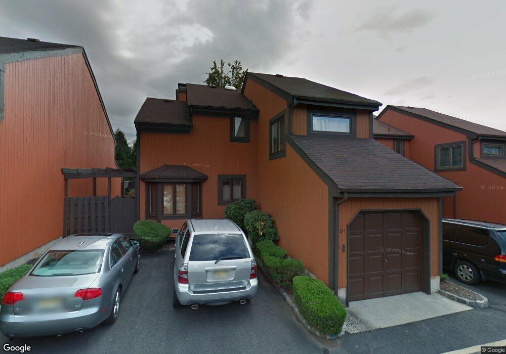
154 Riverbend Dr North Brunswick, NJ 08902
Estimated Value: $506,974 - $537,000
--
Bed
--
Bath
1,576
Sq Ft
$330/Sq Ft
Est. Value
About This Home
This home is located at 154 Riverbend Dr, North Brunswick, NJ 08902 and is currently estimated at $519,494, approximately $329 per square foot. 154 Riverbend Dr is a home located in Middlesex County with nearby schools including John Adams Elementary School, Linwood Middle School, and North Brunswick Twp High School.
Ownership History
Date
Name
Owned For
Owner Type
Purchase Details
Closed on
Jul 10, 2013
Sold by
Murphy Bhasker T and Thodla Bhasker
Bought by
Thodla Bhaskar and Thodla Shobha B
Current Estimated Value
Purchase Details
Closed on
Dec 5, 2001
Sold by
Howell Laurence
Bought by
Murthy Bhaskart
Home Financials for this Owner
Home Financials are based on the most recent Mortgage that was taken out on this home.
Original Mortgage
$168,500
Outstanding Balance
$66,575
Interest Rate
6.72%
Estimated Equity
$452,919
Purchase Details
Closed on
Jun 27, 1997
Sold by
Basile Elizabeth
Bought by
Howell Laurence and Howell Rosemary
Home Financials for this Owner
Home Financials are based on the most recent Mortgage that was taken out on this home.
Original Mortgage
$140,000
Interest Rate
7.86%
Create a Home Valuation Report for This Property
The Home Valuation Report is an in-depth analysis detailing your home's value as well as a comparison with similar homes in the area
Home Values in the Area
Average Home Value in this Area
Purchase History
| Date | Buyer | Sale Price | Title Company |
|---|---|---|---|
| Thodla Bhaskar | -- | None Available | |
| Murthy Bhaskart | $215,000 | -- | |
| Howell Laurence | $155,000 | -- |
Source: Public Records
Mortgage History
| Date | Status | Borrower | Loan Amount |
|---|---|---|---|
| Open | Murthy Bhaskart | $168,500 | |
| Previous Owner | Howell Laurence | $140,000 |
Source: Public Records
Tax History Compared to Growth
Tax History
| Year | Tax Paid | Tax Assessment Tax Assessment Total Assessment is a certain percentage of the fair market value that is determined by local assessors to be the total taxable value of land and additions on the property. | Land | Improvement |
|---|---|---|---|---|
| 2025 | $9,859 | $155,600 | $38,200 | $117,400 |
| 2024 | $9,681 | $155,600 | $38,200 | $117,400 |
| 2023 | $9,681 | $155,600 | $38,200 | $117,400 |
| 2022 | $9,352 | $155,600 | $38,200 | $117,400 |
| 2021 | $6,813 | $155,600 | $38,200 | $117,400 |
| 2020 | $9,003 | $155,600 | $38,200 | $117,400 |
| 2019 | $8,819 | $155,600 | $38,200 | $117,400 |
| 2018 | $8,639 | $155,600 | $38,200 | $117,400 |
| 2017 | $8,486 | $155,600 | $38,200 | $117,400 |
| 2016 | $8,309 | $155,600 | $38,200 | $117,400 |
| 2015 | $8,167 | $155,600 | $38,200 | $117,400 |
| 2014 | $8,076 | $155,600 | $38,200 | $117,400 |
Source: Public Records
Map
Nearby Homes
- 1150 Schmidt Ln
- 1027 Schmidt Ln
- 1008 Schmidt Ln
- 1074 Schmidt Ln
- 66 Riverbend Dr
- 3 Quince Place
- 174 Nathan Dr
- 18 Sheffield Ct
- 280 Willowbrook Dr
- 310 Willowbrook Dr
- 320 Willowbrook Dr
- 62 Goodwin Dr
- 12 Gallop Ln
- 1 Michael Ct
- 38 Brighton Way Unit H2
- 448 Northam Dr Unit A3
- 464 Northam Dr
- 34 Princess Dr
- 480 Witney Ct
- 1632 Hudson Ave
- 152 Riverbend Dr
- 156 Riverbend Dr
- 150 Riverbend Dr
- 140 Riverbend Dr
- 148 Riverbend Dr
- 138 Riverbend Dr
- 142 Riverbend Dr
- 146 Riverbend Dr
- 144 Riverbend Dr
- 1126 Schmidt Ln
- 134 Riverbend Dr
- 1127 Schmidt Ln
- 132 Riverbend Dr
- 136 Riverbend Dr
- 130 Riverbend Dr
- 1125 Schmidt Ln
- 1128 Schmidt Ln
- 1124 Schmidt Ln
- 1124 Schmidt Ln Unit 24
- 128 Riverbend Dr