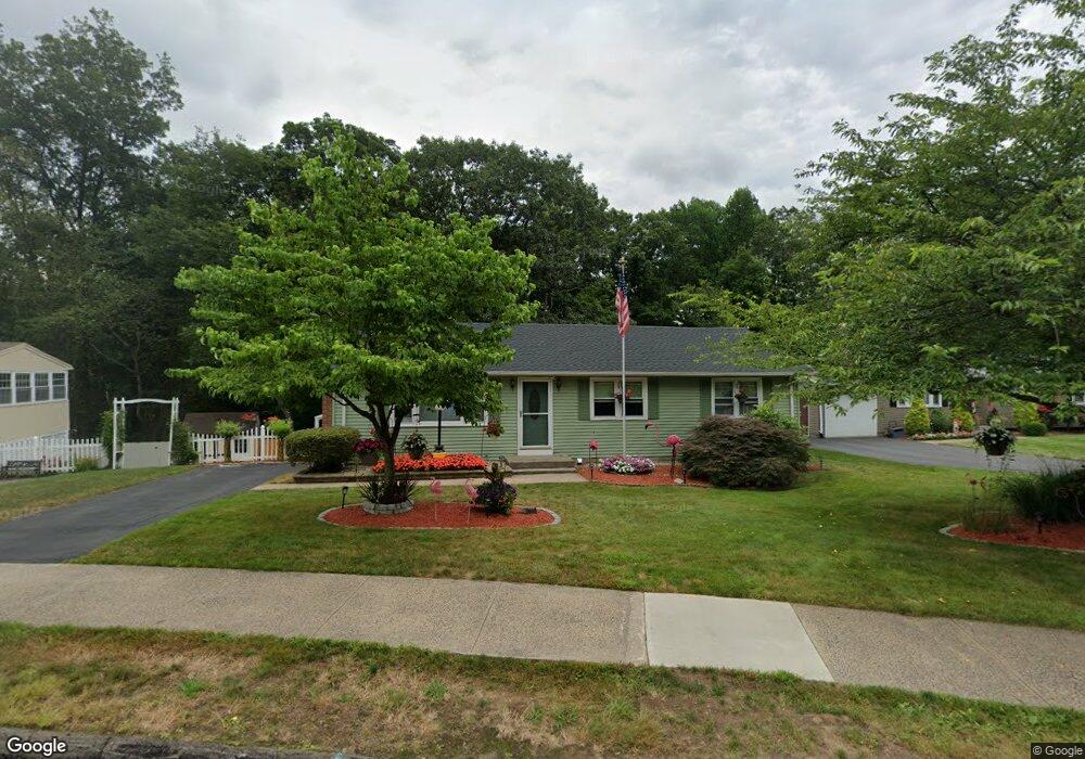
154 Stevenson Rd Meriden, CT 06451
Estimated Value: $372,000 - $400,000
3
Beds
3
Baths
1,104
Sq Ft
$348/Sq Ft
Est. Value
About This Home
This home is located at 154 Stevenson Rd, Meriden, CT 06451 and is currently estimated at $383,695, approximately $347 per square foot. 154 Stevenson Rd is a home located in New Haven County with nearby schools including Hanover School, Lincoln Middle School, and Orville H. Platt High School.
Ownership History
Date
Name
Owned For
Owner Type
Purchase Details
Closed on
Jul 29, 1993
Sold by
Lynch Mark J and Zawryt Margaret G
Bought by
Gilluly Brian and Gilluly Michelle
Current Estimated Value
Create a Home Valuation Report for This Property
The Home Valuation Report is an in-depth analysis detailing your home's value as well as a comparison with similar homes in the area
Home Values in the Area
Average Home Value in this Area
Purchase History
| Date | Buyer | Sale Price | Title Company |
|---|---|---|---|
| Gilluly Brian | $119,900 | -- |
Source: Public Records
Mortgage History
| Date | Status | Borrower | Loan Amount |
|---|---|---|---|
| Open | Gilluly Brian | $49,012 | |
| Open | Gilluly Brian | $185,000 | |
| Closed | Gilluly Brian | $58,500 | |
| Closed | Gilluly Brian | $32,500 |
Source: Public Records
Tax History
| Year | Tax Paid | Tax Assessment Tax Assessment Total Assessment is a certain percentage of the fair market value that is determined by local assessors to be the total taxable value of land and additions on the property. | Land | Improvement |
|---|---|---|---|---|
| 2025 | $6,914 | $172,410 | $68,950 | $103,460 |
| 2024 | $6,260 | $172,410 | $68,950 | $103,460 |
| 2023 | $5,998 | $172,410 | $68,950 | $103,460 |
| 2022 | $5,688 | $172,410 | $68,950 | $103,460 |
| 2021 | $5,094 | $124,670 | $54,530 | $70,140 |
| 2020 | $5,094 | $124,670 | $54,530 | $70,140 |
| 2019 | $5,094 | $124,670 | $54,530 | $70,140 |
| 2018 | $5,116 | $124,670 | $54,530 | $70,140 |
| 2017 | $4,977 | $124,670 | $54,530 | $70,140 |
| 2016 | $4,723 | $128,940 | $46,620 | $82,320 |
| 2015 | $4,723 | $128,940 | $46,620 | $82,320 |
| 2014 | $4,608 | $128,940 | $46,620 | $82,320 |
Source: Public Records
Map
Nearby Homes
- 133 Stevenson Rd
- 274 Riverside Dr
- 105 Riverside Dr
- 25 Andrews St
- 97 Race Brook Rd
- 63 Spice Hill Dr
- 68 Lynn Dr
- 100 Spice Hill Dr
- 661 Allen Ave
- 199 Glen Hills Rd
- 174 Westfort Dr
- 194 Debbie Dr
- 295 & 305 (Lot 103 & Oregon St
- 115 Cynrose Place
- 173 Cynrose Place
- 201 New Cheshire Rd
- 23 N Pond Rd
- 707 Hanover Rd
- 16 Greenway Place
- 50 Fairfax Ave
- 150 Stevenson Rd
- 162 Stevenson Rd
- 146 Stevenson Rd
- 170 Stevenson Rd
- 171 Stevenson Rd
- 163 Stevenson Rd
- 142 Stevenson Rd
- 169 Stevenson Rd
- 119 Stevenson Rd
- 136 Stevenson Rd
- 92 Pettit Dr
- 96 Pettit Dr
- 86 Pettit Dr
- 132 Stevenson Rd
- 111 Stevenson Rd
- 100 Pettit Dr
- 128 Stevenson Rd
- 0 River Rd
- 421 River Rd
- 82 Pettit Dr
Your Personal Tour Guide
Ask me questions while you tour the home.