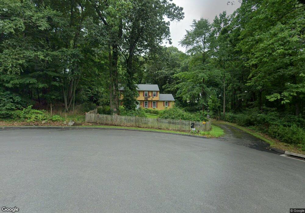
154 Thurton Dr New Canaan, CT 06840
Estimated Value: $1,765,819 - $2,222,000
4
Beds
3
Baths
2,430
Sq Ft
$799/Sq Ft
Est. Value
About This Home
This home is located at 154 Thurton Dr, New Canaan, CT 06840 and is currently estimated at $1,940,955, approximately $798 per square foot. 154 Thurton Dr is a home located in Fairfield County with nearby schools including West Elementary School, Saxe Middle School, and New Canaan High School.
Ownership History
Date
Name
Owned For
Owner Type
Purchase Details
Closed on
Aug 7, 1986
Bought by
Uva Anthony J and Uva Frances C
Current Estimated Value
Create a Home Valuation Report for This Property
The Home Valuation Report is an in-depth analysis detailing your home's value as well as a comparison with similar homes in the area
Home Values in the Area
Average Home Value in this Area
Purchase History
| Date | Buyer | Sale Price | Title Company |
|---|---|---|---|
| Uva Anthony J | $442,300 | -- |
Source: Public Records
Mortgage History
| Date | Status | Borrower | Loan Amount |
|---|---|---|---|
| Closed | Uva Anthony J | $121,000 | |
| Closed | Uva Anthony J | $45,000 |
Source: Public Records
Tax History Compared to Growth
Tax History
| Year | Tax Paid | Tax Assessment Tax Assessment Total Assessment is a certain percentage of the fair market value that is determined by local assessors to be the total taxable value of land and additions on the property. | Land | Improvement |
|---|---|---|---|---|
| 2025 | $15,591 | $934,150 | $621,600 | $312,550 |
| 2024 | $15,077 | $934,150 | $621,600 | $312,550 |
| 2023 | $15,375 | $811,790 | $673,890 | $137,900 |
| 2022 | $14,913 | $811,790 | $673,890 | $137,900 |
| 2021 | $14,742 | $811,790 | $673,890 | $137,900 |
| 2020 | $14,742 | $811,790 | $673,890 | $137,900 |
| 2019 | $14,807 | $811,790 | $673,890 | $137,900 |
| 2018 | $12,682 | $747,740 | $623,980 | $123,760 |
| 2017 | $12,465 | $747,740 | $623,980 | $123,760 |
| 2016 | $12,196 | $747,740 | $623,980 | $123,760 |
| 2015 | $12,383 | $747,740 | $623,980 | $123,760 |
| 2014 | $11,620 | $747,740 | $623,980 | $123,760 |
Source: Public Records
Map
Nearby Homes
- 470 Frogtown Rd Unit Lot 1
- 474 Ponus Ridge
- 357 Jelliff Mill Rd
- 202 Weed St
- 113 Skyview Ln
- 100 Spring Water Ln
- 139 Jelliff Mill Rd
- 39 Running Brook Ln
- 317 Park St
- 25 Gower Rd
- 197 Park St Unit 13
- 1552 Hope St
- 354 South Ave
- 185 Interlaken Rd
- 119 Wedgemere Rd
- 865 Hollow Tree Ridge Rd
- 50 Harrison Ave
- 105 N Stamford Rd
- 15 Burtis Ave Unit Townhome D
- 15 Burtis Ave Unit West Penthouse B
- 69 Welles Ln
- 151 Thurton Dr
- 155 Thurton Dr
- 49 Welles Ln
- 136 Thurton Dr
- 156 Thurton Dr
- 57 Welles Ln
- 131 Thurton Dr
- 210 Indian Waters Dr
- 139 Thurton Dr
- 552 Frogtown Rd
- 141 Thurton Dr
- 512 Frogtown Rd
- 204 Indian Waters Dr
- 113 Thurton Dr
- 510 Frogtown Rd
- 550 Frogtown Rd
- 54 Welles Ln
- 68 Welles Ln
- 98 Thurton Dr