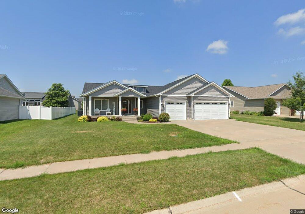
1540 Fox Ridge Rd Eldridge, IA 52748
Estimated Value: $508,000 - $567,000
4
Beds
4
Baths
2,021
Sq Ft
$268/Sq Ft
Est. Value
About This Home
This home is located at 1540 Fox Ridge Rd, Eldridge, IA 52748 and is currently estimated at $542,453, approximately $268 per square foot. 1540 Fox Ridge Rd is a home located in Scott County with nearby schools including Alan Shepard Elementary School, North Scott Junior High School, and North Scott Senior High School.
Ownership History
Date
Name
Owned For
Owner Type
Purchase Details
Closed on
Jun 3, 2015
Sold by
Brimmer Mark J and Brimmer Abgela D
Bought by
Oetzmann Builders Llc
Current Estimated Value
Purchase Details
Closed on
Mar 2, 2010
Sold by
Midwestone Bank
Bought by
Brimmer Mark J
Create a Home Valuation Report for This Property
The Home Valuation Report is an in-depth analysis detailing your home's value as well as a comparison with similar homes in the area
Home Values in the Area
Average Home Value in this Area
Purchase History
| Date | Buyer | Sale Price | Title Company |
|---|---|---|---|
| Oetzmann Builders Llc | $62,500 | None Available | |
| Brimmer Mark J | $84,000 | None Available |
Source: Public Records
Tax History
| Year | Tax Paid | Tax Assessment Tax Assessment Total Assessment is a certain percentage of the fair market value that is determined by local assessors to be the total taxable value of land and additions on the property. | Land | Improvement |
|---|---|---|---|---|
| 2025 | $5,962 | $494,400 | $100,800 | $393,600 |
| 2024 | $5,808 | $475,300 | $100,800 | $374,500 |
| 2023 | $6,060 | $475,300 | $100,800 | $374,500 |
| 2022 | $4,946 | $425,680 | $53,510 | $372,170 |
| 2021 | $4,946 | $359,870 | $53,510 | $306,360 |
| 2020 | $5,024 | $357,640 | $53,510 | $304,130 |
| 2019 | $5,114 | $348,660 | $53,510 | $295,150 |
| 2018 | $5,220 | $348,660 | $53,510 | $295,150 |
| 2017 | $1,939 | $348,660 | $53,510 | $295,150 |
| 2016 | $702 | $45,480 | $0 | $0 |
| 2015 | $702 | $5,800 | $0 | $0 |
| 2014 | $92 | $5,800 | $0 | $0 |
| 2013 | $90 | $0 | $0 | $0 |
| 2012 | -- | $5,800 | $5,800 | $0 |
Source: Public Records
Map
Nearby Homes
- 790 Muirfield Cir
- 1207 Colonial Ct
- 1218 S 2nd St
- 125 W Pinehurst Dr
- 1821 Redbud Cir
- 1867 Redbud Cir Unit 103
- 1832 Redbud Cir
- 1867 Redbud Cir Unit 102
- 1867 Redbud Cir Unit 101
- 1875 Redbud Cir Unit 102
- 1875 Redbud Cir Unit 103
- 1704 Redbud Cir Unit 101
- 1704 Redbud Cir Unit 103
- 1704 Redbud Cir Unit 102
- 1719 S 5th St
- 1719 5th St
- 1831 S 5th St
- 101 W Sheridan Dr
- 318 W Oak St
- 407 W Oak St
- 1510 Fox Ridge Rd
- 1570 Fox Ridge Rd
- 700 St Andrews Cir
- 609 St Andrews Cir
- 704 St Andrews Cir
- 601 St Andrews Cir
- 1600 Fox Ridge Rd
- 796 Rustic View Ct
- 605 St Andrews Cir
- 708 St Andrews Cir
- 850 Fox Ridge Rd
- 1471 Fox Ridge Rd
- 791 St Andrews
- 790 St Andrews
- 701 St Andrews Cir
- 800 Rustic View Ct
- 1451 Fox Ridge Rd
- 705 St Andrews Cir
- 1660 Fox Ridge Rd
- 725 St Andrews Cir
Your Personal Tour Guide
Ask me questions while you tour the home.