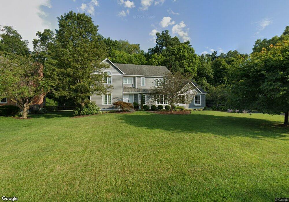
1542 Georgetown Rd Loveland, OH 45140
Outer Loveland NeighborhoodEstimated Value: $504,208 - $565,000
4
Beds
3
Baths
2,484
Sq Ft
$216/Sq Ft
Est. Value
About This Home
This home is located at 1542 Georgetown Rd, Loveland, OH 45140 and is currently estimated at $535,552, approximately $215 per square foot. 1542 Georgetown Rd is a home located in Clermont County with nearby schools including Milford Senior High School, Milford Christian Academy, and St. Andrew - St. Elizabeth Ann Seton School.
Ownership History
Date
Name
Owned For
Owner Type
Purchase Details
Closed on
Jun 23, 2010
Sold by
Douglass Edward M and Douglass Nancy L
Bought by
Williams Aaron G and Williams Courtney A
Current Estimated Value
Home Financials for this Owner
Home Financials are based on the most recent Mortgage that was taken out on this home.
Original Mortgage
$279,239
Outstanding Balance
$191,944
Interest Rate
5.5%
Mortgage Type
FHA
Estimated Equity
$343,608
Purchase Details
Closed on
Oct 1, 1990
Create a Home Valuation Report for This Property
The Home Valuation Report is an in-depth analysis detailing your home's value as well as a comparison with similar homes in the area
Home Values in the Area
Average Home Value in this Area
Purchase History
| Date | Buyer | Sale Price | Title Company |
|---|---|---|---|
| Williams Aaron G | $283,000 | Prominent Title | |
| -- | $173,500 | -- |
Source: Public Records
Mortgage History
| Date | Status | Borrower | Loan Amount |
|---|---|---|---|
| Open | Williams Aaron G | $279,239 |
Source: Public Records
Tax History Compared to Growth
Tax History
| Year | Tax Paid | Tax Assessment Tax Assessment Total Assessment is a certain percentage of the fair market value that is determined by local assessors to be the total taxable value of land and additions on the property. | Land | Improvement |
|---|---|---|---|---|
| 2024 | $6,060 | $130,380 | $27,580 | $102,800 |
| 2023 | $6,122 | $130,380 | $27,580 | $102,800 |
| 2022 | $5,215 | $84,350 | $17,850 | $66,500 |
| 2021 | $5,217 | $84,350 | $17,850 | $66,500 |
| 2020 | $4,993 | $84,350 | $17,850 | $66,500 |
| 2019 | $5,767 | $92,650 | $17,640 | $75,010 |
| 2018 | $5,769 | $92,650 | $17,640 | $75,010 |
| 2017 | $5,930 | $92,650 | $17,640 | $75,010 |
| 2016 | $6,038 | $88,240 | $16,800 | $71,440 |
| 2015 | $5,532 | $88,240 | $16,800 | $71,440 |
| 2014 | $5,532 | $88,240 | $16,800 | $71,440 |
| 2013 | $5,041 | $77,980 | $17,500 | $60,480 |
Source: Public Records
Map
Nearby Homes
- 6379 Derbyshire Ln
- 1513 Charleston Ln
- 5937 Firm Stance Dr
- 1146 Clover Field Dr
- 1140 Weber Rd
- 1113 Clover Field Dr
- 6149 Century Farm Dr
- 2013 Weber Rd
- 962 Paul Vista Dr
- 1331 Harbor Cove
- 1809 Wheatfield Way
- 1803 Wheatfield Way
- 955 Paul Vista Dr
- 6469 Brittany Ln
- 802 Andrea Dr
- 899 Murle Ln
- 709 Middleton Way
- 6211 Spires Dr
- 5893 Meadow Lark Ct
- 6557 Oasis Dr
- 1544 Georgetown Rd
- 1540 Georgetown Rd
- 6367 Derbyshire Ln
- 1546 Georgetown Rd
- 1538 Georgetown Rd
- 6365 Derbyshire Ln
- 1545 Georgetown Rd
- 6369 Derbyshire Ln
- 6363 Derbyshire Ln
- 1548 Georgetown Rd
- 1536 Georgetown Rd
- 1539 Georgetown Rd
- 1549 Georgetown Rd
- 6361 Derbyshire Ln
- 6371 Derbyshire Ln
- 6373 Derbyshire Ln
- 6333 Macon Ct
- 1550 Georgetown Rd
- 1534 Georgetown Rd
- 6336 Belmont Rd