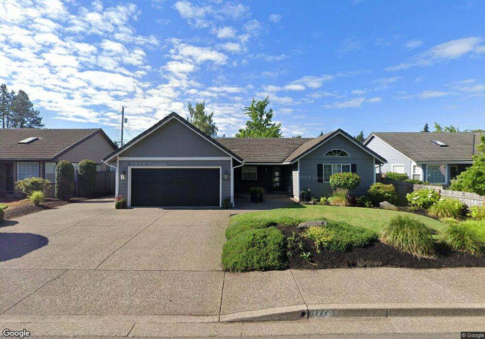
1542 Martingale St Eugene, OR 97401
Harlow NeighborhoodEstimated Value: $548,000 - $627,000
3
Beds
2
Baths
1,688
Sq Ft
$348/Sq Ft
Est. Value
About This Home
This home is located at 1542 Martingale St, Eugene, OR 97401 and is currently estimated at $587,729, approximately $348 per square foot. 1542 Martingale St is a home located in Lane County with nearby schools including Holt Elementary School, Monroe Middle School, and Sheldon High School.
Ownership History
Date
Name
Owned For
Owner Type
Purchase Details
Closed on
Apr 7, 2015
Sold by
Carter Wanda K and Carter Wanda
Bought by
Carter Wanda K
Current Estimated Value
Home Financials for this Owner
Home Financials are based on the most recent Mortgage that was taken out on this home.
Original Mortgage
$271,000
Interest Rate
3.76%
Mortgage Type
New Conventional
Create a Home Valuation Report for This Property
The Home Valuation Report is an in-depth analysis detailing your home's value as well as a comparison with similar homes in the area
Home Values in the Area
Average Home Value in this Area
Purchase History
| Date | Buyer | Sale Price | Title Company |
|---|---|---|---|
| Carter Wanda K | -- | Fnt |
Source: Public Records
Mortgage History
| Date | Status | Borrower | Loan Amount |
|---|---|---|---|
| Closed | Carter Wanda K | $271,000 |
Source: Public Records
Tax History
| Year | Tax Paid | Tax Assessment Tax Assessment Total Assessment is a certain percentage of the fair market value that is determined by local assessors to be the total taxable value of land and additions on the property. | Land | Improvement |
|---|---|---|---|---|
| 2025 | $6,466 | $331,845 | -- | -- |
| 2024 | $6,385 | $322,180 | -- | -- |
| 2023 | $6,385 | $312,797 | $0 | $0 |
| 2022 | $5,982 | $303,687 | $0 | $0 |
| 2021 | $5,618 | $294,842 | $0 | $0 |
| 2020 | $5,599 | $286,255 | $0 | $0 |
| 2019 | $5,361 | $277,918 | $0 | $0 |
| 2018 | $5,003 | $261,965 | $0 | $0 |
| 2017 | $4,736 | $261,965 | $0 | $0 |
| 2016 | $4,503 | $254,335 | $0 | $0 |
| 2015 | $4,348 | $246,927 | $0 | $0 |
| 2014 | $4,254 | $239,735 | $0 | $0 |
Source: Public Records
Map
Nearby Homes
- 0 Sprig Ln Unit Lot 3
- 0 Sprig Ln Unit Lot 3 766109892
- 2956 Willakenzie Rd
- 1798 Duke Ct
- 1625 Victorian Way
- 1564 Regency Dr
- 1630 Ridgley Blvd
- 3387 Winchester Way
- 3424 Sussex St
- 2580 Elysium Ave
- 1271 Arcadia Dr
- 1050 President St
- 2577 Elysium Ave
- 2495 Jeppesen Acres Rd
- 1090 Corydon St
- 825 Waverly St
- 950 Coburg Rd
- 3700 Babcock Ln Unit 87
- 2872 Suffolk Ct
- 2700 Harlow Rd Unit 6
- 1520 Martingale St
- 1564 Martingale St
- 1523 Bar M Dr
- 1537 Bar M Dr
- 1510 Martingale St
- 1509 Bar M Dr
- 1586 Martingale St
- 1541 Bar M Dr
- 1575 Martingale St
- 1506 Martingale St
- 1495 Bar M Dr
- 1598 Martingale St
- 1599 Martingale St
- 1555 Bar M Dr
- 1572 Thornberry St
- 3016 Willakenzie Rd
- 1500 Martingale St
- 1483 Bar M Dr
- 1563 Bar M Dr
- 3010 Willakenzie Rd
Your Personal Tour Guide
Ask me questions while you tour the home.