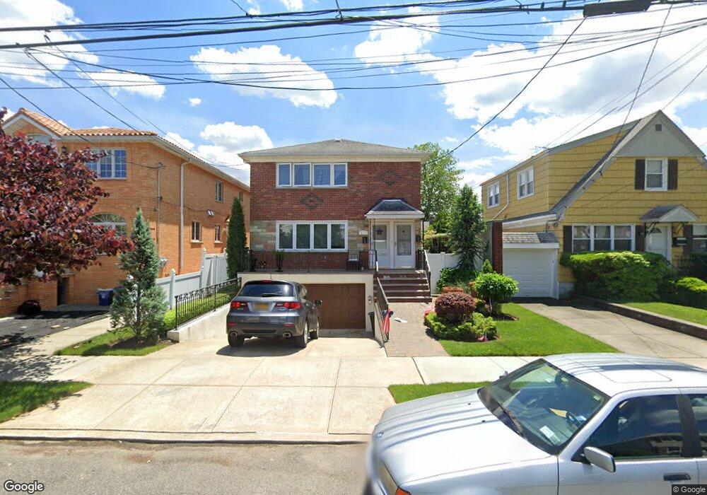
15422 20th Rd Whitestone, NY 11357
Whitestone NeighborhoodEstimated Value: $1,300,000 - $1,663,000
Studio
--
Bath
2,400
Sq Ft
$618/Sq Ft
Est. Value
About This Home
This home is located at 15422 20th Rd, Whitestone, NY 11357 and is currently estimated at $1,484,084, approximately $618 per square foot. 15422 20th Rd is a home located in Queens County with nearby schools including P.S. 79 - Francis Lewis, J.H.S. 194 William Carr, and Bayside High School.
Ownership History
Date
Name
Owned For
Owner Type
Purchase Details
Closed on
Dec 31, 1998
Sold by
Palios Irene
Bought by
Stathis Harriet and Palios Louis
Current Estimated Value
Purchase Details
Closed on
Nov 4, 1998
Sold by
The Palios Family Trust and Palios Emanuel
Bought by
Palios Irene
Purchase Details
Closed on
Jun 26, 1996
Sold by
Palios Emanuel and Palios Irene
Bought by
Palios Emanuel and Palios Irene
Create a Home Valuation Report for This Property
The Home Valuation Report is an in-depth analysis detailing your home's value as well as a comparison with similar homes in the area
Home Values in the Area
Average Home Value in this Area
Purchase History
| Date | Buyer | Sale Price | Title Company |
|---|---|---|---|
| Stathis Harriet | -- | Fidelity National Title Ins | |
| Stathis Harriet | -- | Fidelity National Title Ins | |
| Palios Irene | -- | Fidelity National Title Ins | |
| Palios Irene | -- | Fidelity National Title Ins | |
| Palios Emanuel | -- | First American Title Ins Co | |
| Palios Emanuel | -- | First American Title Ins Co |
Source: Public Records
Tax History
| Year | Tax Paid | Tax Assessment Tax Assessment Total Assessment is a certain percentage of the fair market value that is determined by local assessors to be the total taxable value of land and additions on the property. | Land | Improvement |
|---|---|---|---|---|
| 2025 | $10,724 | $56,598 | $6,682 | $49,916 |
| 2024 | $10,724 | $53,395 | $6,969 | $46,426 |
| 2023 | $10,844 | $53,395 | $6,550 | $46,845 |
| 2022 | $10,579 | $88,740 | $11,880 | $76,860 |
| 2021 | $10,521 | $79,080 | $11,880 | $67,200 |
| 2020 | $9,983 | $75,120 | $11,880 | $63,240 |
| 2019 | $9,308 | $72,660 | $11,880 | $60,780 |
| 2018 | $8,773 | $44,496 | $6,329 | $38,167 |
| 2017 | $8,703 | $44,161 | $7,069 | $37,092 |
| 2016 | $8,019 | $44,161 | $7,069 | $37,092 |
| 2015 | $5,089 | $39,304 | $11,653 | $27,651 |
| 2014 | $5,089 | $37,080 | $13,200 | $23,880 |
Source: Public Records
Map
Nearby Homes
- 154-09 21st Ave
- 154-27 20th Rd
- 154-36 20th Rd
- 15458 20th Rd
- 15411 Willets Point Blvd
- 151 E 20th St Unit 2-C
- 154-46 22nd Ave
- 151-35 20th Rd
- 151-25 21st Ave
- 151-26 20th Ave
- 154-07 24th Rd
- 17-02 Clintonville St
- 1665 156th St
- 17 Murray St Unit 3
- 17 Murray St Unit 4
- 157-45 17th Rd Unit 1
- 151-28 24th Rd
- 15121 17th Ave
- 150-38 24th Ave
- 15750 17th Ave Unit 540
- 15416 20th Rd
- 15426 20th Rd
- 15410 20th Rd
- 154-30 20th Rd Unit 2nd Fl
- 15421 21st Ave
- 15419 21st Ave
- 154-32 20th Rd Unit 2nd Fl
- 15425 21st Ave
- 15415 21st Ave
- 15434 20th Rd
- 15429 21st Ave
- 154-36 20th Rd Unit 2nd fl
- 154-36 20th Rd Unit 1
- 15436 20th Rd
- 154-25 20th Rd
- 15433 21st Ave
- 15421 20th Rd
- 15425 20th Rd
- 2037 154th St
- 2031 154th St
Your Personal Tour Guide
Ask me questions while you tour the home.