


1543 Highway 11 W Chesnee, SC 29323
Estimated payment $5,451/month
Highlights
- Primary Bedroom Suite
- Craftsman Architecture
- Outdoor Fireplace
- Chesnee Elementary School Rated A-
- Vaulted Ceiling
- Wood Flooring
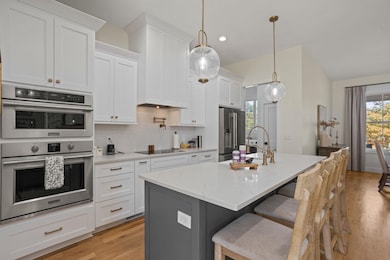
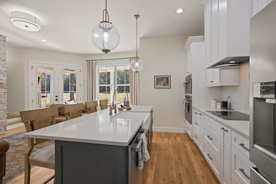
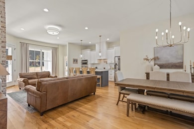
About This Home
Charming 2-Year-Old Craftsman Home with Guest Cottage on 9.43 Acres! Experience the perfect blend of modern comfort and country charm in this stunning Craftsman-style home. Featuring vaulted ceilings, gleaming hardwood floors, and an open, airy floor plan, this home is designed for relaxed living and easy entertaining. The gourmet kitchen is a showstopper—complete with a large island, quartz countertops, pot filler, custom cabinetry, upgraded appliances, and two pantries for ample storage. The adjoining dining area opens seamlessly to the great room, creating the ideal space for family gatherings and entertaining friends. Step outside to the covered rear porch with a wood-burning fireplace—perfect for cozy fireside evenings. The owner’s suite offers a private retreat with porch access, hardwood floors, trey ceiling, a luxurious tile shower with dual showerheads, marble floors and countertops, and a custom walk-in closet. Two additional bedrooms, each with hardwood flooring, share a stylish hall bath. Upstairs, you’ll find a spacious flex room with a half bath—ideal for a playroom, gym, or media space. A second flex room offers even more possibilities as a guest suite or potential fourth bedroom with the easy addition of a closet. Walk-out attic storage adds convenience. The guest cottage is equally impressive, featuring a combined den and kitchenette, large bedroom with generous closet space, two full baths, and a mudroom/laundry area—all finished with the same quality craftsmanship as the main home. Enjoy peaceful mornings on the rocking-chair front porches of both homes. Outside, a detached carport and workshop, gravel patio with firepit, and serene landscape create a relaxing country vibe. The cottage has separate utilities (power, water, and septic) and its own driveway. The pasture area offers multiple fenced sections, a barn, and access from two roads. An old septic tank and water hookup from a previous home provide potential for an additional homesite. This exceptional property truly has it all—modern luxury, versatile living spaces, and the tranquility of country life.
Home Details
Home Type
- Single Family
Est. Annual Taxes
- $2,791
Year Built
- Built in 2023
Lot Details
- 9.43 Acre Lot
- Level Lot
Parking
- 4 Car Garage
- Workshop in Garage
- Side Facing Garage
- Driveway
Home Design
- Craftsman Architecture
- Traditional Architecture
- Architectural Shingle Roof
- HardiePlank Siding
Interior Spaces
- 1,999 Sq Ft Home
- 2-Story Property
- Vaulted Ceiling
- 2 Fireplaces
- Gas Log Fireplace
- Insulated Windows
- Tilt-In Windows
- Window Treatments
- Mud Room
- Great Room
- Dining Room
- Bonus Room
- Crawl Space
- Fire and Smoke Detector
Kitchen
- Dishwasher
- Utility Sink
- Pot Filler
Flooring
- Wood
- Ceramic Tile
Bedrooms and Bathrooms
- 3 Bedrooms
- Primary Bedroom Suite
- Split Bedroom Floorplan
Laundry
- Laundry Room
- Laundry on main level
- Washer and Electric Dryer Hookup
Outdoor Features
- Outdoor Fireplace
- Porch
Schools
- Chesnee Elementary School
- Chesnee Middle School
- Chesnee High School
Farming
- Horse or Livestock Barn
- Pasture
- Fenced For Horses
Utilities
- Heat Pump System
- Underground Utilities
- Septic Tank
- Cable TV Available
Community Details
- No Home Owners Association
Map
Home Values in the Area
Average Home Value in this Area
Tax History
| Year | Tax Paid | Tax Assessment Tax Assessment Total Assessment is a certain percentage of the fair market value that is determined by local assessors to be the total taxable value of land and additions on the property. | Land | Improvement |
|---|---|---|---|---|
| 2025 | $2,781 | $17,521 | $3,693 | $13,828 |
| 2024 | $2,781 | $17,521 | $3,693 | $13,828 |
| 2023 | $2,781 | $4,319 | $4,319 | $0 |
| 2022 | $782 | $3,392 | $2,324 | $1,068 |
| 2021 | $1,112 | $5,314 | $2,462 | $2,852 |
| 2020 | $1,989 | $6,484 | $2,462 | $4,022 |
| 2019 | $1,903 | $1,630 | $1,118 | $512 |
| 2018 | $469 | $1,630 | $1,118 | $512 |
| 2017 | $1,178 | $3,210 | $2,442 | $768 |
| 2016 | $483 | $1,215 | $447 | $768 |
| 2015 | $1,418 | $6,090 | $3,744 | $2,346 |
| 2014 | $2,173 | $6,090 | $3,744 | $2,346 |
Property History
| Date | Event | Price | List to Sale | Price per Sq Ft |
|---|---|---|---|---|
| 11/07/2025 11/07/25 | For Sale | $995,000 | -- | $498 / Sq Ft |
Purchase History
| Date | Type | Sale Price | Title Company |
|---|---|---|---|
| Interfamily Deed Transfer | -- | None Available | |
| Deed | $90,000 | None Available | |
| Deed | -- | Attorney | |
| Deed | -- | Attorney | |
| Deed Of Distribution | -- | -- |
Source: Multiple Listing Service of Spartanburg
MLS Number: SPN330648
APN: 2-13-00-021.00
Disclaimer: Certain information contained herein is derived from information provided by parties other than Homes.com. All information provided is deemed reliable, but is not guaranteed to be accurate and should be independently verified.
![]() IDX information is provided exclusively for personal, non-commercial use, and may not be used for any purpose other than to identify prospective properties consumers may be interested in purchasing.
IDX information is provided exclusively for personal, non-commercial use, and may not be used for any purpose other than to identify prospective properties consumers may be interested in purchasing.
Information is deemed reliable but not guaranteed.
- 140 Manor House Ln
- 216 Sweetgrass Dr
- 569 State Road S-42-1879
- 565 State Road S-42-1879
- 561 State Road S-42-1879
- 545 State Road S-42-1879
- 537 State Road S-42-1879
- 523 State Road S-42-1879
- 268 Margate Cir
- 0 State Road S-42-1879
- 351 Smith Wall Rd
- 202 Arrowood Branch Rd
- 190 Clement Rd
- 170 State Road S-42-2318
- 0 Cantrell Dr
- 101 Foster Cir
- 550 Harris Rd
- 301 Texas Ave
- 5039 Burke Meadows Run
- 5039 Burke Meadows Run Unit Homesite 9
- 404 Fairfield Rd
- 2044 Sandy Ford Rd Unit 2044 Sandy Ford Rd
- 346 Elevation Ct
- 514 Cornucopia Ln
- 3093 Whispering Willows Ct
- 1303 Peak View Dr
- 65 Thurgood Marshall Rd
- 305 Concert Way
- 151 Twin Creek Dr
- 235 Outlook Dr
- 1820 Bluejay Ln
- 6042 Willutuck Dr
- 1438 Cattleman Acrs Dr
- 931 Bryden Ln
- 901 Dornoch Dr
- 97 Mills Gap Rd
- 178 Big Island Rd
- 536 Bella Casa Run
- 382 Davis Rd
- 380 Davis Rd
