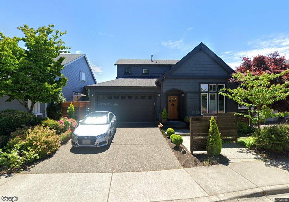
15446 NW Graf St Portland, OR 97229
Estimated Value: $700,679 - $711,000
3
Beds
7
Baths
2,211
Sq Ft
$319/Sq Ft
Est. Value
About This Home
This home is located at 15446 NW Graf St, Portland, OR 97229 and is currently estimated at $704,920, approximately $318 per square foot. 15446 NW Graf St is a home located in Washington County with nearby schools including Sato Elementary School, Stoller Middle School, and Westview High School.
Ownership History
Date
Name
Owned For
Owner Type
Purchase Details
Closed on
Jul 28, 2016
Sold by
Moskoff Berkey Sarah and Moskoff Sarah
Bought by
Bertsey John C
Current Estimated Value
Purchase Details
Closed on
Sep 26, 2006
Sold by
Allen Michael P
Bought by
Moskoff Sarah
Purchase Details
Closed on
Jun 12, 2001
Sold by
Renaissance Custom Homes Llc
Bought by
Allen Michael P and Moskoff Sarah M
Home Financials for this Owner
Home Financials are based on the most recent Mortgage that was taken out on this home.
Original Mortgage
$229,750
Interest Rate
7.14%
Create a Home Valuation Report for This Property
The Home Valuation Report is an in-depth analysis detailing your home's value as well as a comparison with similar homes in the area
Home Values in the Area
Average Home Value in this Area
Purchase History
| Date | Buyer | Sale Price | Title Company |
|---|---|---|---|
| Bertsey John C | -- | None Available | |
| Moskoff Sarah | $40,000 | None Available | |
| Allen Michael P | $287,222 | Oregon Title Insurance Co |
Source: Public Records
Mortgage History
| Date | Status | Borrower | Loan Amount |
|---|---|---|---|
| Previous Owner | Allen Michael P | $229,750 | |
| Closed | Allen Michael P | $28,550 |
Source: Public Records
Tax History Compared to Growth
Tax History
| Year | Tax Paid | Tax Assessment Tax Assessment Total Assessment is a certain percentage of the fair market value that is determined by local assessors to be the total taxable value of land and additions on the property. | Land | Improvement |
|---|---|---|---|---|
| 2025 | $6,526 | $404,220 | -- | -- |
| 2024 | $6,293 | $392,450 | -- | -- |
| 2023 | $6,293 | $381,020 | $0 | $0 |
| 2022 | $6,075 | $381,020 | $0 | $0 |
| 2021 | $5,847 | $359,160 | $0 | $0 |
| 2020 | $5,672 | $348,700 | $0 | $0 |
| 2019 | $5,489 | $338,550 | $0 | $0 |
| 2018 | $5,305 | $328,690 | $0 | $0 |
| 2017 | $5,114 | $319,120 | $0 | $0 |
| 2016 | $4,926 | $309,830 | $0 | $0 |
| 2015 | $4,734 | $300,810 | $0 | $0 |
| 2014 | $4,615 | $292,050 | $0 | $0 |
Source: Public Records
Map
Nearby Homes
- 15602 NW Graf St
- 15218 NW Twinflower Dr
- 15430 NW Delia St
- 15926 NW Rossetta St
- 15570 NW Snowbush Ln
- 15820 NW Linder St
- 15093 NW Vance Dr
- 15630 NW Brugger Rd
- 15997 NW Rossetta St
- 14868 NW Fawnlily Dr
- 14966 NW Vance Dr
- 15286 NW Moresby Ct
- 16222 NW Fescue Ct
- 14941 NW Wendy Ln
- 6621 NW Lolo Terrace
- 6163 NW Sickle Terrace
- 15157 NW Rosina Ln
- 16326 NW Rossetta St
- 15800 NW Sparks Ln
- 14919 NW Shackelford Rd
- 15480 NW Graf St
- 15412 NW Graf St
- 15514 NW Graf St
- 15536 NW Graf St
- 15509 NW Graf St
- 15392 NW Twoponds Dr
- 15427 NW Ryegrass St
- 15531 NW Graf St
- 15558 NW Graf St
- 15384 NW Twoponds Dr
- 15455 NW Ryegrass St
- 15389 NW Twoponds Dr
- 15420 NW Taennler Ct
- 15436 NW Taennler Ct
- 15553 NW Graf St
- 15376 NW Twoponds Dr
- 15556 NW Ryegrass St
- 15584 NW Graf St
- 15452 NW Taennler Ct
- 15381 NW Twoponds Dr