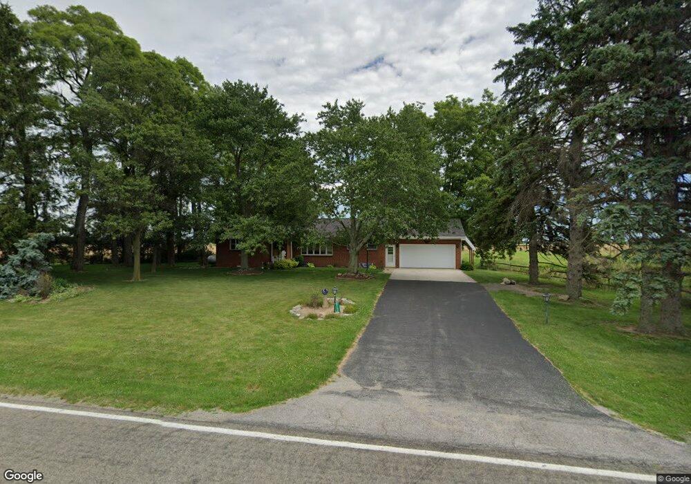
1549 Adams Ridge Rd Defiance, OH 43512
Estimated Value: $227,000 - $308,000
3
Beds
2
Baths
1,530
Sq Ft
$170/Sq Ft
Est. Value
About This Home
This home is located at 1549 Adams Ridge Rd, Defiance, OH 43512 and is currently estimated at $259,944, approximately $169 per square foot. 1549 Adams Ridge Rd is a home located in Defiance County with nearby schools including Tinora Elementary School, Noble Elementary School, and Tinora Middle School.
Ownership History
Date
Name
Owned For
Owner Type
Purchase Details
Closed on
Sep 15, 2023
Sold by
Schroeder Keith A and Schroeder Pamela S
Bought by
Keith A Schroeder Trust and Schroeder
Current Estimated Value
Purchase Details
Closed on
Feb 2, 2021
Sold by
Arps Robert W and Estate Of William Arps
Bought by
Schroeder Keith A and Schroeder Pamela S
Purchase Details
Closed on
Apr 12, 2016
Bought by
William Arps
Purchase Details
Closed on
Sep 9, 2013
Sold by
Arps William and Arps Lois A
Bought by
Arps William and Arps Lois A
Purchase Details
Closed on
Jan 1, 1992
Bought by
Arps William
Create a Home Valuation Report for This Property
The Home Valuation Report is an in-depth analysis detailing your home's value as well as a comparison with similar homes in the area
Home Values in the Area
Average Home Value in this Area
Purchase History
| Date | Buyer | Sale Price | Title Company |
|---|---|---|---|
| Keith A Schroeder Trust | -- | None Listed On Document | |
| Schroeder Keith A | $195,000 | None Available | |
| William Arps | -- | -- | |
| Arps William | -- | None Available | |
| Arps William | -- | -- |
Source: Public Records
Tax History Compared to Growth
Tax History
| Year | Tax Paid | Tax Assessment Tax Assessment Total Assessment is a certain percentage of the fair market value that is determined by local assessors to be the total taxable value of land and additions on the property. | Land | Improvement |
|---|---|---|---|---|
| 2024 | $2,267 | $65,350 | $3,890 | $61,460 |
| 2023 | $2,267 | $65,350 | $3,890 | $61,460 |
| 2022 | $2,158 | $52,570 | $3,630 | $48,940 |
| 2021 | $2,158 | $52,570 | $3,630 | $48,940 |
| 2020 | $1,800 | $52,570 | $3,630 | $48,940 |
| 2019 | $1,702 | $50,890 | $4,260 | $46,630 |
| 2018 | $1,751 | $50,890 | $4,260 | $46,630 |
| 2017 | $1,662 | $50,894 | $4,263 | $46,631 |
| 2016 | $1,590 | $51,156 | $4,263 | $46,893 |
| 2015 | $832 | $51,156 | $4,263 | $46,893 |
| 2014 | $832 | $51,208 | $4,315 | $46,893 |
| 2013 | $832 | $50,575 | $3,451 | $47,124 |
| 2012 | $832 | $50,575 | $3,451 | $47,124 |
Source: Public Records
Map
Nearby Homes
- 20401 U S 6
- 19972 County Road X
- 19950 County Road X
- 19913 County Road X
- 29232 Coressel Rd
- 23648 County Rd S
- 26825 Behrens Rd
- 26761 Behrens Rd
- 6767 Independence Rd
- 209 Hawthorn Dr
- 202 Hawthorn Dr
- 00 Westmoreland Ave
- 1374 Clairmont Ave
- 0 Westmoreland Ave
- 1113 Clairmont Ave
- 1314 Clairmont Ave
- 1802 County Road 23
- 75 Capri Dr
- 1214 Clairmont Ave
- 1354 Clairmont Ave
- 1497 Adams Ridge Rd
- 1650 Adams Ridge Rd
- 1348 Adams Ridge Rd
- 29250 Nagel Rd
- S671 Co Rd 20a
- 1610 Walnut Grove Rd
- 2065 Adams Ridge Rd
- 20394 County Road S
- 20390 County Rd S
- 20969 County Road X
- 20362 County Road S
- 29742 Def Henry Co Line Rd
- 20932 County Road X
- 1428 Walnut Grove Rd
- 15379 Co Rd 179
- 2248 Adams Ridge Rd
- 1800 Walnut Grove Rd
- 1124 Walnut Grove Rd
- 1066 Walnut Grove Rd
- 20874 County Road X