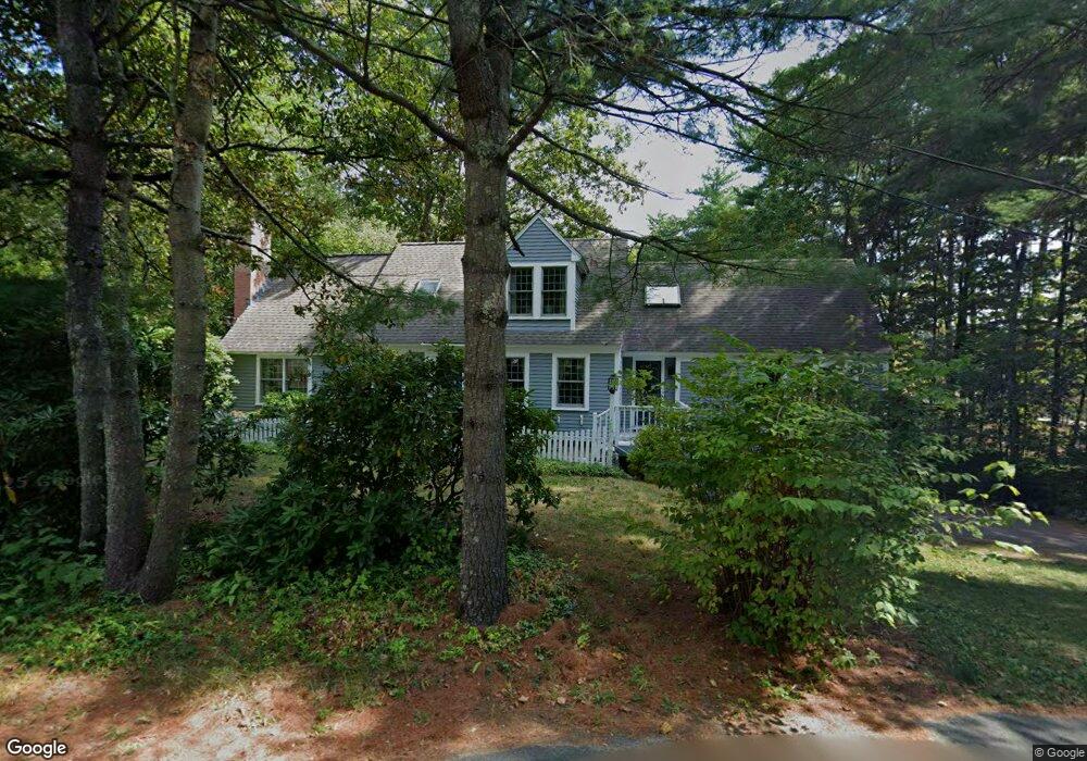
155 Arbor St Lunenburg, MA 01462
Estimated Value: $621,891 - $787,000
4
Beds
3
Baths
2,574
Sq Ft
$271/Sq Ft
Est. Value
About This Home
This home is located at 155 Arbor St, Lunenburg, MA 01462 and is currently estimated at $698,723, approximately $271 per square foot. 155 Arbor St is a home located in Worcester County with nearby schools including Lunenburg Primary School and Lunenburg High School.
Ownership History
Date
Name
Owned For
Owner Type
Purchase Details
Closed on
Jan 8, 2026
Sold by
Psg Realty 393-435 Llc
Bought by
Raudonat Ft and Raudonat
Current Estimated Value
Purchase Details
Closed on
Feb 19, 2025
Sold by
Raudonat Ft and Raudonat
Bought by
Psg Realty 393-435 Llc
Purchase Details
Closed on
Aug 26, 2021
Sold by
Raudonat John A and Raudonat Michele P
Bought by
Raudonat Ft 2021 and Raudonat
Purchase Details
Closed on
Mar 10, 1988
Sold by
Eielson John A
Bought by
Raudonat John A
Create a Home Valuation Report for This Property
The Home Valuation Report is an in-depth analysis detailing your home's value as well as a comparison with similar homes in the area
Home Values in the Area
Average Home Value in this Area
Purchase History
| Date | Buyer | Sale Price | Title Company |
|---|---|---|---|
| Raudonat Ft | $165,000 | -- | |
| Psg Realty 393-435 Llc | -- | None Available | |
| Psg Realty 393-435 Llc | -- | None Available | |
| Raydonat Ft | -- | None Available | |
| Raydonat Ft | -- | None Available | |
| Raudonat Ft 2021 | -- | None Available | |
| Raudonat Ft 2021 | -- | None Available | |
| Raudonat John A | $165,500 | -- |
Source: Public Records
Mortgage History
| Date | Status | Borrower | Loan Amount |
|---|---|---|---|
| Previous Owner | Raudonat John A | $60,000 | |
| Previous Owner | Raudonat John A | $143,200 | |
| Previous Owner | Raudonat John A | $25,000 | |
| Previous Owner | Raudonat John A | $131,000 |
Source: Public Records
Tax History
| Year | Tax Paid | Tax Assessment Tax Assessment Total Assessment is a certain percentage of the fair market value that is determined by local assessors to be the total taxable value of land and additions on the property. | Land | Improvement |
|---|---|---|---|---|
| 2025 | $7,739 | $538,900 | $141,800 | $397,100 |
| 2024 | $7,408 | $525,400 | $126,700 | $398,700 |
| 2023 | $7,464 | $510,500 | $115,200 | $395,300 |
| 2022 | $6,682 | $388,700 | $96,000 | $292,700 |
| 2020 | $7,043 | $388,700 | $96,000 | $292,700 |
| 2019 | $6,887 | $368,700 | $90,500 | $278,200 |
| 2018 | $6,531 | $331,500 | $90,500 | $241,000 |
| 2017 | $6,156 | $308,100 | $83,500 | $224,600 |
| 2016 | $5,708 | $291,100 | $79,400 | $211,700 |
| 2015 | $5,170 | $282,200 | $75,300 | $206,900 |
Source: Public Records
Map
Nearby Homes
- 12 Cortland Cir Unit 12
- 110 Burrage St
- 35 Leominster Rd
- 309 Reservoir Rd
- 601 Flat Hill Rd
- 167 S Row Rd
- 91 Valley Rd
- 11 Longwood Dr
- 36 Gilchrest St
- 63 Holman St
- 146-148 Kilburn St
- 319 Highland St
- 45 Spring St
- 711 Massachusetts Ave Unit 2
- 22 Townsend Rd
- 24 Townsend Rd
- Lot 5 Townsend Rd
- 365 Hollis Rd
- 120 Robbs Hill Rd
- 795 Leominster Rd
Your Personal Tour Guide
Ask me questions while you tour the home.