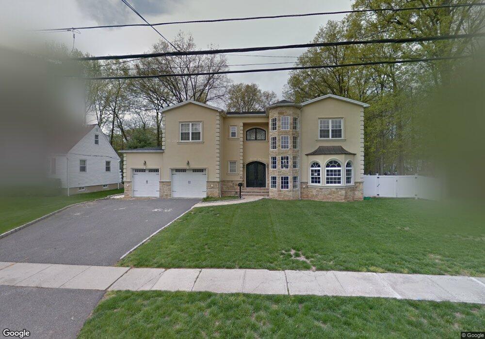
155 Denman Rd Cranford, NJ 07016
Estimated Value: $898,000 - $1,188,053
--
Bed
--
Bath
1,570
Sq Ft
$689/Sq Ft
Est. Value
About This Home
This home is located at 155 Denman Rd, Cranford, NJ 07016 and is currently estimated at $1,081,513, approximately $688 per square foot. 155 Denman Rd is a home located in Union County with nearby schools including Cranford Sr High School, St Michael School, and Mother Seton Regional High School.
Ownership History
Date
Name
Owned For
Owner Type
Purchase Details
Closed on
May 27, 2010
Sold by
Alvarez Hector and Alvarez Begonia
Bought by
Colazzo Luigi and Colazzo Franzese Rosina
Current Estimated Value
Home Financials for this Owner
Home Financials are based on the most recent Mortgage that was taken out on this home.
Original Mortgage
$300,000
Outstanding Balance
$200,171
Interest Rate
4.88%
Mortgage Type
New Conventional
Estimated Equity
$881,342
Purchase Details
Closed on
Dec 21, 2006
Sold by
Sheperis Charles W
Bought by
Alvarez Hector
Home Financials for this Owner
Home Financials are based on the most recent Mortgage that was taken out on this home.
Original Mortgage
$366,400
Interest Rate
6.24%
Mortgage Type
New Conventional
Create a Home Valuation Report for This Property
The Home Valuation Report is an in-depth analysis detailing your home's value as well as a comparison with similar homes in the area
Home Values in the Area
Average Home Value in this Area
Purchase History
| Date | Buyer | Sale Price | Title Company |
|---|---|---|---|
| Colazzo Luigi | $801,000 | Fidelity Natl Title Ins Co | |
| Alvarez Hector | $451,000 | -- |
Source: Public Records
Mortgage History
| Date | Status | Borrower | Loan Amount |
|---|---|---|---|
| Open | Colazzo Luigi | $300,000 | |
| Previous Owner | Alvarez Hector | $366,400 |
Source: Public Records
Tax History Compared to Growth
Tax History
| Year | Tax Paid | Tax Assessment Tax Assessment Total Assessment is a certain percentage of the fair market value that is determined by local assessors to be the total taxable value of land and additions on the property. | Land | Improvement |
|---|---|---|---|---|
| 2025 | $22,289 | $328,800 | $97,900 | $230,900 |
| 2024 | $20,921 | $328,800 | $97,900 | $230,900 |
| 2023 | $20,921 | $313,800 | $97,900 | $215,900 |
| 2022 | $20,748 | $313,800 | $97,900 | $215,900 |
| 2021 | $20,657 | $313,800 | $97,900 | $215,900 |
| 2020 | $20,592 | $313,800 | $97,900 | $215,900 |
| 2019 | $20,460 | $313,800 | $97,900 | $215,900 |
| 2018 | $20,089 | $313,800 | $97,900 | $215,900 |
| 2017 | $19,399 | $313,800 | $97,900 | $215,900 |
| 2016 | $18,693 | $313,800 | $97,900 | $215,900 |
| 2015 | $18,204 | $313,800 | $97,900 | $215,900 |
| 2014 | $17,830 | $313,800 | $97,900 | $215,900 |
Source: Public Records
Map
Nearby Homes
- 113 Retford Ave
- 2 Pine St
- 45 Hillcrest Ave
- 19 Hawthorne St
- 247 Walnut Ave
- 108 James Ave
- 211 High St
- 37 Broad St
- 1 Broad St
- 10 Alan O Kell Place
- 11 Mendell Ave
- 166 N Lehigh Ave
- 59 Willow Ave
- 213 North Ave W
- 383 Lincoln Ave E
- 205 Locust Ave
- 110 Lincoln Park E
- 76 Centennial Ave
- 219 Centennial Ave Unit B
- 113 Winslow Place Unit 3