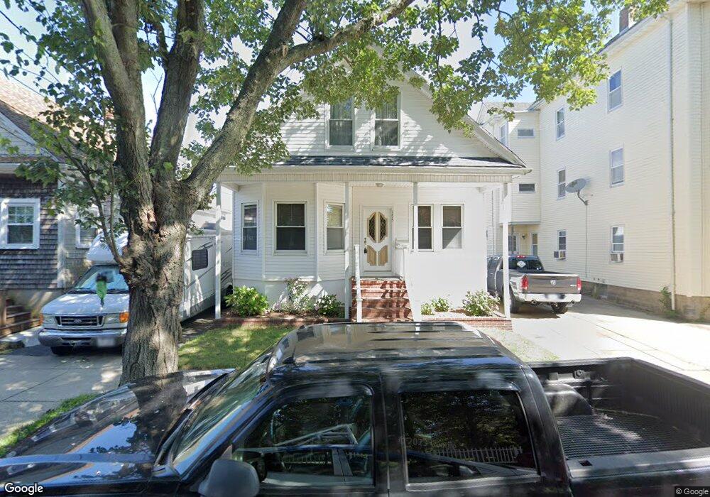
155 Hudson St New Bedford, MA 02744
The South End NeighborhoodEstimated Value: $425,262 - $486,000
4
Beds
2
Baths
1,356
Sq Ft
$335/Sq Ft
Est. Value
About This Home
This home is located at 155 Hudson St, New Bedford, MA 02744 and is currently estimated at $454,566, approximately $335 per square foot. 155 Hudson St is a home located in Bristol County with nearby schools including William H. Taylor Elementary School, Roosevelt Middle School, and New Bedford High School.
Ownership History
Date
Name
Owned For
Owner Type
Purchase Details
Closed on
Dec 16, 1999
Sold by
Martins Antonio N
Bought by
Nogueira Jorge H
Current Estimated Value
Create a Home Valuation Report for This Property
The Home Valuation Report is an in-depth analysis detailing your home's value as well as a comparison with similar homes in the area
Home Values in the Area
Average Home Value in this Area
Purchase History
| Date | Buyer | Sale Price | Title Company |
|---|---|---|---|
| Nogueira Jorge H | $89,000 | -- | |
| Nogueira Jorge H | $89,000 | -- |
Source: Public Records
Mortgage History
| Date | Status | Borrower | Loan Amount |
|---|---|---|---|
| Open | Nogueira Jorge H | $151,655 | |
| Closed | Nogueira Jorge H | $162,500 | |
| Closed | Nogueira Jorge H | $109,500 |
Source: Public Records
Tax History Compared to Growth
Tax History
| Year | Tax Paid | Tax Assessment Tax Assessment Total Assessment is a certain percentage of the fair market value that is determined by local assessors to be the total taxable value of land and additions on the property. | Land | Improvement |
|---|---|---|---|---|
| 2025 | $4,318 | $381,800 | $110,700 | $271,100 |
| 2024 | $4,018 | $334,800 | $104,300 | $230,500 |
| 2023 | $4,334 | $303,300 | $89,800 | $213,500 |
| 2022 | $3,938 | $253,400 | $81,800 | $171,600 |
| 2021 | $11,274 | $244,800 | $81,800 | $163,000 |
| 2020 | $3,722 | $230,300 | $81,800 | $148,500 |
| 2019 | $3,652 | $214,100 | $81,800 | $132,300 |
| 2018 | $5,417 | $199,400 | $81,800 | $117,600 |
| 2017 | $3,106 | $186,100 | $81,800 | $104,300 |
| 2016 | $2,932 | $177,800 | $78,600 | $99,200 |
| 2015 | $2,636 | $167,600 | $73,800 | $93,800 |
| 2014 | $2,379 | $156,900 | $73,800 | $83,100 |
Source: Public Records
Map
Nearby Homes
- 151 Hudson St
- 159 Hudson St
- 163 Hudson St
- 168 Portland St
- 147 Hudson St
- 162 Portland St
- 176 Portland St
- 171 Hudson St
- 152 Hudson St
- 65 Brock Ave
- 184 Portland St
- 75 Brock Ave
- 174 Hudson St
- 167 Portland St
- 175 Portland St
- 179 Portland St
- 28 Point St
- 51 Brock Ave Unit 10
- 51 Brock Ave Unit 1
- 192 Portland St