Estimated Value: $803,802 - $935,000
--
Bed
--
Bath
2,074
Sq Ft
$410/Sq Ft
Est. Value
About This Home
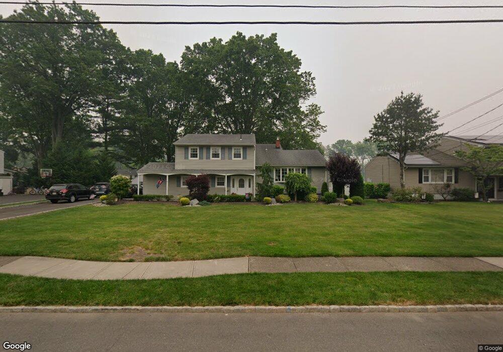
This home is located at 155 Jupitor St, Clark, NJ 07066 and is currently estimated at $851,201, approximately $410 per square foot. 155 Jupitor St is a home located in Union County with nearby schools including Frank K. Hehnly Elementary School, Carl H. Kumpf Middle School, and Arthur L. Johnson High School.
Ownership History
Date
Name
Owned For
Owner Type
Purchase Details
Closed on
Jan 19, 2001
Sold by
Walsh Vincent D
Bought by
Markowski Duane T and Markowski Maureen
Current Estimated Value
Home Financials for this Owner
Home Financials are based on the most recent Mortgage that was taken out on this home.
Original Mortgage
$100,000
Outstanding Balance
$2,145
Interest Rate
7.25%
Mortgage Type
Stand Alone First
Estimated Equity
$849,056
Purchase Details
Closed on
Sep 20, 2000
Sold by
Marcinak Marion
Bought by
Walsh Vincent D
Purchase Details
Closed on
Mar 18, 1997
Sold by
Walsh Vincent D and Walsh Daniel S
Bought by
Walsh Vincent D and Walsh Daniel S
Purchase Details
Closed on
Mar 18, 1994
Sold by
Walsh Vincent D
Bought by
Walsh Daniel S and Walsh Vincent D
Home Financials for this Owner
Home Financials are based on the most recent Mortgage that was taken out on this home.
Original Mortgage
$100,000
Interest Rate
7.6%
Create a Home Valuation Report for This Property
The Home Valuation Report is an in-depth analysis detailing your home's value as well as a comparison with similar homes in the area
Home Values in the Area
Average Home Value in this Area
Purchase History
| Date | Buyer | Sale Price | Title Company |
|---|---|---|---|
| Markowski Duane T | $274,500 | Chicago Title Insurance Co | |
| Walsh Vincent D | -- | -- | |
| Walsh Vincent D | -- | -- | |
| Walsh Daniel S | $122,500 | -- |
Source: Public Records
Mortgage History
| Date | Status | Borrower | Loan Amount |
|---|---|---|---|
| Open | Markowski Duane T | $100,000 | |
| Previous Owner | Walsh Daniel S | $100,000 |
Source: Public Records
Tax History Compared to Growth
Tax History
| Year | Tax Paid | Tax Assessment Tax Assessment Total Assessment is a certain percentage of the fair market value that is determined by local assessors to be the total taxable value of land and additions on the property. | Land | Improvement |
|---|---|---|---|---|
| 2025 | $14,105 | $637,100 | $340,000 | $297,100 |
| 2024 | $13,895 | $637,100 | $340,000 | $297,100 |
| 2023 | $13,895 | $637,100 | $340,000 | $297,100 |
| 2022 | $13,494 | $637,100 | $340,000 | $297,100 |
| 2021 | $12,099 | $136,100 | $52,100 | $84,000 |
| 2020 | $11,902 | $136,100 | $52,100 | $84,000 |
| 2019 | $11,782 | $136,100 | $52,100 | $84,000 |
| 2018 | $11,560 | $136,100 | $52,100 | $84,000 |
| 2017 | $11,454 | $136,100 | $52,100 | $84,000 |
| 2016 | $11,032 | $136,100 | $52,100 | $84,000 |
| 2015 | $10,921 | $136,100 | $52,100 | $84,000 |
| 2014 | $10,691 | $136,100 | $52,100 | $84,000 |
Source: Public Records
Map
Nearby Homes
- 19 State St
- 39 Mildred Terrace
- 675 Raritan Rd Unit 33
- 116 Arthur Ave
- 54 Morningside Rd
- 205 Patricia Ave
- 74 Westminster Rd
- 70 Lancaster Rd
- 24 Frederick Ave
- 99 Cameo Place
- 44 Post Rd
- 5 Elizabeth Ct
- 78 Patricia Ave
- 150 Carolyn Ave
- 3 Mckinley Ave
- 131 Morningside Rd
- 54 White Place
- 107 Meadow Rd
- 81 White Place
- 25 N Lincoln Ave