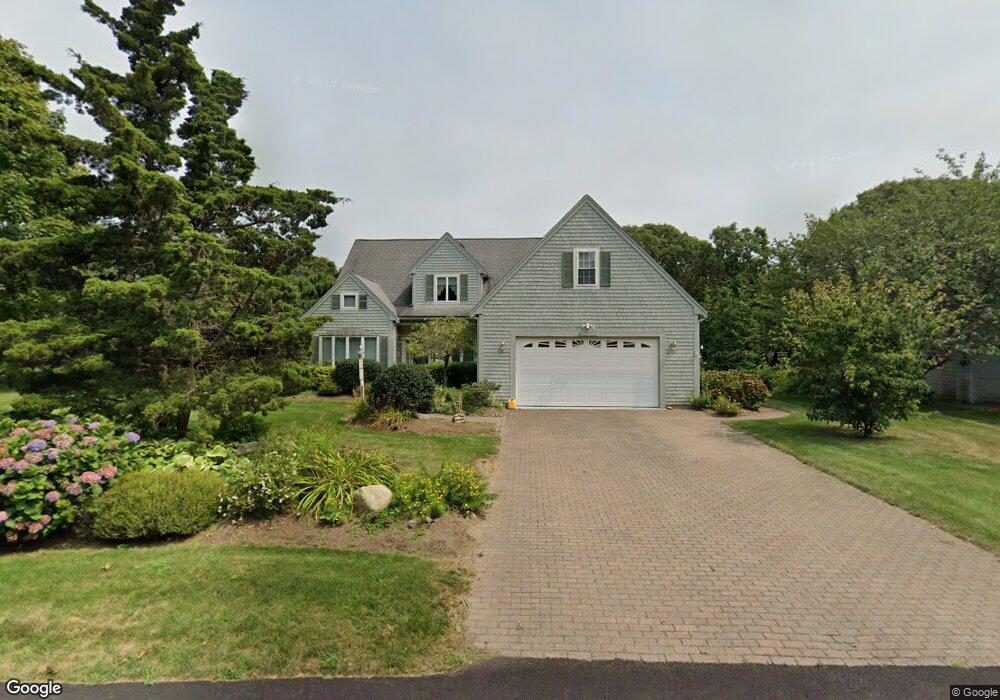
155 Quail Cover Ln Eastham, MA 02642
Estimated Value: $841,000 - $984,000
3
Beds
3
Baths
2,081
Sq Ft
$446/Sq Ft
Est. Value
About This Home
This home is located at 155 Quail Cover Ln, Eastham, MA 02642 and is currently estimated at $928,094, approximately $445 per square foot. 155 Quail Cover Ln is a home located in Barnstable County with nearby schools including Eastham Elementary School, Nauset Regional Middle School, and Nauset Regional High School.
Ownership History
Date
Name
Owned For
Owner Type
Purchase Details
Closed on
Feb 19, 2024
Sold by
Evelyn Preservati Ret and Preservati
Bought by
155 Quail Cover Lane Rt and Preservati
Current Estimated Value
Purchase Details
Closed on
Jun 13, 1997
Sold by
Bruno Donald and Bruno Jacqueline M
Bought by
Preservati Richar J and Preservati Evelyn L
Create a Home Valuation Report for This Property
The Home Valuation Report is an in-depth analysis detailing your home's value as well as a comparison with similar homes in the area
Home Values in the Area
Average Home Value in this Area
Purchase History
We collect this data history from publicly available records. To have your information removed, we recommend requesting removal directly through your county’s website.
| Date | Buyer | Sale Price | Title Company |
|---|---|---|---|
| 155 Quail Cover Lane Rt | -- | None Available | |
| 155 Quail Cover Lane Rt | -- | None Available | |
| Preservati Richar J | $49,500 | -- | |
| Preservati Richar J | $49,500 | -- |
Source: Public Records
Tax History
| Year | Tax Paid | Tax Assessment Tax Assessment Total Assessment is a certain percentage of the fair market value that is determined by local assessors to be the total taxable value of land and additions on the property. | Land | Improvement |
|---|---|---|---|---|
| 2025 | $6,863 | $890,100 | $273,900 | $616,200 |
| 2024 | $6,055 | $863,700 | $265,900 | $597,800 |
| 2023 | $5,601 | $773,600 | $246,200 | $527,400 |
| 2022 | $5,126 | $597,400 | $219,800 | $377,600 |
| 2021 | $5,024 | $547,300 | $199,800 | $347,500 |
| 2020 | $4,615 | $529,300 | $203,900 | $325,400 |
| 2019 | $4,272 | $517,800 | $198,000 | $319,800 |
| 2018 | $4,200 | $503,000 | $192,200 | $310,800 |
| 2017 | $3,925 | $496,800 | $188,500 | $308,300 |
| 2016 | $3,445 | $463,100 | $160,200 | $302,900 |
| 2015 | $3,229 | $454,800 | $157,100 | $297,700 |
Source: Public Records
Map
Nearby Homes
- 125 Wamsutta Rd
- 95 Toland Dr
- 5470 State Hwy
- 495 Aspinet Rd
- 25 Oakwood Rd
- 18 Jay Dee Ln
- 190 Serb St
- 1295 Massasoit Rd
- 1230 Massasoit Rd
- 50 Silver Oak Rd
- 11 Whelpley Rd
- 311 S Sunken Meadow Rd
- 2560 Nauset Rd
- 20 Oak Rd
- 190 Silver Spring Beach Rd
- 111 Spring Brook Rd
- 255 Epanow Rd
- 65 Harmes Way
- 300 Brackett Rd
- 90 Rolling Ln
- 65 Quail Cover Ln
- 175 Quail Cover Ln
- 140 Quail Cover Ln
- 90 Quail Cover Ln
- 160 Quail Cover Ln
- 120 Quail Cover Ln
- 205 Quail Cover Ln
- 45 Quail Cover Ln
- 60 Quail Cover Ln
- 4 Quarterboard Ln
- 4 Shortys Way
- 11 Shortys Way
- 3 Quarterboard Ln
- 4 Shorty's Way
- 40 Quail Cover Ln
- 235 Quail Cover Ln
- 150 N Sunken Meadow Rd
- 2 Quarterboard Ln
- 210 Quail Cover Ln
- 125 Leeward Way
Your Personal Tour Guide
Ask me questions while you tour the home.