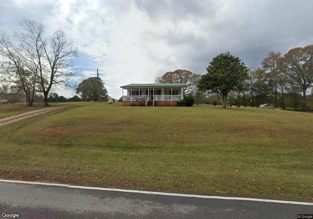
1550 Smokey Rd Lagrange, GA 30241
Estimated Value: $184,000 - $263,000
2
Beds
1
Bath
1,660
Sq Ft
$130/Sq Ft
Est. Value
About This Home
This home is located at 1550 Smokey Rd, Lagrange, GA 30241 and is currently estimated at $215,160, approximately $129 per square foot. 1550 Smokey Rd is a home located in Troup County with nearby schools including Rosemont Elementary School, Whitesville Road Elementary School, and Berta Weathersbee Elementary School.
Ownership History
Date
Name
Owned For
Owner Type
Purchase Details
Closed on
Aug 19, 1999
Sold by
Connie Lee and Connie Bridges
Bought by
Swanson Kenneth L
Current Estimated Value
Purchase Details
Closed on
Jul 27, 1997
Sold by
Swanson Kenneth and Swanson
Bought by
Connie Lee and Connie Bridges
Purchase Details
Closed on
Mar 11, 1977
Bought by
Swanson Kenneth and Swanson
Purchase Details
Closed on
May 6, 1976
Purchase Details
Closed on
Jan 2, 1972
Purchase Details
Closed on
Oct 1, 1970
Purchase Details
Closed on
Jan 2, 1968
Create a Home Valuation Report for This Property
The Home Valuation Report is an in-depth analysis detailing your home's value as well as a comparison with similar homes in the area
Home Values in the Area
Average Home Value in this Area
Purchase History
| Date | Buyer | Sale Price | Title Company |
|---|---|---|---|
| Swanson Kenneth L | -- | -- | |
| Connie Lee | -- | -- | |
| Swanson Kenneth | -- | -- | |
| -- | -- | -- | |
| -- | -- | -- | |
| -- | -- | -- | |
| -- | -- | -- |
Source: Public Records
Tax History Compared to Growth
Tax History
| Year | Tax Paid | Tax Assessment Tax Assessment Total Assessment is a certain percentage of the fair market value that is determined by local assessors to be the total taxable value of land and additions on the property. | Land | Improvement |
|---|---|---|---|---|
| 2024 | $632 | $50,076 | $7,440 | $42,636 |
| 2023 | $342 | $38,424 | $7,440 | $30,984 |
| 2022 | $342 | $36,424 | $7,440 | $28,984 |
| 2021 | $300 | $30,528 | $6,840 | $23,688 |
| 2020 | $669 | $32,128 | $7,280 | $24,848 |
| 2019 | $666 | $32,040 | $7,280 | $24,760 |
| 2018 | $599 | $29,804 | $7,280 | $22,524 |
| 2017 | $599 | $29,804 | $7,280 | $22,524 |
| 2016 | $578 | $29,090 | $7,300 | $21,790 |
| 2015 | $581 | $29,090 | $7,300 | $21,790 |
| 2014 | $547 | $27,943 | $7,300 | $20,643 |
| 2013 | -- | $29,645 | $7,300 | $22,345 |
Source: Public Records
Map
Nearby Homes
- 430 Briley Rd
- 37.23 ACRES / 0 Smokey Rd
- 0 Smokey Rd Unit 10570471
- 0 Jim Perry Rd Unit 25773088
- 0 Briley Rd Unit 10582531
- 0 Briley Rd Unit 214353
- 783 Rosemont Rd
- 5656 Hamilton Rd
- 5656 Hamilton Rd
- 15 Frost School Rd
- 119 Robertson Rd
- 137 Robertson Rd
- 737 John Lovelace Rd
- 3919 Hamilton Rd Unit LOT 1
- 401 Lower Big Springs Rd Unit LOT 1
- 670 Lower Big Springs Rd
- 186 Old Chipley Rd
- 113 Glenn Eagle Point
- 417 Tucker Rd
- 3691 Hamilton Rd
- 1594 Smokey Rd
- 622 Briley Rd
- 580 Briley Rd
- 676 Briley Rd
- 1626 Smokey Rd
- 1469 Smokey Rd
- 651 Briley Rd
- 1620 Smokey Rd
- 546 Briley Rd
- 718 Briley Rd
- 1665 Smokey Rd
- 525 Briley Rd
- 1650 Smokey Rd
- 1715 Smokey Rd
- 1680 Smokey Rd
- 1733 Smokey Rd
- 1388 Smokey Rd
- 1739 Smokey Rd
- 430 Briley Rd Unit TRACT 1
- 1363 Smokey Rd