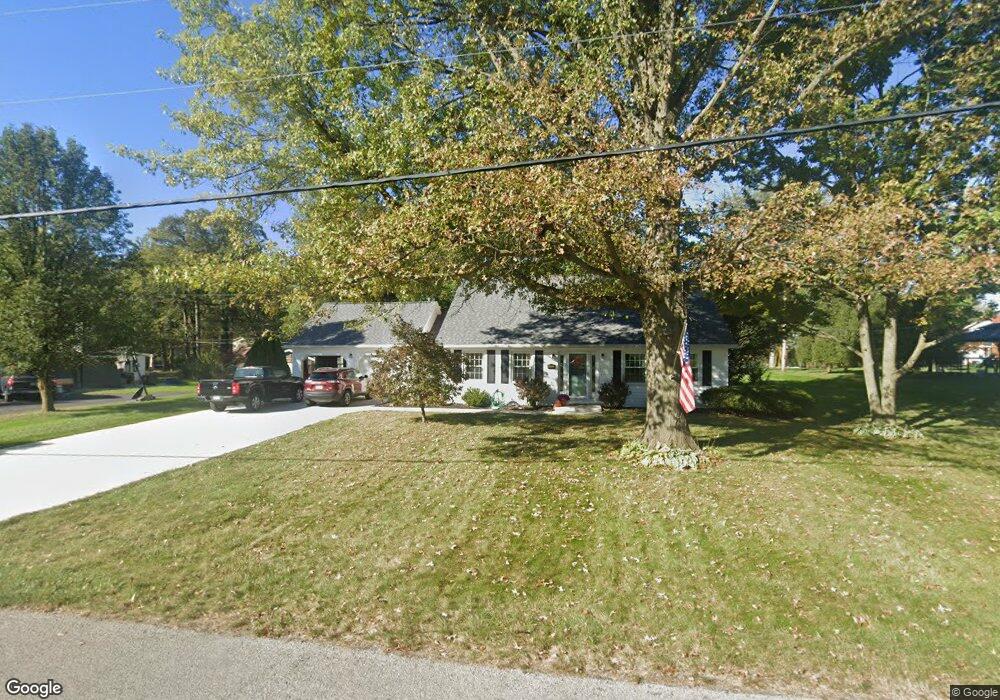
1552 Bunker Dr Lima, OH 45805
Estimated Value: $292,000 - $330,000
4
Beds
3
Baths
2,448
Sq Ft
$127/Sq Ft
Est. Value
About This Home
This home is located at 1552 Bunker Dr, Lima, OH 45805 and is currently estimated at $309,676, approximately $126 per square foot. 1552 Bunker Dr is a home located in Allen County with nearby schools including Maplewood Elementary School, Elmwood Elementary School, and Shawnee Middle School.
Ownership History
Date
Name
Owned For
Owner Type
Purchase Details
Closed on
Nov 26, 1996
Sold by
Waldowski Donald
Bought by
Apkarian Kyle and Apkarian Penelope
Current Estimated Value
Home Financials for this Owner
Home Financials are based on the most recent Mortgage that was taken out on this home.
Original Mortgage
$112,000
Outstanding Balance
$11,632
Interest Rate
7.94%
Mortgage Type
New Conventional
Estimated Equity
$298,044
Purchase Details
Closed on
Nov 6, 1995
Sold by
Tebben Thomas
Bought by
Waldowski Donald and Waldowski Betty
Home Financials for this Owner
Home Financials are based on the most recent Mortgage that was taken out on this home.
Original Mortgage
$118,450
Interest Rate
7.5%
Mortgage Type
VA
Purchase Details
Closed on
Apr 11, 1985
Bought by
Tebben Thomas R
Create a Home Valuation Report for This Property
The Home Valuation Report is an in-depth analysis detailing your home's value as well as a comparison with similar homes in the area
Purchase History
| Date | Buyer | Sale Price | Title Company |
|---|---|---|---|
| Apkarian Kyle | $118,000 | -- | |
| Waldowski Donald | $115,000 | -- | |
| Tebben Thomas R | $60,000 | -- |
Source: Public Records
Mortgage History
| Date | Status | Borrower | Loan Amount |
|---|---|---|---|
| Open | Apkarian Kyle | $112,000 | |
| Previous Owner | Waldowski Donald | $118,450 |
Source: Public Records
Tax History
| Year | Tax Paid | Tax Assessment Tax Assessment Total Assessment is a certain percentage of the fair market value that is determined by local assessors to be the total taxable value of land and additions on the property. | Land | Improvement |
|---|---|---|---|---|
| 2024 | $3,688 | $75,710 | $17,290 | $58,420 |
| 2023 | $3,400 | $61,570 | $14,070 | $47,500 |
| 2022 | $3,426 | $61,570 | $14,070 | $47,500 |
| 2021 | $3,442 | $61,570 | $14,070 | $47,500 |
| 2020 | $2,427 | $50,300 | $13,370 | $36,930 |
| 2019 | $2,427 | $50,300 | $13,370 | $36,930 |
| 2018 | $2,337 | $50,300 | $13,370 | $36,930 |
| 2017 | $2,256 | $45,470 | $13,370 | $32,100 |
| 2016 | $2,237 | $45,470 | $13,370 | $32,100 |
| 2015 | $2,264 | $45,470 | $13,370 | $32,100 |
| 2014 | $2,264 | $45,440 | $12,850 | $32,590 |
| 2013 | $2,220 | $45,440 | $12,850 | $32,590 |
Source: Public Records
Map
Nearby Homes
- 115 Lanes End
- 2970 Sands Rd
- 3220 Fort Amanda Rd
- 1540 Adak Ave
- 1453 W Shore Dr
- 2632 Alexandria Dr
- 2529 Struthmore Dr
- 1408 Winghaven Dr
- 5 Estate Dr
- 2 Estate Dr
- 6 Estate Dr
- 1 Estate Dr
- 3390 Spencerville Rd
- 1635 Tanglewood Ln
- 1421 Shawnee Rd
- 2852 Riverwalk Blvd Unit 2852
- 1602 Wonderlick Rd
- 2 Parcel Zurmehly Land Package
- 250 Squire Ln
- 4211 Fort Amanda Rd
Your Personal Tour Guide
Ask me questions while you tour the home.