Estimated Value: $347,990 - $793,000
--
Bed
--
Bath
--
Sq Ft
7,144
Sq Ft Lot
About This Home
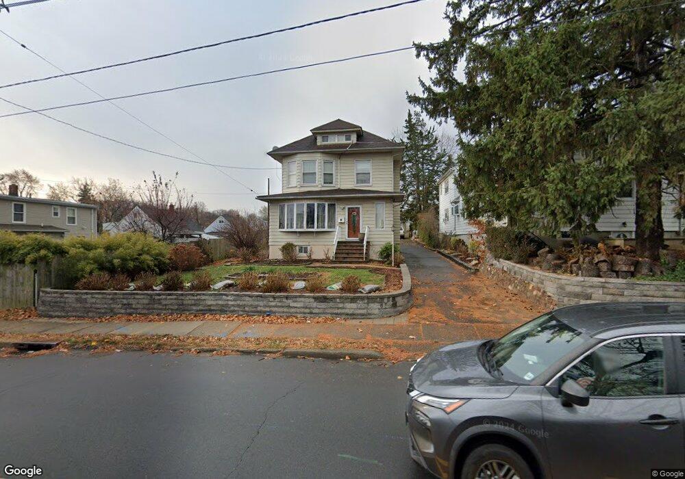
This home is located at 1552 Vauxhall Rd, Union, NJ 07083 and is currently estimated at $600,748. 1552 Vauxhall Rd is a home located in Union County with nearby schools including Livingston Elementary School, Union High School, and St Michael Parish School.
Ownership History
Date
Name
Owned For
Owner Type
Purchase Details
Closed on
Apr 3, 2003
Sold by
Hud
Bought by
Calero Isabel and Calero Pedro
Current Estimated Value
Home Financials for this Owner
Home Financials are based on the most recent Mortgage that was taken out on this home.
Original Mortgage
$262,200
Outstanding Balance
$111,729
Interest Rate
5.64%
Estimated Equity
$489,019
Purchase Details
Closed on
Jul 15, 1997
Sold by
Bucci Rudolph and Bucci Margaret
Bought by
Register Robert E
Home Financials for this Owner
Home Financials are based on the most recent Mortgage that was taken out on this home.
Original Mortgage
$155,931
Interest Rate
7.55%
Mortgage Type
FHA
Create a Home Valuation Report for This Property
The Home Valuation Report is an in-depth analysis detailing your home's value as well as a comparison with similar homes in the area
Home Values in the Area
Average Home Value in this Area
Purchase History
| Date | Buyer | Sale Price | Title Company |
|---|---|---|---|
| Calero Isabel | $276,000 | -- | |
| Register Robert E | $158,500 | First American |
Source: Public Records
Mortgage History
| Date | Status | Borrower | Loan Amount |
|---|---|---|---|
| Open | Calero Isabel | $262,200 | |
| Previous Owner | Register Robert E | $155,931 |
Source: Public Records
Tax History Compared to Growth
Tax History
| Year | Tax Paid | Tax Assessment Tax Assessment Total Assessment is a certain percentage of the fair market value that is determined by local assessors to be the total taxable value of land and additions on the property. | Land | Improvement |
|---|---|---|---|---|
| 2025 | $12,293 | $55,000 | $21,100 | $33,900 |
| 2024 | $11,918 | $55,000 | $21,100 | $33,900 |
| 2023 | $11,918 | $55,000 | $21,100 | $33,900 |
| 2022 | $11,504 | $55,000 | $21,100 | $33,900 |
| 2021 | $11,225 | $55,000 | $21,100 | $33,900 |
| 2020 | $11,001 | $55,000 | $21,100 | $33,900 |
| 2019 | $10,853 | $55,000 | $21,100 | $33,900 |
| 2018 | $10,668 | $55,000 | $21,100 | $33,900 |
| 2017 | $10,511 | $55,000 | $21,100 | $33,900 |
| 2016 | $10,254 | $55,000 | $21,100 | $33,900 |
| 2015 | $10,084 | $55,000 | $21,100 | $33,900 |
| 2014 | $9,858 | $55,000 | $21,100 | $33,900 |
Source: Public Records
Map
Nearby Homes
- 1267 Erhardt St
- 1040 Cranbrook Rd
- 1393 Cornell Place
- 142 Eastern Pkwy
- 286 Mclean Place
- 1322 Marcella Dr
- 553 Harvard Ave
- 557 Yale Ave
- 617 Tillman St
- 542 Leo St
- 112 Apple Tree Ln
- 537 Us Highway 22
- 525 Us Highway 22
- 507 Locust Ave
- 35 Eastern Pkwy
- 1370 Beverly Rd
- 1764 Colgate Place
- 314 Fitzpatrick St
- 1848 Portsmouth Way
- 393 Harvard Ave
- 1185 Harmony Rd
- 2000 Patton Rd
- 1992 Patton Rd
- 1177 Harmony Rd
- 1988 Patton Rd
- 1173 Harmony Rd
- 1539 Vauxhall Rd
- 1186 Harmony Rd
- 1547 Vauxhall Rd
- 1207 Robert St
- 1182 Harmony Rd
- 1982 Patton Rd
- 1169 Harmony Rd
- 1190 Harmony Rd
- 1178 Harmony Rd
- 1535 Vauxhall Rd
- 1075 Susan Place
- 1211 Robert St
- 2001 Patton Rd
- 1995 Patton Rd