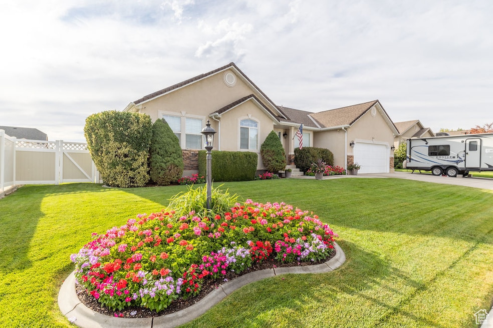
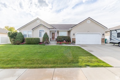
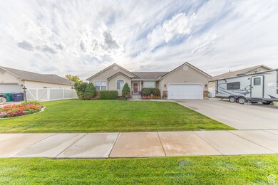
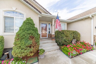
1553 N 250 E Layton, UT 84041
Estimated payment $3,520/month
Highlights
- Second Kitchen
- Solar Power System
- Rambler Architecture
- RV or Boat Parking
- Vaulted Ceiling
- 4-minute walk to Woodward Park
About This Home
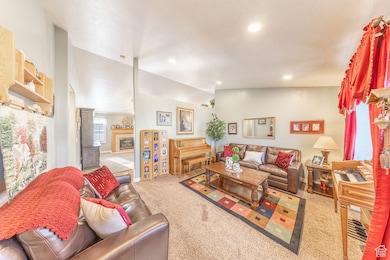
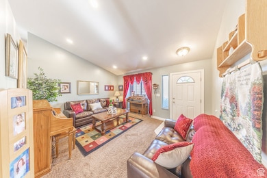
IMMACULATE AND MOVE-IN READY, this 6-bedroom, 3-bath rambler sits in a quiet Layton cul-de-sac just 5 minutes from the South entrance of Hill Air Force Base and offers over 3,300 square feet of versatile living space. The home's thoughtful layout includes two full kitchens with ranges, refrigerators, microwaves, and dishwashers, plus two laundry hookups, making the basement perfect for a separate apartment, extended family, or rental income. Pride of ownership is evident throughout, with a 2-year-old roof, a solar system that averages 30,000 watts/day in summer to cover most of the electric bill, and no deferred maintenance. Outside, enjoy beautifully manicured flower gardens, six large vinyl raised garden beds, and a spacious 16x20 covered patio ideal for morning coffee, summer barbecues, or evening gatherings. The fully fenced backyard also features a powered 10x20 shed with lighting, a full-length RV pad, and convenient gates on both sides of the home. Permanent Govee holiday lighting along the roofline adds year-round charm, while the expansive yard and outdoor spaces provide a perfect backdrop for gardening, entertaining, or simply relaxing in a peaceful setting.

Co-Listing Agent
Stephen Stringham
Equity Real Estate (Select) License #5551694
Home Details
Home Type
- Single Family
Est. Annual Taxes
- $2,782
Year Built
- Built in 2001
Lot Details
- 8,276 Sq Ft Lot
- Cul-De-Sac
- Property is Fully Fenced
- Landscaped
- Sprinkler System
- Vegetable Garden
- Property is zoned Single-Family, R-1-8
Parking
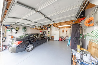
- 2 Car Attached Garage
- RV or Boat Parking
Home Design
- Rambler Architecture
- Stone Siding
- Stucco
Interior Spaces
- 3,314 Sq Ft Home
- 2-Story Property
- Vaulted Ceiling
- Ceiling Fan
- Gas Log Fireplace
- Double Pane Windows
- Plantation Shutters
- Blinds
- Sliding Doors
- Great Room
- Storm Doors
- Electric Dryer Hookup
Kitchen
- Second Kitchen
- Gas Range
- Free-Standing Range
- Microwave
- Disposal
Flooring
- Carpet
- Tile
Bedrooms and Bathrooms
- 6 Bedrooms | 3 Main Level Bedrooms
- Primary Bedroom on Main
- Walk-In Closet
- 3 Full Bathrooms
- Hydromassage or Jetted Bathtub
- Bathtub With Separate Shower Stall
Basement
- Basement Fills Entire Space Under The House
- Apartment Living Space in Basement
Eco-Friendly Details
- Solar Power System
- Solar owned by seller
Outdoor Features
- Covered Patio or Porch
- Storage Shed
- Outbuilding
Schools
- Lincoln Elementary School
- North Layton Middle School
- Northridge High School
Utilities
- Forced Air Heating and Cooling System
- Natural Gas Connected
Community Details
- No Home Owners Association
Listing and Financial Details
- Exclusions: Dryer, Freezer, Gas Grill/BBQ, Range, Range Hood, Refrigerator, Washer, Window Coverings
- Assessor Parcel Number 10-210-0224
Map
Home Values in the Area
Average Home Value in this Area
Tax History
| Year | Tax Paid | Tax Assessment Tax Assessment Total Assessment is a certain percentage of the fair market value that is determined by local assessors to be the total taxable value of land and additions on the property. | Land | Improvement |
|---|---|---|---|---|
| 2025 | $2,782 | $292,050 | $100,178 | $191,872 |
| 2024 | $2,663 | $281,601 | $116,837 | $164,764 |
| 2023 | $2,667 | $497,000 | $139,920 | $357,080 |
| 2022 | $2,793 | $282,700 | $74,266 | $208,434 |
| 2021 | $2,570 | $388,000 | $103,826 | $284,174 |
| 2020 | $2,465 | $357,000 | $87,509 | $269,491 |
| 2019 | $2,439 | $346,000 | $83,247 | $262,753 |
| 2018 | $2,219 | $316,000 | $83,247 | $232,753 |
| 2016 | $2,079 | $152,735 | $26,501 | $126,234 |
| 2015 | $1,984 | $138,325 | $26,501 | $111,824 |
| 2014 | $1,978 | $141,067 | $26,501 | $114,566 |
| 2013 | -- | $123,602 | $33,088 | $90,514 |
Property History
| Date | Event | Price | List to Sale | Price per Sq Ft |
|---|---|---|---|---|
| 10/19/2025 10/19/25 | Pending | -- | -- | -- |
| 10/01/2025 10/01/25 | For Sale | $625,000 | -- | $189 / Sq Ft |
Purchase History
| Date | Type | Sale Price | Title Company |
|---|---|---|---|
| Interfamily Deed Transfer | -- | None Available | |
| Corporate Deed | -- | -- | |
| Corporate Deed | -- | -- |
Mortgage History
| Date | Status | Loan Amount | Loan Type |
|---|---|---|---|
| Open | $110,000 | No Value Available |
Source: UtahRealEstate.com
MLS Number: 2114784
APN: 10-210-0224
Disclaimer: Certain information contained herein is derived from information provided by parties other than Homes.com. All information provided is deemed reliable, but is not guaranteed to be accurate and should be independently verified.
![]() IDX information is provided exclusively for consumers’ personal, non-commercial use, that it may not be used for any purpose other than to identify prospective properties consumers may be interested in purchasing, and that the data is deemed reliable but is not guaranteed accurate by the MLS. Licensor is only providing the MLS Content and not other sources of data provided in the Product.
IDX information is provided exclusively for consumers’ personal, non-commercial use, that it may not be used for any purpose other than to identify prospective properties consumers may be interested in purchasing, and that the data is deemed reliable but is not guaranteed accurate by the MLS. Licensor is only providing the MLS Content and not other sources of data provided in the Product.
Based on information from the Wasatch Front Regional Multiple Listing Service, Inc.. All data, including all measurements and calculations of area, is obtained from various sources and has not been, and will not be, verified by broker or the MLS. All information should be independently reviewed and verified for accuracy. Properties may or may not be listed by the office/agent presenting the information.
- 1474 N 285 E
- 324 E 1325 N
- 1490 N 175 W
- 1966 N 50 W
- 1908 N 200 W
- 2044 Evans Cove Loop
- 1131 N 150 W
- 2048 Evans Cove Loop
- 9 W 2150 N
- 23 E 2150 N
- 398 Paul Ave
- 1837 N 440 W
- 937 Rainbow Dr
- 979 E Frost Way
- 3450 N Fairfield Rd Unit 3
- 785 Sherwood Dr
- 95 W 2400 N
- 712 E Aspen East Dr
- 806 Valeria Dr
- 794 Valeria Dr