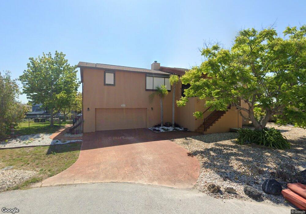
15532 Bertram Dr Hudson, FL 34667
Estimated Value: $356,000 - $663,000
Studio
2
Baths
1,886
Sq Ft
$282/Sq Ft
Est. Value
About This Home
This home is located at 15532 Bertram Dr, Hudson, FL 34667 and is currently estimated at $532,726, approximately $282 per square foot. 15532 Bertram Dr is a home located in Pasco County with nearby schools including West Pasco Education Academy, Hudson Middle School, and Hudson High School.
Ownership History
Date
Name
Owned For
Owner Type
Purchase Details
Closed on
Mar 12, 2001
Sold by
Toepi Inc C
Bought by
Rousell Dennis and Rousell Viki
Current Estimated Value
Purchase Details
Closed on
Jan 9, 1995
Sold by
Errico William and Errico Yolanda
Bought by
Rousell Dennis M and Rousell Viki T
Home Financials for this Owner
Home Financials are based on the most recent Mortgage that was taken out on this home.
Original Mortgage
$134,300
Interest Rate
9.2%
Mortgage Type
Purchase Money Mortgage
Create a Home Valuation Report for This Property
The Home Valuation Report is an in-depth analysis detailing your home's value as well as a comparison with similar homes in the area
Home Values in the Area
Average Home Value in this Area
Purchase History
| Date | Buyer | Sale Price | Title Company |
|---|---|---|---|
| Rousell Dennis | $26,000 | -- | |
| Rousell Dennis M | $167,900 | -- |
Source: Public Records
Mortgage History
| Date | Status | Borrower | Loan Amount |
|---|---|---|---|
| Open | Rousell Dennis | $100,000 | |
| Closed | Rousell Dennis | $59,200 | |
| Previous Owner | Rousell Dennis M | $134,300 |
Source: Public Records
Tax History
| Year | Tax Paid | Tax Assessment Tax Assessment Total Assessment is a certain percentage of the fair market value that is determined by local assessors to be the total taxable value of land and additions on the property. | Land | Improvement |
|---|---|---|---|---|
| 2026 | $3,211 | $232,060 | -- | -- |
| 2025 | $3,211 | $232,060 | -- | -- |
| 2024 | $3,211 | $218,260 | -- | -- |
| 2023 | $3,088 | $211,910 | $0 | $0 |
| 2022 | $2,769 | $205,740 | $0 | $0 |
| 2021 | $2,713 | $199,750 | $132,323 | $67,427 |
| 2020 | $2,667 | $197,000 | $125,319 | $71,681 |
| 2019 | $2,611 | $192,090 | $0 | $0 |
| 2018 | $2,559 | $188,517 | $0 | $0 |
| 2017 | $2,546 | $188,517 | $0 | $0 |
| 2016 | $2,479 | $180,842 | $0 | $0 |
| 2015 | $2,513 | $179,585 | $0 | $0 |
| 2014 | $2,443 | $263,040 | $125,319 | $137,721 |
Source: Public Records
Map
Nearby Homes
- 15564 Bertram Dr
- 15615 Bertram Dr
- 0 Yachtsman Dr
- 15631 Bertram Dr
- 0 Southwind Dr Unit T3407844
- 0 Southwind Dr Unit MFRTB8444913
- 15631 Allmand Dr
- 7114 Southwind Dr
- 7034 Southwind Dr
- 15713 Century Dr
- 7312 Mako Dr
- 7312 Southwind Dr
- 7313 Mako Dr
- 7302 Hatteras Dr
- 7324 Islander Ln
- 7332 Islander Ln
- 15722 Donzi Dr
- 7313 Hatteras Dr
- 7401 Islander Ln
- 00 Gulf Way
- 15530 Bertram Dr
- 15533 Bertram Dr
- 15535 Bertram Dr
- 15531 Bertram Dr
- 15541 Bertram Dr
- 15531 Allmand Dr
- 15535 Allmand Dr Unit 3
- 15608 Bertram Dr
- 15529 Allmand Dr
- 15541 Allmand Dr
- 15609 Bertram Dr
- 15603 Allmand Dr
- 15612 Bertram Dr
- Allmand Dr
- 15607 Allmand Dr
- 0 Southwind Dr Unit W7637646
- 0 Southwind Dr Unit W7351757
- 0 Southwind Dr Unit T2360163
- 0 Southwind Dr Unit T2349246
- 0 Southwind Dr Unit W7415609
Your Personal Tour Guide
Ask me questions while you tour the home.