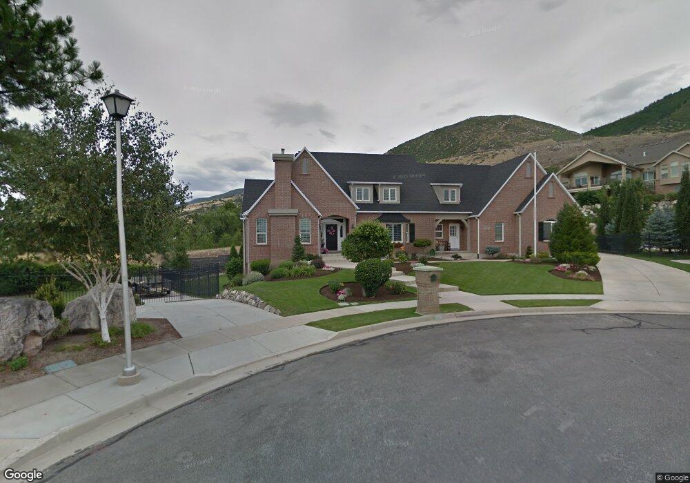
1556 Homestead Cir Centerville, UT 84014
Estimated Value: $1,032,000 - $1,221,000
4
Beds
3
Baths
3,010
Sq Ft
$374/Sq Ft
Est. Value
About This Home
This home is located at 1556 Homestead Cir, Centerville, UT 84014 and is currently estimated at $1,125,587, approximately $373 per square foot. 1556 Homestead Cir is a home located in Davis County with nearby schools including Stewart Elementary School, Centerville Jr High, and Viewmont High School.
Ownership History
Date
Name
Owned For
Owner Type
Purchase Details
Closed on
Aug 20, 2002
Sold by
Judkins J Andrew and Judkins Cari
Bought by
Tanner Varda
Current Estimated Value
Home Financials for this Owner
Home Financials are based on the most recent Mortgage that was taken out on this home.
Original Mortgage
$85,000
Outstanding Balance
$33,567
Interest Rate
5.62%
Estimated Equity
$1,092,020
Purchase Details
Closed on
Nov 5, 1999
Sold by
Robertson James L and Robertson Bonita
Bought by
Tanner Varda
Create a Home Valuation Report for This Property
The Home Valuation Report is an in-depth analysis detailing your home's value as well as a comparison with similar homes in the area
Home Values in the Area
Average Home Value in this Area
Purchase History
| Date | Buyer | Sale Price | Title Company |
|---|---|---|---|
| Tanner Varda | -- | United Title Services | |
| Tanner Varda | -- | Associated Title Company |
Source: Public Records
Mortgage History
| Date | Status | Borrower | Loan Amount |
|---|---|---|---|
| Open | Tanner Varda | $85,000 |
Source: Public Records
Tax History Compared to Growth
Tax History
| Year | Tax Paid | Tax Assessment Tax Assessment Total Assessment is a certain percentage of the fair market value that is determined by local assessors to be the total taxable value of land and additions on the property. | Land | Improvement |
|---|---|---|---|---|
| 2025 | $1,077 | $591,800 | $196,791 | $395,009 |
| 2024 | $639 | $559,900 | $183,449 | $376,451 |
| 2023 | $5,870 | $1,157,000 | $292,265 | $864,735 |
| 2022 | $5,747 | $534,050 | $149,326 | $384,724 |
| 2021 | $942 | $717,000 | $237,900 | $479,100 |
| 2020 | $4,480 | $644,000 | $227,275 | $416,725 |
| 2019 | $4,528 | $639,000 | $211,464 | $427,536 |
| 2018 | $4,240 | $592,000 | $195,354 | $396,646 |
| 2016 | $3,557 | $278,575 | $75,074 | $203,501 |
| 2015 | $3,517 | $260,700 | $75,074 | $185,626 |
| 2014 | $695 | $283,250 | $75,074 | $208,176 |
| 2013 | -- | $260,982 | $68,758 | $192,224 |
Source: Public Records
Map
Nearby Homes
- 145 Ford Canyon Dr
- 1441 N Main St
- 43 E 1825 N
- 1851 N Main St
- 1285 Nola Dr
- 0 N Rolling Hills Dr E Unit 2091690
- 2009 N 150 E
- 56 E 2050 N
- 1238 N 450 W
- 1927 N 450 W
- 455 W 2025 N
- 733 W 1825 N
- 5 W Summerhill Ln
- 271 Brookfield Ln
- 429 W 1050 N
- 1154 N 700 W
- Cantata Plan at Summerhill Lane
- Kilby Plan at Summerhill Lane
- Rhapsody Plan at Summerhill Lane
- Ballad Plan at Summerhill Lane
- 1540 Homestead Cir
- 1565 Ford Canyon Crossing
- 1551 Homestead Cir
- 1526 Homestead Cir
- 1529 Ford Canyon Dr
- 1511 Ford Canyon Dr
- 1510 Homestead Cir
- 1527 Homestead Cir
- 1553 Ford Canyon Dr
- 1493 Ford Canyon Dr
- 1490 Homestead Cir
- 1509 Homestead Cir
- 1532 Ford Canyon Dr
- 1514 Ford Canyon Dr
- 1518 N Main St
- 1589 Ford Canyon Crossing
- 133 Ford Canyon Dr
- 1496 Ford Canyon Dr
- 1514 N Main St
- 1616 N Main St