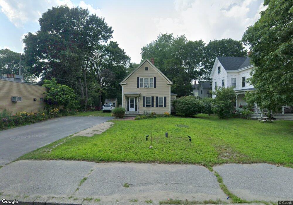
156 N Main St Middleboro, MA 02346
Estimated Value: $588,000 - $750,000
3
Beds
3
Baths
2,814
Sq Ft
$228/Sq Ft
Est. Value
About This Home
This home is located at 156 N Main St, Middleboro, MA 02346 and is currently estimated at $642,601, approximately $228 per square foot. 156 N Main St is a home located in Plymouth County with nearby schools including Mary K. Goode Elementary School and Mullein Hill Christian Academy.
Ownership History
Date
Name
Owned For
Owner Type
Purchase Details
Closed on
May 3, 1988
Sold by
Jonray Inc
Bought by
Sanborn Wayne E
Current Estimated Value
Create a Home Valuation Report for This Property
The Home Valuation Report is an in-depth analysis detailing your home's value as well as a comparison with similar homes in the area
Home Values in the Area
Average Home Value in this Area
Purchase History
| Date | Buyer | Sale Price | Title Company |
|---|---|---|---|
| Sanborn Wayne E | $161,000 | -- |
Source: Public Records
Mortgage History
| Date | Status | Borrower | Loan Amount |
|---|---|---|---|
| Open | Sanborn Wayne E | $250,000 | |
| Closed | Sanborn Wayne E | $100,000 | |
| Closed | Sanborn Wayne E | $50,000 | |
| Closed | Sanborn Wayne E | $117,200 |
Source: Public Records
Tax History
| Year | Tax Paid | Tax Assessment Tax Assessment Total Assessment is a certain percentage of the fair market value that is determined by local assessors to be the total taxable value of land and additions on the property. | Land | Improvement |
|---|---|---|---|---|
| 2025 | $6,187 | $461,400 | $168,600 | $292,800 |
| 2024 | $5,857 | $432,600 | $160,600 | $272,000 |
| 2023 | $5,834 | $409,700 | $160,600 | $249,100 |
| 2022 | $5,426 | $352,800 | $139,700 | $213,100 |
| 2021 | $5,197 | $319,400 | $122,600 | $196,800 |
| 2020 | $4,999 | $314,800 | $122,600 | $192,200 |
| 2019 | $4,661 | $301,100 | $122,600 | $178,500 |
| 2018 | $4,388 | $281,300 | $116,800 | $164,500 |
| 2017 | $3,988 | $252,900 | $112,300 | $140,600 |
| 2016 | $4,042 | $253,900 | $102,800 | $151,100 |
| 2015 | $3,887 | $246,300 | $102,700 | $143,600 |
Source: Public Records
Map
Nearby Homes
- 17 School St
- 28 School St
- 0 Wareham Miller St Unit 73410845
- 87 Pearl St
- 6 Rock St
- 18 Rock St
- 75 Oak St
- 1 Bloomfield Ave
- 12 Southwick St
- 15 E Grove St
- 80 Forest St
- 17 Cobblestone Ln
- 132 Everett St
- 958 Centre St
- 121 North St
- 26 Susan Ln
- LOT A Wood St
- 227 E Main St
- 17 Landing Way Unit 17
- 145 Wesley Cir
- 170 N Main St
- 134 N Main St
- 4 Reland St Unit 3
- 4 Reland St Unit 1
- 132 N Main St
- 132 N Main St Unit 1
- 132 N Main St Unit 2
- 6 Reland St
- 6 Reland St
- 182 N Main St
- 8 Reland St
- 8 Reland St
- ooo Tanning
- 0 Off Route 79 Rhode Island Rd Unit 71480747
- 00000 Xxxxx
- xxx Xxx
- 0 Don Bouchard Way Unit 71757667
- 0 Off Cinnamon Ridge Cir Unit 71572046
- 0 Don Bouchard Way Unit 71757666
- lotB Cedar St
Your Personal Tour Guide
Ask me questions while you tour the home.